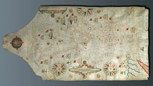
Manuscript portolan chart of the Mediterranean Sea 1640


Item Number: 25103 Authenticity Guarantee
Category: Antique maps > Mediterranean Sea
A highly decorative manuscript portolan chart of the Mediterranean Sea by Placidus Caloiro et Oliva.
Ink and watercolour on vellum
Size: 85 x 44cm (33.2 x 17.2 inches)
Verso: Blank
Condition: Excellent.
Condition Rating: A
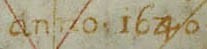
The upper part of the sheet is cut into triangle shape and is decorated with a circular image of the Virgin and Child (85 x 85 mm) with below the following text in gold: Placidus Caloiro et Olivia fecit in nobili urbe Messane Anno 1640.
The coastal places are plotted in red and brown ink; the major cities are represented by groups of buildings bearing a coloured flag. The isles are painted in red, blue and green. There are 12 small compass roses and 2,5 big ones + two cartouches. Some rivers are shown in blue and the African coast is decorated with two palms, the Red Sea is coloured in red. The centre of the map shows Sicily, the place where the map was made.
The map is well preserved and in general, the colours are vivid. There is an inscription on the back: Archives de Merode- Westerloo - Bruxelles (handwriting 19th or begin 20th century).
Framed.