
Mediterranean Sea by Pierre Mortier 1694


Covens & Mortier. A Map Publishing House in Amsterdam. 1721-1866.
During almost two centuries, the largest and most important Dutch publishing house in commercial cartography was the Amsterdam firm of Covens & Mortier. Concerning quantity, it was possibly even the biggest contemporary map-trading house worldwide. They distributed innumerable maps, atlases, globes, and books.
Pieter (Pierre) Mortier (Leiden, 1661 – Amsterdam, 1711)
Nothing is known about the youth of Pieter Mortier. He studied in Paris from 1681 to approximately 1685. There he must have come into contact with French 'libraires' and learned the bookselling trade. Beginning 1685 he returned to Amsterdam where he opened a small bookshop. In the same year, he became a member of the Book, Art Sellers' and Printers' guild.
Pieter sold books in Dutch and foreign languages, but he also published books on his own, usually in the French language. His business flourished such that in 1688 he was already forced to rent another house on the Vijgendam.
Pieter Mortier's first privilege for maps was granted by the States of Holland and West Friesland on September 15 1690. It refers to the maps of Sanson that he 'is printing and correcting with great pains and care'.
Pieter began the large scale publication of maps and atlases. By the beginning of the 18th century, Pieter had become so wealthy that he could purchase three houses in Amsterdam: on the Beurssluis, on the Vijgendam, and the Heremietensteeg. He rebuilt the house on the Vijgendam into a large prestigious house that would serve for over a century as a shop, business, and residential structure for Covens & Mortier's publishing house.
He died on February 13, 1711, after a brief illness. The company continued to exist under Pieter's widow's management, Amelia' s-Gravesande.
After she died in 1719, her son Cornelis, took over the management for a few years.
On November 20, 1721, a company was founded by Cornelis Mortier and Johannes Covens I. The latter was married the same year with Cornelis's sister. From that year on, the name of :
Covens & Mortier.
Their firm would see a massive expansion in the next 140 years. In 1732 the heirs sold the property to their brother Cornelis and his partner Covens. Their main competitors were Reinier & Josua Ottens and Gerard Valck & Petrus Schenck. After the death of Johannes Covens I (1774), his son Johannes Covens II (1722-1794) entered the business. From 1778, Johannes added a new company name :
J. Covens & Son.
Johannes Covens II was succeeded by his son Cornelis Covens (1764-1825), who, in turn, brought Peter Mortier IV, the great-grandson of Petrus Mortier I, into the business. The name was from 1794 to 1866:
Mortier, Covens & Son.
The last Covens in the series was Cornelis Johannes Covens (1806-1880).
Covens & Mortier had a large stock of atlases and maps, including those of: Delisle, Jaillot, Johannes Janssonius, Sanson, Claes Jansz. Visscher, Nicolaas Visscher, and Frederik de Wit. For decades, an impressive number of atlases came from the press.
Carte Nouvelle de la Mer Mediterranee ou sont Exactement Remarques Tous les Ports, Golfes, Rochers, Bancs de Sable &c.
Item Number: 27662 Authenticity Guarantee
Category: Antique maps > Mediterranean Sea
Antique sea chart of the Mediterranean Sea, by R. de Hooghe, published by Pierre Mortier.
Embellished with 38 insets of major ports and cities of the Mediterranean.
Second state (of four) with corrected title (an extra 'R' is added in the title-word 'Mediteranee'), and the imprint of Pierre Mortier.
Date of the first edition: 1694
Date of this map: 1694
Date on map: 1694
Copper engraving, printed on paper.
Size (not including margins): 59.5 x 141cm (23.2 x 55 inches)
Verso: Blank
Condition: Old body colour, excellent.
Condition Rating: A+
References: van Egmond, p.331, 9.2; Putman, Early Sea Charts, p.22, pl.7; Campbell, Early Maps, pp. 96-7.
From: Atlas Maritime. Amsterdam, Pierre Mortier, 1694.
Joint: Frontispice of the atlas, engraved by Romeyn de Hooghe.
Size, not including margins: 53 x 37 cm.
Condition: Original coloured, excellent.
Reference: Shirley (Titlepages), #71
The frontispiece is rich in allegorical symbols and shows Romeyn de Hooghe at the height of his powers. The royal arms of Great Britain hang from an imposing pair of pillars, strongly suggestive of strength and solidity. To the left, the King's enemies - the French - flee in disorder up an arched hill. The exciting tussle of forces in the lower third of the piece is partly elucidated by the ten lines of Latin verse below the title.
Covens & Mortier. A Map Publishing House in Amsterdam. 1721-1866.
During almost two centuries, the largest and most important Dutch publishing house in commercial cartography was the Amsterdam firm of Covens & Mortier. Concerning quantity, it was possibly even the biggest contemporary map-trading house worldwide. They distributed innumerable maps, atlases, globes, and books.
Pieter (Pierre) Mortier (Leiden, 1661 – Amsterdam, 1711)
Nothing is known about the youth of Pieter Mortier. He studied in Paris from 1681 to approximately 1685. There he must have come into contact with French 'libraires' and learned the bookselling trade. Beginning 1685 he returned to Amsterdam where he opened a small bookshop. In the same year, he became a member of the Book, Art Sellers' and Printers' guild.
Pieter sold books in Dutch and foreign languages, but he also published books on his own, usually in the French language. His business flourished such that in 1688 he was already forced to rent another house on the Vijgendam.
Pieter Mortier's first privilege for maps was granted by the States of Holland and West Friesland on September 15 1690. It refers to the maps of Sanson that he 'is printing and correcting with great pains and care'.
Pieter began the large scale publication of maps and atlases. By the beginning of the 18th century, Pieter had become so wealthy that he could purchase three houses in Amsterdam: on the Beurssluis, on the Vijgendam, and the Heremietensteeg. He rebuilt the house on the Vijgendam into a large prestigious house that would serve for over a century as a shop, business, and residential structure for Covens & Mortier's publishing house.
He died on February 13, 1711, after a brief illness. The company continued to exist under Pieter's widow's management, Amelia' s-Gravesande.
After she died in 1719, her son Cornelis, took over the management for a few years.
On November 20, 1721, a company was founded by Cornelis Mortier and Johannes Covens I. The latter was married the same year with Cornelis's sister. From that year on, the name of :
Covens & Mortier.
Their firm would see a massive expansion in the next 140 years. In 1732 the heirs sold the property to their brother Cornelis and his partner Covens. Their main competitors were Reinier & Josua Ottens and Gerard Valck & Petrus Schenck. After the death of Johannes Covens I (1774), his son Johannes Covens II (1722-1794) entered the business. From 1778, Johannes added a new company name :
J. Covens & Son.
Johannes Covens II was succeeded by his son Cornelis Covens (1764-1825), who, in turn, brought Peter Mortier IV, the great-grandson of Petrus Mortier I, into the business. The name was from 1794 to 1866:
Mortier, Covens & Son.
The last Covens in the series was Cornelis Johannes Covens (1806-1880).
Covens & Mortier had a large stock of atlases and maps, including those of: Delisle, Jaillot, Johannes Janssonius, Sanson, Claes Jansz. Visscher, Nicolaas Visscher, and Frederik de Wit. For decades, an impressive number of atlases came from the press.
Related items
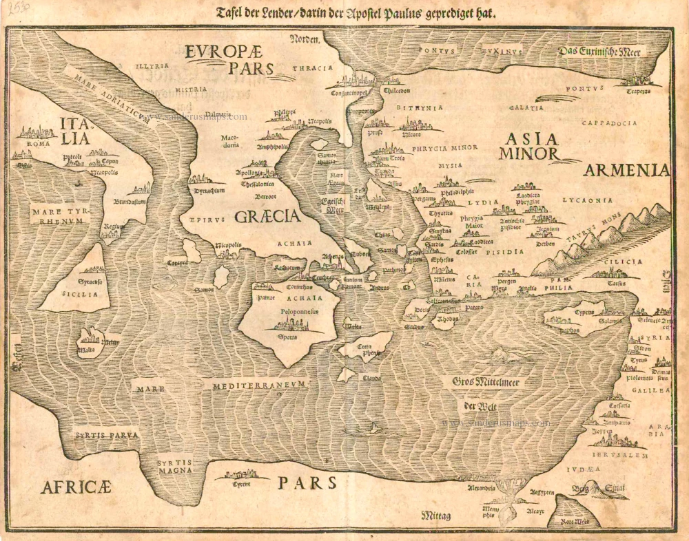
Tafel der Lender darin der Apostel Paulus geprediget hat. 1581
Eastern part of the Mediterranean Sea, by Heinrich Bünting.
[Item number: 2530]
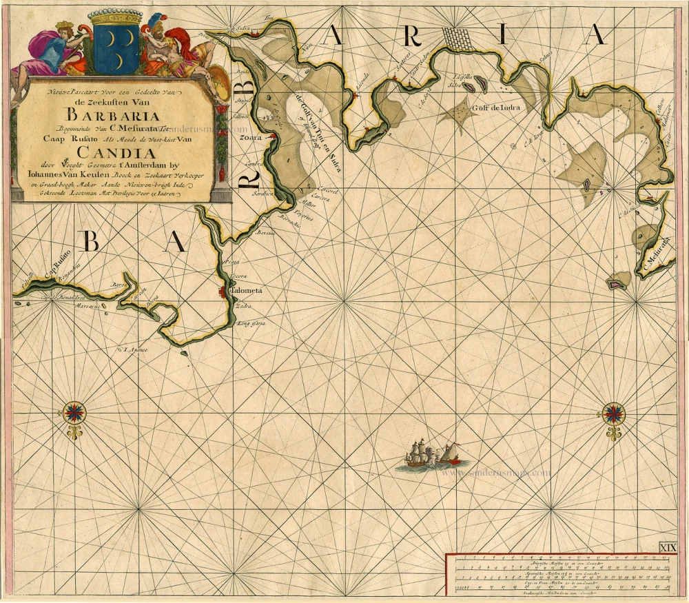
Nieuwe Pascaart voor een Gedeelte van de Zeekusten van Barbaria Beginnende van C. Mesurata tot Caap Rusato Als mede de West-kust van Candia. 1697-1709
Sea chart of the coasts of Morocco, by Johannes Van Keulen.
[Item number: 6506]
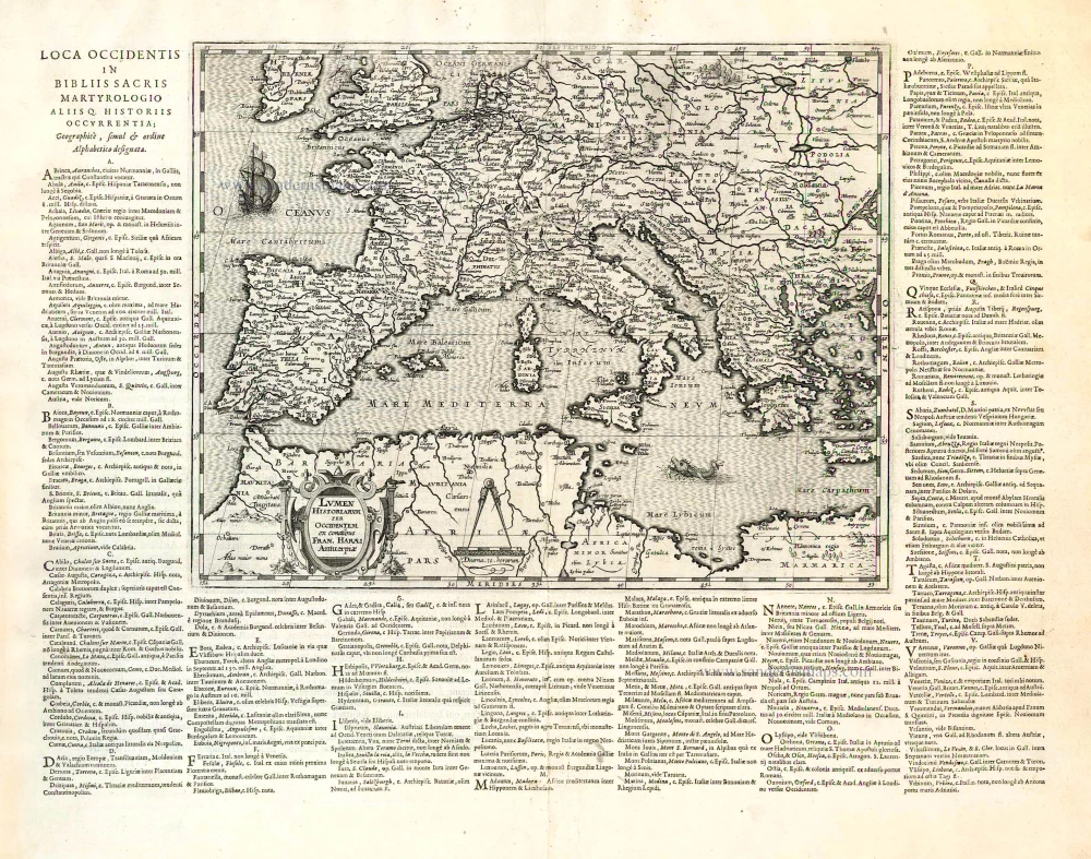
Lumen Historiarum per Occidentem. . . . 1624
Europe - Western Mediterranean Sea, by A. Ortelius.
[Item number: 26573]
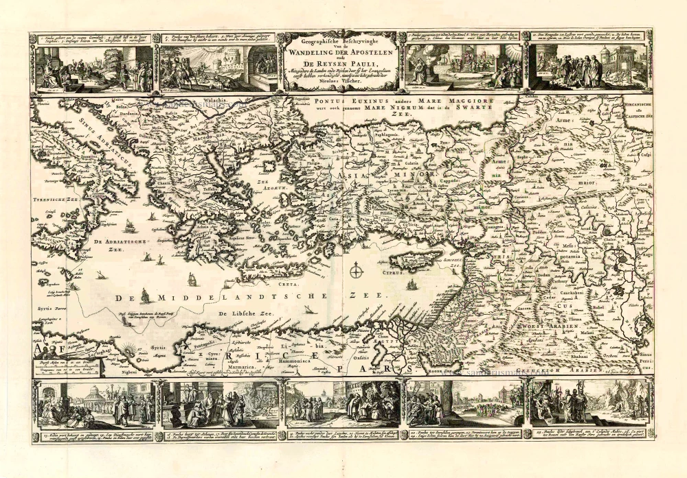
Geografische Beschryvinghe van de Wandeling der Apostelen ende De Reysen Pauli, Mitsgaders de Landen ende Rijcken daer sij het Evangelium eerst hebben verkondight. ... c. 1664
Eastern Mediterranean Sea, by Nicolaes Visscher I.
[Item number: 27590]
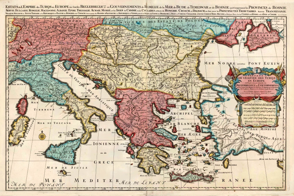
Estats de l'Empire des Turqs en Europe. c. 1705
European Ottoman Empire by Nicolas Sanson, published by Pieter Mortier.
[Item number: 27770]