
Indian Ocean, by J.N. Bellin. 1756-1770
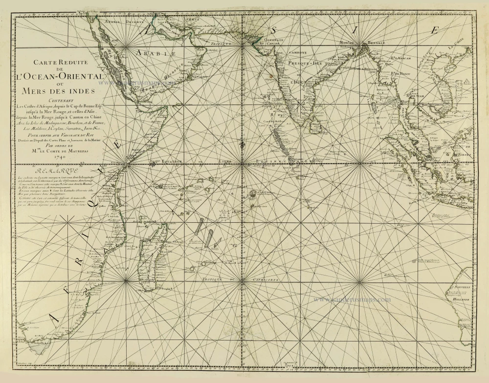
First state of Bellin's important chart of the Indian Ocean, the most accurate chart of the Indian Ocean of the 18th century. It covers the area from Eastern Africa with Madagascar, Arabia, India, South East Asia and the Spice Islands to Western Australia.
There was considerable French interest in the Indian Ocean: from 1735 there were French efforts to completely colonise Mauritius, La Réunion and and the Seychelles. Two years after the map was published the Compagnie Perpétuelle des Indes would make a bid for greater control in India. Madagascar was of interest as a centre of piracy.
Carte Réduite de l'Océan Oriental ou Mers des Indes.
Item Number: 28148 Authenticity Guarantee
Category: Antique maps > Oceans
Old, antique sea chart of Indian Ocean, by Bellin J.N..
Title: Carte Réduite de l'Océan Oriental ou Mers des Indes.
Contenant Les Costes d'Afrique, depuis le Cap de Bonne Esp.ce jusqu'à la Mer Rouge, et celles d'Asie.
depuis la Mer Rouge, jusqu'à Canton en Chine.
Avec les Isles de Madagascar, Bourbon, et de France, Les Maldives. I. Ceylan, Sumatra, Java &c.
Pour servir auc Vaisseaux du Roi
Dressée au Dépost des Cartes Plans et Journeaux de la Marine
Par Ordre de Mgr. Le Comte de Maurepas.
1740
Dheulland Sculp.
First state.
Engraver: Guillaume Dheulland.
Date of the first edition: 1740.
Date of this map: 1740.
Date on map: 1740.
Copper engraving, printed on paper.
Size (not including margins): 610 x 790mm (24.02 x 31.1 inches).
Verso: Blank.
Condition: Uncoloured, excellent.
Condition Rating: A+.
References: Norwich, #280 (2nd ed.); Clancy, p. 35 (2nd ed.); Tooley (Australia), #155 (2nd ed)
From: L'Hydrographie Françoise ou Recueil des Cartes Dressées au Deposit des Plans de la Marine pour le Service des Vaisseaux du Roy. Paris, 1756-70. (Shirley (Brit.Lib.), M.Bell-2a)
First state of Bellin's important chart of the Indian Ocean, the most accurate chart of the Indian Ocean of the 18th century. It covers the area from Eastern Africa with Madagascar, Arabia, India, South East Asia and the Spice Islands to Western Australia.
There was considerable French interest in the Indian Ocean: from 1735 there were French efforts to completely colonise Mauritius, La Réunion and and the Seychelles. Two years after the map was published the Compagnie Perpétuelle des Indes would make a bid for greater control in India. Madagascar was of interest as a centre of piracy.
