
Rare
Title page of Hendrick Doncker's Zee-Atlas - Water World. 1661

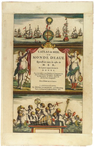
The title page to Doncker's Zee-Atlas consists of three panels. In the centre, two buxom, scantily dressed maidens support the drapery, which reveals the title. One holds a cross-staff; the other, a portable mariner's astrolabe. At the top is a globe above which Atlas, in a half-kneeling position, holds up the heavens. In the background, a panoramic flotilla of ships can be seen in full sail.
The bottom panel has a group of putti frolicking around an anchored buoy and playing with various navigational instruments. Also in the scene to the right is a suckling mermaid and, to the left, a bearded merman who is having his drinking horn emptied over his head by a particularly sad or drunken putto. Doncker's design must have enjoyed himself constructing such a light-hearted scene, unaware that the English map-maker and publisher Philip Lea was to copy Doncker's design in reverse in about 1689 and reprint it over the next forty years.
Hendrick Doncker (1625-1699)
Hendrick Doncker became a member of the bookseller's guild in 1647 and ran his shop successfully for fifty years. He was able to develop one of the most popular sets of maritime works published in Amsterdam during the Golden Age.
In 1651 he bought a house in the Nieuwe Brugsteeg in Amsterdam. It was called 'in 't Stuurmans gereetschap' (in the mariners' instruments) and stood opposite the house where Johannes van Keulen later settled.
Apart from the sea atlases, charts and pilot books, Hendrik Doncker published various editions of textbooks on the art of navigation.
After the death of Hendrick Doncker, the son, Hendrick II (c. 1664-c.1739), continued publishing the sea atlases Zeeatlas and Zeespiegel until 1708.
Doncker's charts were the most up-to-date in the second half of the 17th century. Although there is some similarity to those charts published by Van Loon, Goos, Lootsman, and Doncker, the latter's charts are original.
In 1655, Hendrick Doncker had begun with the publication of a pilot guide, the Lichtende Columne ofte Zeespiegel. In 1659 he published his first sea atlas, the Zee-Atlas of Waeter-waereld, with 19 maps. Between 1659 and 1669, he increased the number of charts from 19 to 30 and in 1669 he came with an edition containing 50, which was soon to be followed by an edition with large maps: the Nieuwe Groote Vermeerderde Zeeatlas, also with 50 charts. This beautiful atlas was reprinted and continually improved for more than 25 years. After the death of Hendrick Doncker in 1699, his son continued the publication and even enlarged and enhanced the sea-atlas.
L'Atlas de Mer, ou Monde d'Eaue. Remonstrant toutes les costes du Mer, de la partië cognuë de toute le Monde.
Item Number: 32622 Authenticity Guarantee
Category: Antique maps > Title Pages
Title page by Hendrick Doncker.
Title: L'Atlas de Mer, ou Monde d'Eaue. Remonstrant toutes les costes du Mer, de la partië cognuë de toute le Monde.
A Amstelredamme, Par Henri Doncker, en la Nieu-brugstegue, a l'enseigne des Utensiles des Pilotes. 1661.
Date: 1661.
Date on map: 1661.
Copper engraving, printed on paper.
Image size: 370 x 215mm (14½ x 8½ inches).
Sheet size: 450 x 280mm (17¾ x 11 inches).
Verso: Blank.
Condition: Original coloured, new upper- and lower margins.
Condition Rating: A.
From: L'Atlas de Mer, ou Monde d'Eaue. Remonstrant toutes les costes du Mer, De la partië cognuë de toute le Monde. Amsterdam, H. Doncker, 1661.
The title page to Doncker's Zee-Atlas consists of three panels. In the centre, two buxom, scantily dressed maidens support the drapery, which reveals the title. One holds a cross-staff; the other, a portable mariner's astrolabe. At the top is a globe above which Atlas, in a half-kneeling position, holds up the heavens. In the background, a panoramic flotilla of ships can be seen in full sail.
The bottom panel has a group of putti frolicking around an anchored buoy and playing with various navigational instruments. Also in the scene to the right is a suckling mermaid and, to the left, a bearded merman who is having his drinking horn emptied over his head by a particularly sad or drunken putto. Doncker's design must have enjoyed himself constructing such a light-hearted scene, unaware that the English map-maker and publisher Philip Lea was to copy Doncker's design in reverse in about 1689 and reprint it over the next forty years.
Hendrick Doncker (1625-1699)
Hendrick Doncker became a member of the bookseller's guild in 1647 and ran his shop successfully for fifty years. He was able to develop one of the most popular sets of maritime works published in Amsterdam during the Golden Age.
In 1651 he bought a house in the Nieuwe Brugsteeg in Amsterdam. It was called 'in 't Stuurmans gereetschap' (in the mariners' instruments) and stood opposite the house where Johannes van Keulen later settled.
Apart from the sea atlases, charts and pilot books, Hendrik Doncker published various editions of textbooks on the art of navigation.
After the death of Hendrick Doncker, the son, Hendrick II (c. 1664-c.1739), continued publishing the sea atlases Zeeatlas and Zeespiegel until 1708.
Doncker's charts were the most up-to-date in the second half of the 17th century. Although there is some similarity to those charts published by Van Loon, Goos, Lootsman, and Doncker, the latter's charts are original.
In 1655, Hendrick Doncker had begun with the publication of a pilot guide, the Lichtende Columne ofte Zeespiegel. In 1659 he published his first sea atlas, the Zee-Atlas of Waeter-waereld, with 19 maps. Between 1659 and 1669, he increased the number of charts from 19 to 30 and in 1669 he came with an edition containing 50, which was soon to be followed by an edition with large maps: the Nieuwe Groote Vermeerderde Zeeatlas, also with 50 charts. This beautiful atlas was reprinted and continually improved for more than 25 years. After the death of Hendrick Doncker in 1699, his son continued the publication and even enlarged and enhanced the sea-atlas.