
Antique map of the North Pole by G. Mercator. 1633

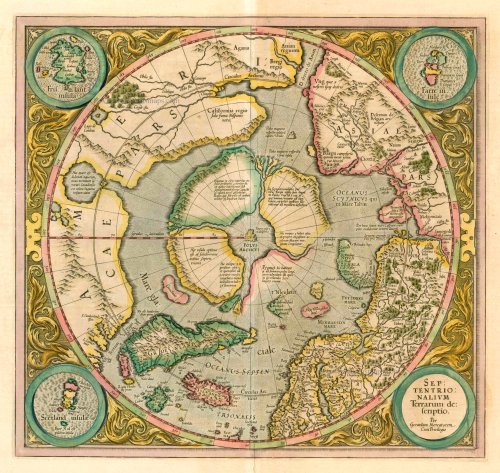
Septentrionalium Terrarum descriptio
Item Number: 6493 Authenticity Guarantee
Category: Antique maps > World
Antique map of the North Pole by G. Mercator.
Date of the first edition: 1595
Date of this map: 1633
Copper engraving
Size: 37 x 40cm (14.4 x 15.5 inches)
Verso text: French
Condition: Contemporary old coloured, excellent.
Condition Rating: A
References: Van der Krogt 1, 0020:1A; Burden 88, State 2; Wagner, 177.
From: L'Appendice de l'Atlas De Gerard Mercator et Iudocus Hondius ... Amsterdam, H. Hondius, 1633. (Van der Krogt 1, 312)
In the second half of the sixteenth century polar geography became the subject of intense speculation. It was widely assumed that there was no land bridge between north-east Asia and north-west America and that the polar regions were separated from both continents by the sea. This was also the view taken by the foremost contemporary geographers, including Gerard Mercator, Abraham Ortelius and John Dee. The polar rock with its four surrounding islands separated by swirling torrents were universally accepted as real and can be seen e.g. in the small map inset into Mercator's wall-map of the world (1569) and Dee's polar map (c.1582).
This is the first map devoted to the Arctic. In the corners are four roundels, one of these contains the title, the other three contain maps of the Faeroe Isles, the Shetland Isles and the mythical island of Frisland.
Second state with one island (lower right) with an incomplete coast.