Antique map of World by Oronce Fine 1540
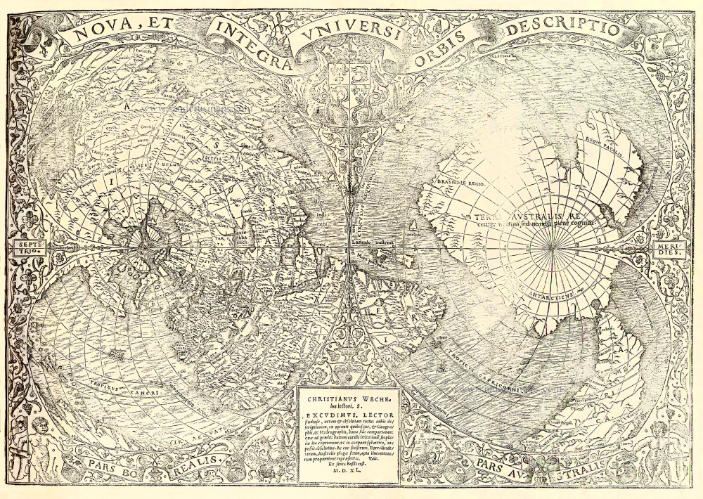
Nova, Et Integra Universi Orbis Descriptio.
Item Number: 21420 Authenticity Guarantee
Category: Antique maps > World and Polar
Woodcut map included in a beautiful copy of Pomponius Mela's De Orbis Situ. Paris, 1640.
(For the description of the book see our Book Department - Under construction.)
Date on map: 1540
Size: 29 x 42cm (11 x 16 inches)
Verso: Blank
Condition: Printed on 3 joined sheets, excellent.
References: Shirley (World), 66 State 4; Clancy, p.122 Map 8.1.
In: MELA Pomponius. De Orbis Situ libri tres. Paris, Christian Wechel, 1540.
"The eminent French cartographer Oronce Fine prepared this double-cordiform map: a rendering considerably in advance of any others printed earlier. ...
Fine's map is a detailed woodcut, geographically much superior to the large oval map by Sebastian Münster-Hans Holbein in the Basle editions. Much of the right-hand (or southern) cordum is taken up with the new Terra Australis, noted as being 'recently discovered but not yet explored.' Beyond the tip of South America is marked the Mare magellanicum, one of he first uses of the navigator's name in such a context. Central America contains numerous place names reflecting the conquests and explorations of Cortez in the early 1520s, but further north Fine has unambiguously made the North America continent part of the eastern extremity of Asia. Four islands make up the north polar regions. The separate island of Greenland is named, and a large promontory marked Gaccalar (supposedly Labrador) extend from the North American land mass into the Atlantic.
There is a detailed floral surround to the map, two mermaids, two muscular cherubs, the French royal coat of arms and, at the head of the map, the title in a flowing banner. Oronce Fine's map is one that deserved enlargement on to two sheets. Unfortunately, in many cases the margins of surviving copies are badly frayed as after folding once for insertion into the book they were still too wide for the binding." (Shirley)
Finé's map is also one of the earliest printed maps to show the southern continent as a distinct landmass to counterbalance, cartographically speaking, the northern hemisphere.