
Double hemisphere. by Zürner A.F. c. 1700
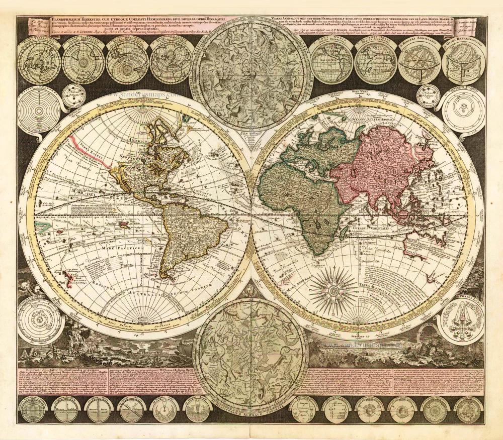
The cartographer Adam Zürner is noted by Bagrow as having an output of over 900 maps, but despite this, he is relatively unknown. This exciting and detailed world map is among several maps produced for Peter Schenk. The two main hemispheres are cartographically up-to-date and show explorers' routes, including Magellan, Dampier, Tasman, Gaetani and Chaumont. Nova Britannia, an island adjacent to New Guinea, is shown with an inscription saying that Dampier discovered it in 1700. Encircling the hemispheres are markings of the winds and climates, and set around the border are no less than twenty-six smaller astronomical diagrams and hemispheres of the world according to different projections. In addition, there are two larger celestial hemispheres and, at the bottom, a panorama illustrating storms, earthquakes, tides, vortices, etc. Below, there is a textual commentary on the natural phenomena depicted. Similar engravings of the earth's physical forces appear in the later general map by J.B. Homann. (Shirley)
Adam Friedrich Zürner (1679-1742)
A.F. Zürner made his first maps during his studies in Leipzig. In 1713, Elector August dem Starken gave him the order to bring all offices of the Electorate of Saxony in the same way as the two maps of the offices of Großenhain and Dresden. Zürner was supposed to complete the electorate survey, which was begun in 1586 by Matthias Oeder under Elector Christian I.
In 1716 he was awarded the title of "Electoral Saxon and Royal Polish Geographer". In the same year, he was appointed a member of the Prussian Academy of Sciences. Finally, in the late autumn of 1718, he presented his "New Chursächsische Post-Charte".
The geographer Johann Gottfried Gregorii alias Melissantes and the copper engraver Johann Christoph Weigel from Nuremberg used the good map material and Zürner's signature system as early as 1723 to create the continuous Atlas Portatilis Germanicus.
In addition to his surveying work, Zürner wrote several travel guides in the last years of his life. He worked, among others, with the Homann Heirs firm and the Schenk family. He died on December 18, 1742, in Dresden.
Today he is considered a well-known German cartographer. His best-known works were the Neue Chursächsische Post-Charte (16 sheets) and the Atlas Augusteus der Chursächsische Lande (Atlas Augusteus Saxonicus: 40 general and 40 special maps).
Planisphaerium Terrestre Cum Utroque Coelesti Hemisphaerio, sive Diversa Orbis Terraquei ... Opera et studio A.F. Zûrneri . . . Ex Officina Petri Schenkii in Platea vulgo. [Title repeated in Dutch].
Item Number: 25655 Authenticity Guarantee
Category: Antique maps > World
Old, antique map of Double hemisphere., by Zürner A.F..
Title: Planisphaerium Terrestre Cum Utroque Coelesti Hemisphaerio, sive Diversa Orbis Terraquei ... Opera et studio A.F. Zûrneri . . . Ex Officina Petri Schenkii in Platea vulgo. [Title repeated in Dutch].
Cartographer: Adam F. Zurner.
Date of the first edition: c. 1700.
Date of this map: c. 1700.
Copper engraving, printed on paper.
Size (not including margins): 505 x 575mm (19.88 x 22.64 inches).
Verso: Blank.
Condition: Original coloured, excellent.
Condition Rating: A+.
References: Shirley (World), 639;
From: Schenk, Atlas Contractus sive Mapparum Geographicarum Sansoniarum auctarum et Correctarum. Amsterdam, c. 1700. (Koeman, Sche 2)
The cartographer Adam Zürner is noted by Bagrow as having an output of over 900 maps, but despite this, he is relatively unknown. This exciting and detailed world map is among several maps produced for Peter Schenk. The two main hemispheres are cartographically up-to-date and show explorers' routes, including Magellan, Dampier, Tasman, Gaetani and Chaumont. Nova Britannia, an island adjacent to New Guinea, is shown with an inscription saying that Dampier discovered it in 1700. Encircling the hemispheres are markings of the winds and climates, and set around the border are no less than twenty-six smaller astronomical diagrams and hemispheres of the world according to different projections. In addition, there are two larger celestial hemispheres and, at the bottom, a panorama illustrating storms, earthquakes, tides, vortices, etc. Below, there is a textual commentary on the natural phenomena depicted. Similar engravings of the earth's physical forces appear in the later general map by J.B. Homann. (Shirley)
Adam Friedrich Zürner (1679-1742)
A.F. Zürner made his first maps during his studies in Leipzig. In 1713, Elector August dem Starken gave him the order to bring all offices of the Electorate of Saxony in the same way as the two maps of the offices of Großenhain and Dresden. Zürner was supposed to complete the electorate survey, which was begun in 1586 by Matthias Oeder under Elector Christian I.
In 1716 he was awarded the title of "Electoral Saxon and Royal Polish Geographer". In the same year, he was appointed a member of the Prussian Academy of Sciences. Finally, in the late autumn of 1718, he presented his "New Chursächsische Post-Charte".
The geographer Johann Gottfried Gregorii alias Melissantes and the copper engraver Johann Christoph Weigel from Nuremberg used the good map material and Zürner's signature system as early as 1723 to create the continuous Atlas Portatilis Germanicus.
In addition to his surveying work, Zürner wrote several travel guides in the last years of his life. He worked, among others, with the Homann Heirs firm and the Schenk family. He died on December 18, 1742, in Dresden.
Today he is considered a well-known German cartographer. His best-known works were the Neue Chursächsische Post-Charte (16 sheets) and the Atlas Augusteus der Chursächsische Lande (Atlas Augusteus Saxonicus: 40 general and 40 special maps).
Related items

Orbis Vetus in utraque Continente juxta Mentem Sansonianam Distinctus, nec non Observationibus Astronomicis Redactus ... c. 1757
The world by Robert de Vaugondy.
[Item number: 5092]
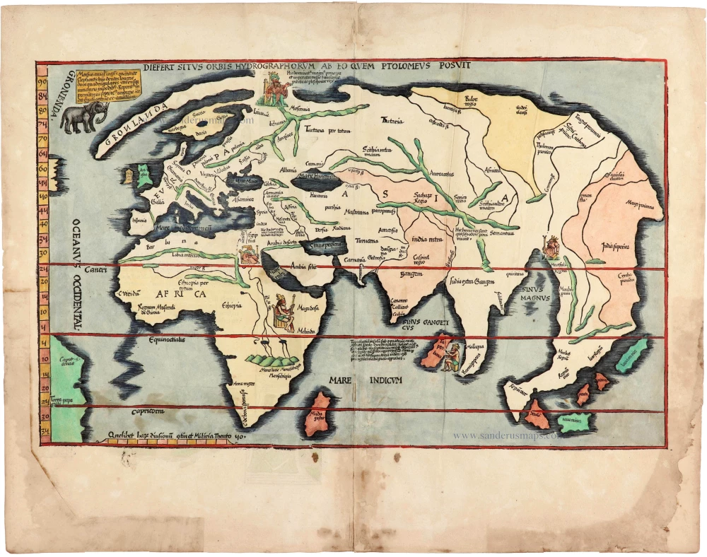
Rare 1525 edition of the second modern world map by Fries, in nice old colour.
Diefert Situs Orbis Hydrographorum Ab Eo Quem Ptolomeus Posuit. 1525
Modern world map, by Lorenz Fries, after Martin Waldseemüller.
[Item number: 30661]