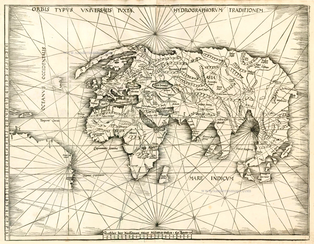
Old antique map of the World by Martin Waldseemüller 1513
The Strassbourg Ptolemy is the most important edition of the Geographia. Preparatory work was begun in about 1505 by Martin Waldseemüller, scholar-geographer of the small town of St. Dié in Lorraine, together with his associate Mathias Ringmann. Waldseemüller is believed to have incised many of the maps himself; all are firm distinctive woodcuts. By 1507 much progress had been made but the project was delayed and was not completed until 1513 under the editorship of Jacob Eszler and Georg Ubelin. The printer was Johann Schott, and the work, the first modern atlas, bears a dedication to the Emperor Maximilian.
"The representation of the Americas is most rough and incomplete, as if Waldseemüller felt uncertain about the shape of the New World, in spite of relatively accurate maps available six or seven years earlier. It is a reasonable conjecture that the world map now appearing was completed in the years when work on the atlas commenced - say in 1505 or 1506 - and was then laid aside and not revised when the work finally went to press in 1513. South America is shown in part outline; north of it are the islands of isabella (Cuba) and spagnolla (Haiti/Dominican Republic). Then, unnamed in mid-Atlantic, is a small piece of land of which the east coast only has been sketched in. ...
In the introductory text to the atlas there is an ambiguous passage referring to the Charta autem Marina . . ., (i.e. a Mariners' Chart) derived from observations made by the 'Admiral' or Christopher Columbus." (Shirley)
Orbis Typus Universalis iuxta Hydrographorum Traditionem.
Item Number: 12548 Authenticity Guarantee
Category: Antique maps > World and Polar
Old, antique world map by Martin Waldseemüller.
Date of the first edition: 1513
Date of this map: 1513
Woodcut
Size: 44.5 x 57cm (17.4 x 22.2 inches)
Verso: Blank
Condition: Printed on thick paper, several filled wormholes, else excellent.
Condition Rating: B
References: Shirley (World), 35; Karrow, 80/32; Suarez (Veil), 11.
From: Claudii Ptolemei viri Alexandrini Mathematice discipline Philosophi dictissimi Geographiae opus novissima . . . Strassburg, J. Schott, 1513.
The Strassbourg Ptolemy is the most important edition of the Geographia. Preparatory work was begun in about 1505 by Martin Waldseemüller, scholar-geographer of the small town of St. Dié in Lorraine, together with his associate Mathias Ringmann. Waldseemüller is believed to have incised many of the maps himself; all are firm distinctive woodcuts. By 1507 much progress had been made but the project was delayed and was not completed until 1513 under the editorship of Jacob Eszler and Georg Ubelin. The printer was Johann Schott, and the work, the first modern atlas, bears a dedication to the Emperor Maximilian.
"The representation of the Americas is most rough and incomplete, as if Waldseemüller felt uncertain about the shape of the New World, in spite of relatively accurate maps available six or seven years earlier. It is a reasonable conjecture that the world map now appearing was completed in the years when work on the atlas commenced - say in 1505 or 1506 - and was then laid aside and not revised when the work finally went to press in 1513. South America is shown in part outline; north of it are the islands of isabella (Cuba) and spagnolla (Haiti/Dominican Republic). Then, unnamed in mid-Atlantic, is a small piece of land of which the east coast only has been sketched in. ...
In the introductory text to the atlas there is an ambiguous passage referring to the Charta autem Marina . . ., (i.e. a Mariner's Chart) derived from observations made by the 'Admiral' or Christopher Columbus." (Shirley)
The Strassbourg Ptolemy is the most important edition of the Geographia. Preparatory work was begun in about 1505 by Martin Waldseemüller, scholar-geographer of the small town of St. Dié in Lorraine, together with his associate Mathias Ringmann. Waldseemüller is believed to have incised many of the maps himself; all are firm distinctive woodcuts. By 1507 much progress had been made but the project was delayed and was not completed until 1513 under the editorship of Jacob Eszler and Georg Ubelin. The printer was Johann Schott, and the work, the first modern atlas, bears a dedication to the Emperor Maximilian.
"The representation of the Americas is most rough and incomplete, as if Waldseemüller felt uncertain about the shape of the New World, in spite of relatively accurate maps available six or seven years earlier. It is a reasonable conjecture that the world map now appearing was completed in the years when work on the atlas commenced - say in 1505 or 1506 - and was then laid aside and not revised when the work finally went to press in 1513. South America is shown in part outline; north of it are the islands of isabella (Cuba) and spagnolla (Haiti/Dominican Republic). Then, unnamed in mid-Atlantic, is a small piece of land of which the east coast only has been sketched in. ...
In the introductory text to the atlas there is an ambiguous passage referring to the Charta autem Marina . . ., (i.e. a Mariners' Chart) derived from observations made by the 'Admiral' or Christopher Columbus." (Shirley)


