
Old antique map of the World in north polar projection, by L. Renard. by L. Renard 1715
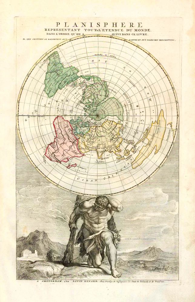


This is the engraved frontispiece to Renard's sea atlas. It shows the globe supported on the shoulders of Hercules, who can be recognised by his lion skin and club.
In one version of the story of his labours, Hercules held up the world while Atlas, who usually had that burden, stole the 'Apples of Hesperides' from his daughters. However, Hercules then had to trick Atlas into resuming his responsibility.
The projection is unusual because it shows the whole world in one hemisphere, rather than the more familiar North Pole projection extending south to the Equator, as expected. This, of course, causes much distortion, but not the lateral widening of Australia. Other oddities include California as an island, a northwest passage, and a river through sub-equatorial Africa, linking the Atlantic with the Indian Ocean.
Planisphere Representant Toute l'Etendue du Monde.
Item Number: 25820 Authenticity Guarantee
Category: Antique maps > World
Old, antique world map in polar projection, by L. Renard.
Date of the first edition: 1715
Date of this map: 1715
Copper engraving, printed on paper.
Size (not including margins): 43 x 27cm (16.8 x 10.5 inches)
Verso: Blank
Condition: Original coloured, excellent.
Condition Rating: A+
References: McLaughlin, #12 State 1 (of two); Baynton-Williams New Worlds, p.133.
From: Renard L. Atlas de la Navigation et du Commerce. Amsterdam, 1715.
This is the engraved frontispiece to Renard's sea atlas. It shows the globe supported on the shoulders of Hercules, who can be recognised by his lion skin and club.
In one version of the story of his labours, Hercules held up the world while Atlas, who usually had that burden, stole the 'Apples of Hesperides' from his daughters. However, Hercules then had to trick Atlas into resuming his responsibility.
The projection is unusual because it shows the whole world in one hemisphere, rather than the more familiar North Pole projection extending south to the Equator, as expected. This, of course, causes much distortion, but not the lateral widening of Australia. Other oddities include California as an island, a northwest passage, and a river through sub-equatorial Africa, linking the Atlantic with the Indian Ocean.
