
The world, by Heinrich Bünting. 1581
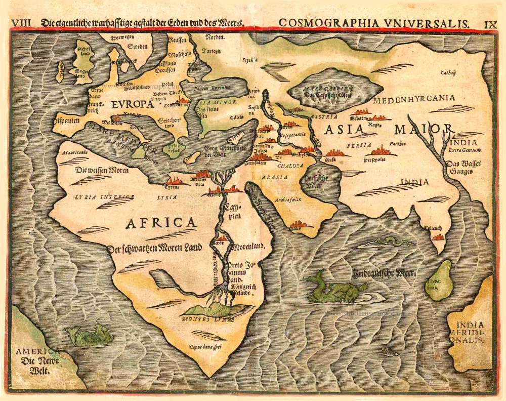
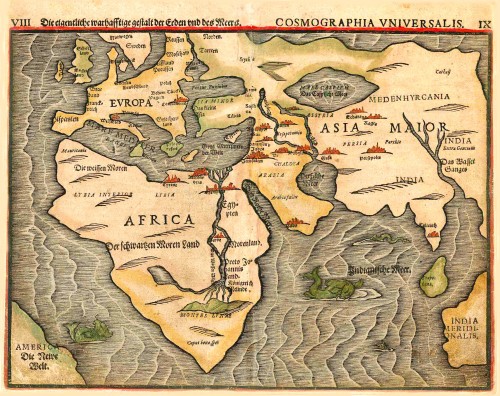

This is one of ten maps in Bünting's Itinerarium, in which the author, a theological commentator, rewrote the Bible as an illustrated travel book. Other maps in the series bear out his imaginative approach to cartography, which pictures the World in the form of a cloverleaf, Europe as the Queen of the World, and Asia as Pegasus.
Heinrich Bünting (Hannover, 1545-1606)
Heinrich Bünting was a protestant pastor and theologian. He was also a brewer in Hannover, and he was concerned with history and wrote a Braunschweigische Chronica in 1584. His main work was the popular Itinerarium Sacrae Scripturae, which after the first edition in Magdeburg in 1581 had many editions in German, Latin, Dutch, Swedish, Danish, Czech and English.
The book gave an overview of biblical geography based on the travel descriptions of various notable people from the Old and New Testaments. It contained ten woodcut maps, including three figurative maps: the world depicted as a cloverleaf with Jerusalem in the centre, Europe in the shape of a crowned woman, and Asia as the winged horse Pegasus.
Die eigentliche und warhafftige gestalt der Erden und des Meers.
Item Number: 26562 Authenticity Guarantee
Category: Antique maps > World
Old, antique world map, by H. Bünting.
Second world map of Bünting's Itinerarium. America appears in the lower left-hand corner.
Date of the first edition: 1581
Date of this map: 1581
Woodcut
Size: 27.5 x 36.5cm (10.7 x 14.2 inches)
Verso text: German
Condition: Original coloured, centrefold restored.
Condition Rating: C
References: Shirley (World), 143; Clancy, p.66 Map 5.8.
From: Itinerarium Sacrae Scriptura . . . Magdeburg, 1581- ....
This is one of ten maps in Bünting's Itinerarium, in which the author, a theological commentator, rewrote the Bible as an illustrated travel book. Other maps in the series bear out his imaginative approach to cartography, which pictures the World in the form of a cloverleaf, Europe as the Queen of the World, and Asia as Pegasus.
This is one of ten maps in Bünting's Itinerarium, in which the author, a theological commentator, rewrote the Bible as an illustrated travel book. Other maps in the series bear out his imaginative approach to cartography, which pictures the World in the form of a cloverleaf, Europe as the Queen of the World, and Asia as Pegasus.
Heinrich Bünting (Hannover, 1545-1606)
Heinrich Bünting was a protestant pastor and theologian. He was also a brewer in Hannover, and he was concerned with history and wrote a Braunschweigische Chronica in 1584. His main work was the popular Itinerarium Sacrae Scripturae, which after the first edition in Magdeburg in 1581 had many editions in German, Latin, Dutch, Swedish, Danish, Czech and English.
The book gave an overview of biblical geography based on the travel descriptions of various notable people from the Old and New Testaments. It contained ten woodcut maps, including three figurative maps: the world depicted as a cloverleaf with Jerusalem in the centre, Europe in the shape of a crowned woman, and Asia as the winged horse Pegasus.
