
World map as a double hemisphere, by Joan Blaeu. 1658
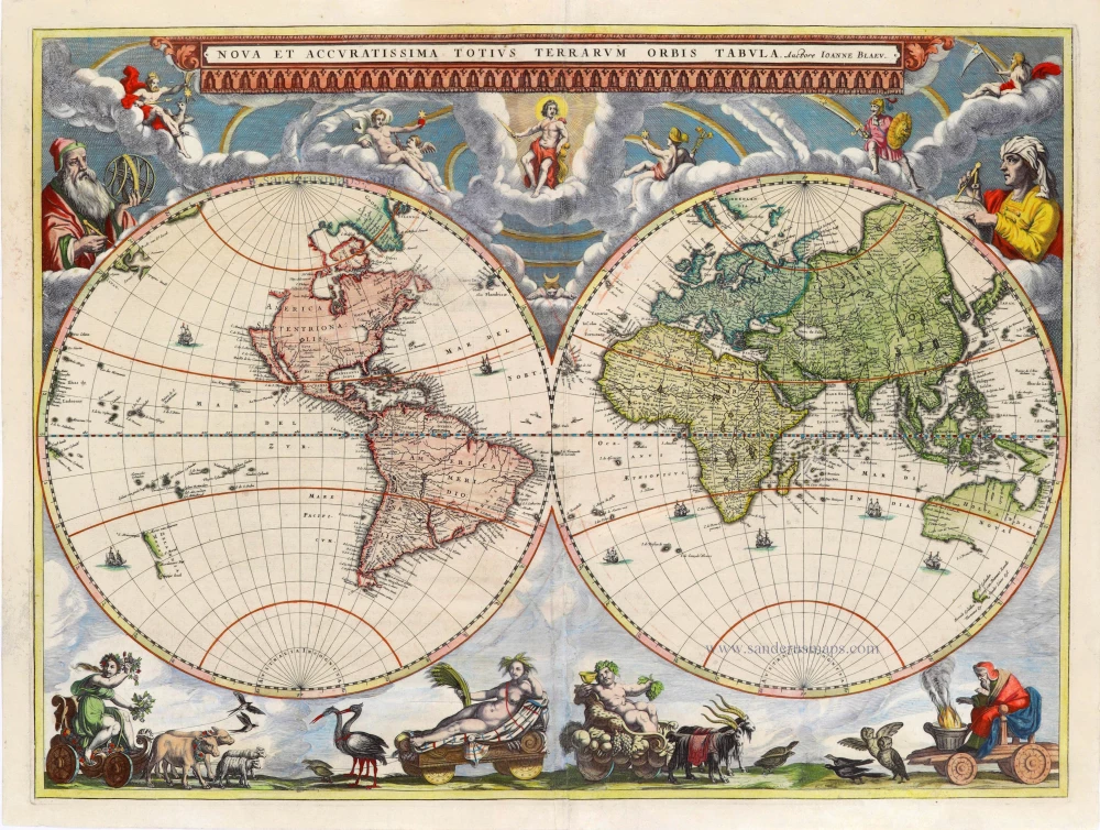


Old, antique world map, as a double hemisphere, by Joan Blaeu.
This highly decorative world map is adorned with allegorical figures along the bottom depicting the four seasons, celestial figures along the top, and portraits of the astronomers Galileo Galilei in the upper left and Tycho Brahe in the upper right.
The new world map prepared by Joan Blaeu for his eleven-volume Atlas Major in 1662 is, unlike its predecessor, in two hemispheres. It is not directly taken from the large original of 1648 but is copied from one of his competitor's reductions, perhaps that by Nicolaas Visscher. The particular outline of California, the inclusion of Nova Albion, Pt.Sr. Franco Draco and part of Anian are features not found on the large 1648 map.
As with all productions by the firm of Blaeu, the engraving and layout and elegance of decoration are all of the highest standards. The map is invariably printed on quality thick paper and often superbly hand-coloured. Outside the twin hemispheres at the top are celestial figures seated amid clouds; below are representations of the four seasons, with each allegorical figure seated in an appropriate chariot quaintly drawn by pairs of beasts and birds. (Shirley)
The Blaeus: Willem Janszoon, Cornelis & Joan
Willem Jansz. Blaeu and his son Joan Blaeu are the seventeenth century's most widely known cartographic publishers.
Willem Jansz. (also written Guilielmus Janssonius) = Willem Janszoon Blaeu was born in Uitgeest (Netherlands), near Alkmaar, in 1571. He studied mathematics under Tycho Brahe and learned the theory and practice of astronomical observations and the art of instrument- and globe-making.
In 1596, he came to Amsterdam, where he settled down as a globe-, instrument- and map-maker. He published his first cartographic work (a globe) in 1599 and probably published his first printed map (a map of the Netherlands) in 1604. He specialised in maritime cartography, published the first edition of the pilot guide Het Licht der Zeevaert in 1608, and was appointed Hydrographer of the V.O.C. (United East India Company) in 1633. After publishing books, wall maps, globes, charts and pilot guides for thirty years, he brought out his first atlas, Atlas Appendix (1630). This was the beginning of the great tradition of atlas-making by the Blaeus.
In 1618, another mapmaker, bookseller and publisher, Johannes Janssonius, established himself in Amsterdam next door to Blaeu's shop. No wonder these two neighbours began accusing each other of copying and stealing their information and became fierce competitors who did not have a good word to say about each other. In about 1621 Willem Jansz. decided to end the confusion between his name and his competitor's and assumed his grandfather's nickname, 'blauwe Willem' ('blue Willem'), as the family name; after that, he called himself Willem Jansz. Blaeu.
Willem Janszoon Blaeu died in 1638, leaving his prospering business to his sons, Cornelis and Joan. We only know that Cornelis's name occurs in the prefaces of books and atlases until c. 1645.
Joan Blaeu, born in Amsterdam in 1596, became a partner in his father’s book trade and printing business. 1638, he was appointed his father’s successor in the Hydrographic Office of the V.O.C. His efforts culminated in the magnificent Atlas Major and the town books of the Netherlands and Italy – works unsurpassed in history and modern times, giving eternal fame to the name of the Blaeu's.
On February 23, 1672, a fire ruined the business. One year later, Dr Joan Blaeu died. The fire of 1672 and the passing away of the director gave rise to a complete sale of the stock of the Blaeu House. Five public auctions dispersed the remaining books, atlases, copperplates, globes, etc., among many other map dealers and publishers in Amsterdam. The majority was acquired by several booksellers acting in partnership.
In the succeeding years, the remaining printing department was left in the hands of the Blaeu family until 1695, when the printing house's inventory was sold at a public auction. That meant the end of the Blaeu's as a printing house of world renown.
Nova Et Accuratissima Totius Terrarum Orbis Tabula.
Item Number: 28084 Authenticity Guarantee
Category: Antique maps > World and Polar
Old, antique world map, as a double hemisphere, by Joan Blaeu.
Title: Nova Et Accuratissima Totius Terrarum Orbis Tabula.
Auctore Ioanne Blaeu.
Date of the first edition: 1658.
Date of this map: 1658.
Copper engraving, printed on paper.
Size (not including margins): 400 x 540mm (15.75 x 21.26 inches).
Verso: Spanish text.
Condition: Original coloured, heightened in gold, centrefold restored, tear along centrefold running 16 cm into the image (restored), flattened.
Condition Rating: B.
References: Shirley (World) 428, pl.315; Van der Krogt 2, 0001:2B; Baynton-Williams New Worlds, p.96.
From: Atlas Nuevo de la Extrema Asia. 1658-59 (Van der Krogt 2, 641)
Old, antique world map, as a double hemisphere, by Joan Blaeu.
This highly decorative world map is adorned with allegorical figures along the bottom depicting the four seasons, celestial figures along the top, and portraits of the astronomers Galileo Galilei in the upper left and Tycho Brahe in the upper right.
The new world map prepared by Joan Blaeu for his eleven-volume Atlas Major in 1662 is, unlike its predecessor, in two hemispheres. It is not directly taken from the large original of 1648 but is copied from one of his competitor's reductions, perhaps that by Nicolaas Visscher. The particular outline of California, the inclusion of Nova Albion, Pt.Sr. Franco Draco and part of Anian are features not found on the large 1648 map.
As with all productions by the firm of Blaeu, the engraving and layout and elegance of decoration are all of the highest standards. The map is invariably printed on quality thick paper and often superbly hand-coloured. Outside the twin hemispheres at the top are celestial figures seated amid clouds; below are representations of the four seasons, with each allegorical figure seated in an appropriate chariot quaintly drawn by pairs of beasts and birds. (Shirley)
The Blaeus: Willem Janszoon, Cornelis & Joan
Willem Jansz. Blaeu and his son Joan Blaeu are the seventeenth century's most widely known cartographic publishers.
Willem Jansz. (also written Guilielmus Janssonius) = Willem Janszoon Blaeu was born in Uitgeest (Netherlands), near Alkmaar, in 1571. He studied mathematics under Tycho Brahe and learned the theory and practice of astronomical observations and the art of instrument- and globe-making.
In 1596, he came to Amsterdam, where he settled down as a globe-, instrument- and map-maker. He published his first cartographic work (a globe) in 1599 and probably published his first printed map (a map of the Netherlands) in 1604. He specialised in maritime cartography, published the first edition of the pilot guide Het Licht der Zeevaert in 1608, and was appointed Hydrographer of the V.O.C. (United East India Company) in 1633. After publishing books, wall maps, globes, charts and pilot guides for thirty years, he brought out his first atlas, Atlas Appendix (1630). This was the beginning of the great tradition of atlas-making by the Blaeus.
In 1618, another mapmaker, bookseller and publisher, Johannes Janssonius, established himself in Amsterdam next door to Blaeu's shop. No wonder these two neighbours began accusing each other of copying and stealing their information and became fierce competitors who did not have a good word to say about each other. In about 1621 Willem Jansz. decided to end the confusion between his name and his competitor's and assumed his grandfather's nickname, 'blauwe Willem' ('blue Willem'), as the family name; after that, he called himself Willem Jansz. Blaeu.
Willem Janszoon Blaeu died in 1638, leaving his prospering business to his sons, Cornelis and Joan. We only know that Cornelis's name occurs in the prefaces of books and atlases until c. 1645.
Joan Blaeu, born in Amsterdam in 1596, became a partner in his father’s book trade and printing business. 1638, he was appointed his father’s successor in the Hydrographic Office of the V.O.C. His efforts culminated in the magnificent Atlas Major and the town books of the Netherlands and Italy – works unsurpassed in history and modern times, giving eternal fame to the name of the Blaeu's.
On February 23, 1672, a fire ruined the business. One year later, Dr Joan Blaeu died. The fire of 1672 and the passing away of the director gave rise to a complete sale of the stock of the Blaeu House. Five public auctions dispersed the remaining books, atlases, copperplates, globes, etc., among many other map dealers and publishers in Amsterdam. The majority was acquired by several booksellers acting in partnership.
In the succeeding years, the remaining printing department was left in the hands of the Blaeu family until 1695, when the printing house's inventory was sold at a public auction. That meant the end of the Blaeu's as a printing house of world renown.

