
Unrecorded as a wall map. - World map by Cornelis Danckerts and Melchior Tavernier. 1628

Wall map of the world, printed on two sheets and mounted with an accompanying text. The map is the joint effort of Cornelis Danckerts from Amsterdam and the Parisian Melchior Tavernier. Tavernier dedicates the map to the King of France, and the title says that it has been corrected by the latest discoveries of the English, Dutch, etc.
This is the most up to date world map of its time and the oldest extant cartographical evidence of Carstensz's expedition (1623) on a printed map. Thus only five years after the expedition, its results had reached Paris.
The text is composed by N. Durret and is dated 1639. It is titled "Traitté Succint des pricipes De La Geographie" and describes some general geographic aspects.
On the eastern hemisphere, a large south-land appears, where four names are included from Carstensz's expedition.
Our map is the only one known with text, mounted as a wall map with wooden rollers.
Shirley says that about four or five copies of this map survive: British Library; Library of Congres; Paris, Bibl. Nat.; Amsterdam, Univ. Library.
The Danckerts Family.
The Danckerts family of Amsterdam was one of the best-known print and map sellers in 17th century Amsterdam. Their business activity covered a vast period, from ca. 1633. From 1669 until 1701, father Justus and his sons had their shop in the ‘Calverstraet in de Danckbaerheyt’.
Cornelis Danckerts (1561-1631) was a printseller born in Amsterdam and active in Antwerp.
Cornelis Danckerts, the elder (1603-1656) was an engraver and publisher in Amsterdam and Nieuwendijk. Son of Cornelis (above), whom he succeeded in 1631.
The house of Danckerts gained its greatest fame from Justus Danckerts (1635-1701 - son of Cornelis the elder) and his two sons, Theodorus and Cornelis. Dancker Danckerts (1634-1666), the elder brother of Justus, was known for his etchings of paintings, maps, and publications.
The grandfather, father, and sons were highly skilled and excellent artistic drafters and engravers. They are famous for the edition of their Atlas, which appeared from ca. 1686, and for several monumental and beautiful wall maps and views. However, compared with that published by the Blaeu's or Janssonius's, their cartographic work has attracted little attention and has never received proper recognition.
On 14 August 1684, Justus and his sons obtained the privilege from the States of Holland for their publications. In 1713, twelve years after Justus Danckerts, the heirs decided to sell part of the stock of maps and atlases and many copperplates. In 1727, after the death of the last surviving brother Theodorus, a final sale took place.
Jean Baptiste Tavernier (1605-1789)
Brother of Melchior. Began as a bookseller 'sur le quai de l'Horloge aux Trois Estoiles' à Paris. Became later a merchant, diplomat and traveller in Turkey, Persia, central Asia and the East Indies.
Charte Universelle De Tout Le Monde.
Item Number: 28682 Authenticity Guarantee
Category: Antique maps > World
Old, antique world map in two hemispheres., by Cornelis Danckerts and Melchior Tavernier.
Title: Charte Universelle De Tout Le Monde.
En laquelle plusieurs regions sont representees plus exactement quaux precedentes & les terres nouvellement descouvertes fidellement corrigees sur les dernieres relations des Anglois Hollandois et autres
Par Corneille Danckertz et Melchior Tavernier
A Paris chez Melchior Tavernier, graveur et Imprimeur du Roy pour les Tailles douces deme en l'Isle du Palais.
A° 1628.
Date of the first edition: 1628.
Date of this map: 1628.
Date on map: 1628.
Copper engraving, printed from two plates on two sheets of paper, joined, backed with linen.
Map size: 510 x 910mm (20.08 x 35.83 inches).
Size including accompanying text: 720 x 1310mm (28.35 x 51.57 inches).
Condition: A few small professional restorations, small portions of the added text reinstated in facsimile, original coloured but retouched in places. Backed with linen. Original wooden rollers.
An early seventeenth-century wall map in good condition.
Separate publication.
Wall map of the world, printed on two sheets and mounted with an accompanying text. The map is the joint effort of Cornelis Danckerts from Amsterdam and the Parisian Melchior Tavernier. Tavernier dedicates the map to the King of France, and the title says that it has been corrected by the latest discoveries of the English, Dutch, etc.
This is the most up to date world map of its time and the oldest extant cartographical evidence of Carstensz's expedition (1623) on a printed map. Thus only five years after the expedition, its results had reached Paris.
The text is composed by N. Durret and is dated 1639. It is titled "Traitté Succint des pricipes De La Geographie" and describes some general geographic aspects.
On the eastern hemisphere, a large south-land appears, where four names are included from Carstensz's expedition.
Our map is the only one known with text, mounted as a wall map with wooden rollers.
Shirley says that about four or five copies of this map survive: British Library; Library of Congres; Paris, Bibl. Nat.; Amsterdam, Univ. Library.
The Danckerts Family.
The Danckerts family of Amsterdam was one of the best-known print and map sellers in 17th century Amsterdam. Their business activity covered a vast period, from ca. 1633. From 1669 until 1701, father Justus and his sons had their shop in the ‘Calverstraet in de Danckbaerheyt’.
Cornelis Danckerts (1561-1631) was a printseller born in Amsterdam and active in Antwerp.
Cornelis Danckerts, the elder (1603-1656) was an engraver and publisher in Amsterdam and Nieuwendijk. Son of Cornelis (above), whom he succeeded in 1631.
The house of Danckerts gained its greatest fame from Justus Danckerts (1635-1701 - son of Cornelis the elder) and his two sons, Theodorus and Cornelis. Dancker Danckerts (1634-1666), the elder brother of Justus, was known for his etchings of paintings, maps, and publications.
The grandfather, father, and sons were highly skilled and excellent artistic drafters and engravers. They are famous for the edition of their Atlas, which appeared from ca. 1686, and for several monumental and beautiful wall maps and views. However, compared with that published by the Blaeu's or Janssonius's, their cartographic work has attracted little attention and has never received proper recognition.
On 14 August 1684, Justus and his sons obtained the privilege from the States of Holland for their publications. In 1713, twelve years after Justus Danckerts, the heirs decided to sell part of the stock of maps and atlases and many copperplates. In 1727, after the death of the last surviving brother Theodorus, a final sale took place.
Jean Baptiste Tavernier (1605-1789)
Brother of Melchior. Began as a bookseller 'sur le quai de l'Horloge aux Trois Estoiles' à Paris. Became later a merchant, diplomat and traveller in Turkey, Persia, central Asia and the East Indies.
Related items

A fine ornate example of the decorative cartography of the time.
Nova Totius Terrarum Orbis Geographica ac Hydrographica Tabula. Auct: Henr: Hondio. 1641
Double-hemisphere world map by Henricus Hondius.
[Item number: 28768]
Luxury colouring.
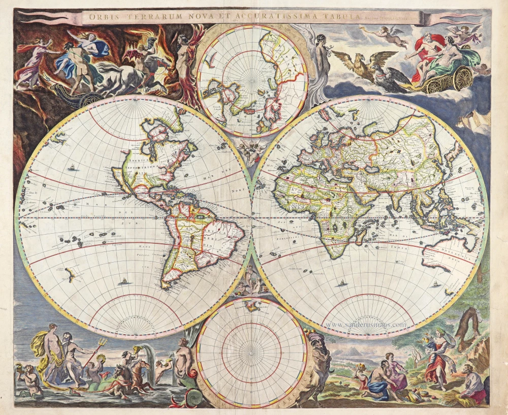
Orbis Terrarum Nova et Accuratissima Tabula. c. 1678
Double-hemisphere world map, by Nicolaas Visscher I.
[Item number: 28934]