
Exceptional example and first complete edition of the Parergon
Ortelius Abraham, historical atlas. 1603


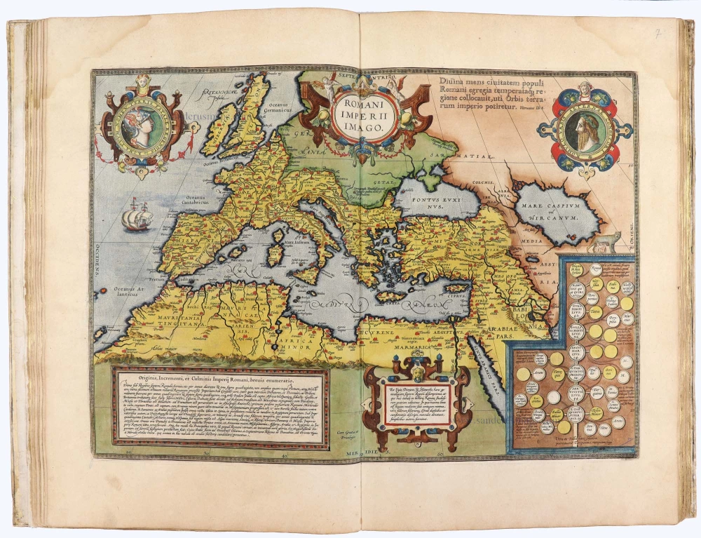


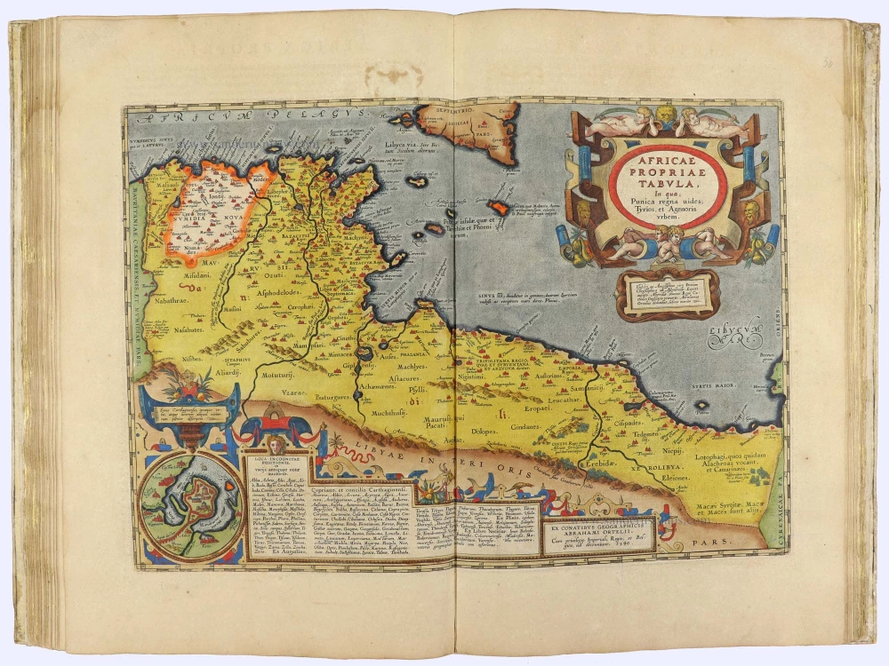


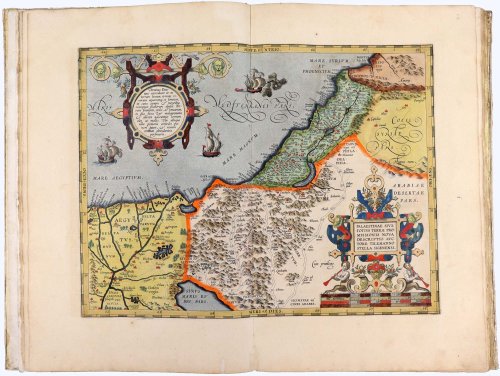


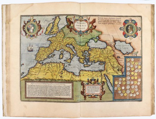

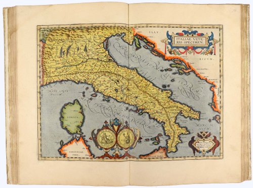


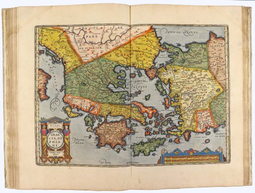

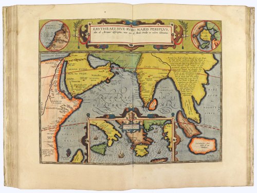

This is a superb example of Ortelius' grand atlas of ancient geography. The Parergon first appeared as a small supplement in the 1579 editions of Ortelius' Theatrum, featuring just three maps of the ancient world. Over time, the map count grew and by 1603, the Parergon had 38 plates. The atlas was published as a supplement to the Theatrum Orbis Terrarum, but also as a separate book. Unlike the maps in the Theatrum, which Ortelius copied from other sources, the Parergon is an entirely original work and a project that Ortelius took great care in executing. Koeman remarked that "the maps and plates in the Parergon have to be evaluated as the most outstanding engravings depicting the widespread interest in classical geography in the 16th century."
Abraham Ortelius (1527-1598)
The maker of the 'first atlas', the Theatrum Orbis Terrarum (1570), was born on 4 April 1527 into an old Antwerp family. He learned Latin and studied Greek and mathematics.
Abraham and his sisters, Anne and Elizabeth, took up map colouring. Ortelius was admitted to the Guild of St. Luke as an "illuminator of maps." In addition to colouring maps, Ortelius was a dealer in antiques, coins, maps, and books, and the book and map trade gradually became his primary occupation.
Business went well because his means allowed him to amass an extensive collection of medals, coins, and antiques, as well as a library of many volumes. In addition, he travelled extensively, visited Italy and France, made contacts with scholars and editors everywhere, and maintained extensive correspondence with them.
In 1564, he published his first map, a large and ambitious world wall map. The inspiration for this map may well have been Gastaldi's large world map. In 1565, he published a map of Egypt and a map of the Holy Land; a large map of Asia followed.
In 1568, the production of individual maps for his atlas Theatrum Orbis Terrarum was already in full swing. He completed the atlas in 1569, and in May 1570, it was available for sale. It was one of the most expensive books ever published.
This first edition contained seventy maps on fifty-three sheets. Franciscus Hogenberg engraved the maps.
Later editions included Additamenta (additions), resulting in Ortelius' historical atlas, the Parergon, which is mainly bound together with the atlas. The Parergon can be considered a truly original work by Ortelius, who drew the maps based on his research.
The importance of the Theatrum Orbis Terrarum for geographical knowledge in the last quarter of the sixteenth century is difficult to overemphasise. Nothing was like it until Mercator's atlas appeared twenty-five years later. Demand for the Theatrum was remarkable. Some 24 editions appeared during Ortelius's lifetime, and another 10 after he died in 1598. Editions were published in Dutch, German, French, Spanish, English, and Italian. The number of map sheets grew from 53 in 1570 to 167 in the last edition in 1612.
In 1577, engraver Philip Galle and poet-translator Pieter Heyns published the first pocket-sized edition of the Theatrum, the Epitome. The work was trendy. Over thirty editions of this Epitome were published in different languages.
Ortelius is also remembered for an early idea resembling continental drift: he suggested that the Americas, Europe, and Africa may once have been joined together before separating over time. His work helped shape the development of modern geography and mapmaking.
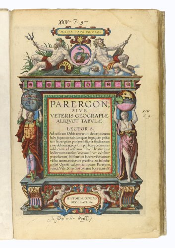
Parergon, sive Veteris Geograpiae Aliquot Tabulae. Lecto S. - Historiae Oculus Geographia. [with:] Nomenclator Ptolemaicus; Omnia Locorum Vocabula quae in Tota Ptolemaei Geographia occurrunt, continens: ad fidem Graeci codicis purgatus & in ordinem non minus utilem quam elegantem digestus.
Item Number: 32084 Authenticity Guarantee
Ortelius A. Parergon, sive Veteris Geograpiae aliquot Tabulae. Lecto S. - Historiae Oculus Geographia. [Antwerp, J.B. Vrientius, 1603] [with:] Nomenclator Ptolemaicus; Omnia Locorum Vocabula quae in Tota Ptolemaei Geographia occurrunt, continens: ad fidem Graeci codicis purgatus & in ordinem non minus utilem quam elegantem digestus. Antverpiae, Typis Roberti Bruneau M.DCIII [1603].
Engraved architectural title-page, three leaves of preliminary matter and 38 double-page engraved maps and plates, all fully coloured in a contemporary hand. bound with: Nomenclator Ptolemaicus. Letterpress sectional title with hand-colored engraved cartographic device, 30, [5] pages. Folio, 46x31 cm, contemporary Dutch vellum binding with a few minor repairs, a few pages with light waterstaining in the upper corners.
A superb example of Ortelius's Parergon in exceptional full original colour. The present example of this atlas of ancient and classical geography, along with the Nomenclator Ptolemaicus, aligns with the appendix to the 1603 Latin edition of Ortelius's Theatrum, but is presented here as an independent work. "In its final state, the Parergon was published as a separate book by Balthasar Moretus in 1624. Separate editions of an earlier date occur less frequently" (Koeman).
Ref.: Van der Krogt III.A 31:041
This is a superb example of Ortelius' grand atlas of ancient geography. The Parergon first appeared as a small supplement in the 1579 editions of Ortelius' Theatrum, featuring just three maps of the ancient world. Over time, the map count grew and by 1603, the Parergon had 38 plates. The atlas was published as a supplement to the Theatrum Orbis Terrarum, but also as a separate book. Unlike the maps in the Theatrum, which Ortelius copied from other sources, the Parergon is an entirely original work and a project that Ortelius took great care in executing. Koeman remarked that "the maps and plates in the Parergon have to be evaluated as the most outstanding engravings depicting the widespread interest in classical geography in the 16th century."
Abraham Ortelius (1527-1598)
The maker of the 'first atlas', the Theatrum Orbis Terrarum (1570), was born on 4 April 1527 into an old Antwerp family. He learned Latin and studied Greek and mathematics.
Abraham and his sisters, Anne and Elizabeth, took up map colouring. Ortelius was admitted to the Guild of St. Luke as an "illuminator of maps." In addition to colouring maps, Ortelius was a dealer in antiques, coins, maps, and books, and the book and map trade gradually became his primary occupation.
Business went well because his means allowed him to amass an extensive collection of medals, coins, and antiques, as well as a library of many volumes. In addition, he travelled extensively, visited Italy and France, made contacts with scholars and editors everywhere, and maintained extensive correspondence with them.
In 1564, he published his first map, a large and ambitious world wall map. The inspiration for this map may well have been Gastaldi's large world map. In 1565, he published a map of Egypt and a map of the Holy Land; a large map of Asia followed.
In 1568, the production of individual maps for his atlas Theatrum Orbis Terrarum was already in full swing. He completed the atlas in 1569, and in May 1570, it was available for sale. It was one of the most expensive books ever published.
This first edition contained seventy maps on fifty-three sheets. Franciscus Hogenberg engraved the maps.
Later editions included Additamenta (additions), resulting in Ortelius' historical atlas, the Parergon, which is mainly bound together with the atlas. The Parergon can be considered a truly original work by Ortelius, who drew the maps based on his research.
The importance of the Theatrum Orbis Terrarum for geographical knowledge in the last quarter of the sixteenth century is difficult to overemphasise. Nothing was like it until Mercator's atlas appeared twenty-five years later. Demand for the Theatrum was remarkable. Some 24 editions appeared during Ortelius's lifetime, and another 10 after he died in 1598. Editions were published in Dutch, German, French, Spanish, English, and Italian. The number of map sheets grew from 53 in 1570 to 167 in the last edition in 1612.
In 1577, engraver Philip Galle and poet-translator Pieter Heyns published the first pocket-sized edition of the Theatrum, the Epitome. The work was trendy. Over thirty editions of this Epitome were published in different languages.
Ortelius is also remembered for an early idea resembling continental drift: he suggested that the Americas, Europe, and Africa may once have been joined together before separating over time. His work helped shape the development of modern geography and mapmaking.