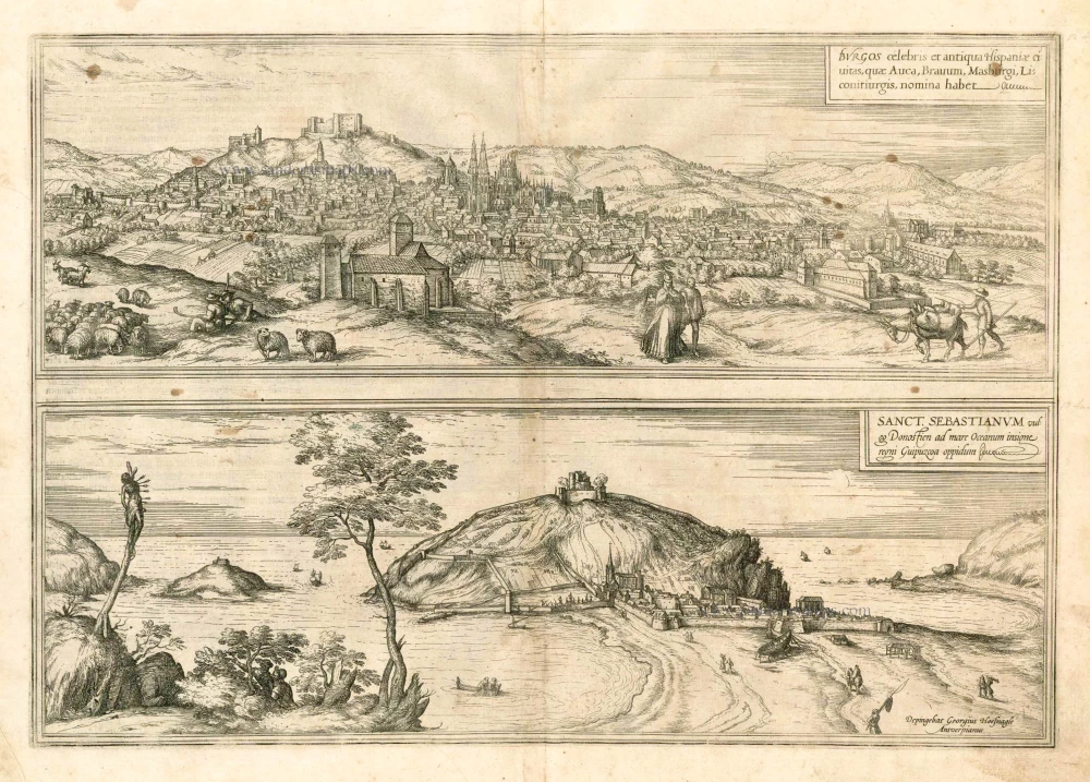
Burgos and San Sebastian by Georg Braun & Frans Hogenberg, after Georg Hoefnagel. 1582
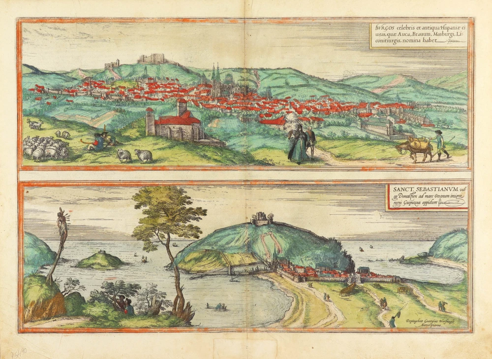


BURGOS
The engraving has probably been made after a drawing by Anton van de Wyngaerde.
TRANSLATION OF CARTOUCHE TEXT: Burgos, a famous old city in Spain, which also has the names Auca, Pravum Masburgum, Liconitiurgis.
COMMENTARY BY BRAUN: "The inhabitants of this city are no idlers or vagrants, but all, men and women alike, earn their living from the work of their own hands; they are honest folk who devote themselves to handicraft and to the arts. The merchants, who multiply the city's wealth, are honest and also generous. The largest church is wondrously designed, both inside and out; inside it, divine service is celebrated at Communion, with singers and organs in five different chapels, none disturbing the other."
Burgos was developed as a stronghold against the Moors from AD 884. In 932, it became the county's capital, and in 1037 the Kingdom of Castile. Burgos lies like an amphitheatre on a hill on the right bank of the Arlazón. The ruined citadel, the former fortress of the kings of Castile, can be clearly seen in the picture. Rising above the city is the vast Gothic cathedral. The city's commercial activities centred upon wool, cheese and cloth production, industries to which the artist refers in his staffage. By the time the Civitates Orbis Terrarum came to be published, Burgos's situation had taken a turn for the worse and Braun's text was no longer wholly accurate. In 1565 the city was namely struck by the plague, which claimed the lives of almost half its population, and economic setbacks and migration further weakened the town over a prolonged period. Burgos, or more accurately Vivar 7 km away, is the birthplace of the Spanish national hero El Cid, who distinguished himself in the battle against the Moors in the 11th century.
SAN SEBASTIÁN
The engraving was made after a drawing by Georg Hoefnagel.
CARTOUCHE: San Sebastián, commonly known as Donostia, on the Atlantic, is an important town in the province of Guipúzcoa.
COMMENTARY BY BRAUN: "This town is very famous for its wide harbour, in which ships find a safe anchorage during stormy seas and strong winds. Since it was built not by the hard work and skill of man but by the careful hand of Nature, it is well known amongst many German merchants, above all, however, amongst the Cantabrian merchants who transport all sorts of wares here and also export them again. The town also possesses fertile fields for producing grain, wine and wool. The Pyrenees begin four Spanish miles away."
San Sebastián's favourable seaside location on the Bay of La Concha (The Shell), in the north of the Iberian Peninsula between Monte Igueldo and Monte Urgull with the small rocky Island on Santa Clara, is clearly illustrated in the engraving. The town's buildings appear cramped, and no details can be identified. Nevertheless, the view shows San Sebastián after its reconstruction; in January 1489, a blaze had namely destroyed almost all the buildings in the town, which had been constructed chiefly of wood. Having been rebuilt, the city subsequently became the base of the Cantabrian armada. On a rocky outcrop on the left-hand edge of the picture is the martyred figure of St Sebastian, from whom the town takes its name. (Taschen)
Braun G. & Hogenberg F. and the Civitates Orbis Terrarum.
The Civitates Orbis Terrarum, also known as the 'Braun & Hogenberg', is a six-volume town atlas and the most excellent book of town views and plans ever published: 363 engravings, sometimes beautifully coloured. It was one of the best-selling works in the last quarter of the 16th century. Georg Braun, a skilled writer, wrote the text accompanying the plans and views on the verso. Many plates were engraved after the original drawings of a professional artist, Joris Hoefnagel (1542-1600). The first volume was published in Latin in 1572 and the sixth in 1617. Frans Hogenberg, a talented engraver, created the tables for volumes I through IV, and Simon van den Neuwel made those for volumes V and VI. Other contributors were cartographers Daniel Freese and Heinrich Rantzau, who provided valuable geographical information. Works by Jacob van Deventer, Sebastian Münster, and Johannes Stumpf were also used as references. Translations appeared in German and French, making the atlas accessible to a wider audience.
Since its original publication of volume 1 in 1572, the Civitates Orbis Terrarum has left an indelible mark on the history of cartography. The first volume was followed by seven more editions in 1575, 1577, 1582, 1588, 1593, 1599, and 1612. Vol.2, initially released in 1575, saw subsequent editions in 1597 and 1612. The subsequent volumes, each a treasure trove of historical insights, graced the world in 1581, 1588, 1593, 1599, and 1606. The German translation of the first volume, a testament to its widespread appeal, debuted in 1574, followed by the French edition in 1575.
Several printers were involved: Theodor Graminaeus, Heinrich von Aich, Gottfried von Kempen, Johannis Sinniger, Bertram Buchholtz, and Peter von Brachel, all of whom worked in Cologne.
Georg Braun (1541-1622)
Georg Braun, the author of the text accompanying the plans and views in the Civitates Orbis Terrarum, was born in Cologne in 1541. After his studies in Cologne, he entered the Jesuit Order as a novice, indicating his commitment to learning and intellectual pursuits. In 1561, he obtained his bachelor's degree; in 1562, he received his Magister Artium, further demonstrating his academic achievements. Although he left the Jesuit Order, he continued his studies in theology, gaining a licentiate in theology. His theological background likely influenced the content and tone of the text in the Civitates Orbis Terrarum, adding a unique perspective to the work.
Frans Hogenberg (1535-1590)
Frans Hogenberg was a Flemish and German painter, engraver, and mapmaker. He was born in Mechelen as the son of Nicolaas Hogenberg.
By the end of the 1560s, Frans Hogenberg was employed upon Abraham Ortelius's Theatrum Orbis Terrarum, published in 1570; he is named an engraver of numerous maps. In 1568, he was banned from Antwerp by the Duke of Alva and travelled to London, where he stayed a few years before emigrating to Cologne. He immediately embarked on his two most important works, the Civitates, published in 1572 and the Geschichtsblätter, which appeared in several series from 1569 until about 1587.
Thanks to large-scale projects like the Geschichtsblätter and the Civitates, Hogenberg's social circumstances improved with each passing year. He died as a wealthy man in Cologne in 1590.
Burgos celebris et antiqua Hispaniae civitas, quae Auca, Brauum, Masburgi, Liconitiurgis, nomina habet. [on sheet with] Sanct. Sebastianum vulgo Donosien ad Occanum insigne regni Guipuzcoa oppidum.
Item Number: 25490 Authenticity Guarantee
Category: Antique maps > Europe > Spain and Portugal
Two antique bird’s-eye views of Burgos and San Sebastian by Georg Braun & Frans Hogenberg, after Georg Hoefnagel.
Title: Burgos celebris et antiqua Hispaniae civitas, quae Auca, Brauum, Masburgi, Liconitiurgis, nomina habet. [on sheet with] Sanct. Sebastianum vulgo Donosien ad Occanum insigne regni Guipuzcoa oppidum.
Depingebat Georgius Hoefnagle Antverpianus.
Date of the first edition: 1572.
Date of this map: 1582.
Copper engraving, printed on paper.
Map size: 328 x 470mm (12.91 x 18.5 inches).
Sheet size: 380 x 515mm (14.96 x 20.28 inches).
Verso: Latin text.
Condition: Original coloured, excellent.
Condition Rating: A+.
From: Civitates Orbis Terrarum, Liber Primus. Köln, Gottfried von Kempen, 1582. (Van der Krogt 4, 41:1.1(1582))
BURGOS
The engraving has probably been made after a drawing by Anton van de Wyngaerde.
TRANSLATION OF CARTOUCHE TEXT: Burgos, a famous old city in Spain, which also has the names Auca, Pravum Masburgum, Liconitiurgis.
COMMENTARY BY BRAUN: "The inhabitants of this city are no idlers or vagrants, but all, men and women alike, earn their living from the work of their own hands; they are honest folk who devote themselves to handicraft and to the arts. The merchants, who multiply the city's wealth, are honest and also generous. The largest church is wondrously designed, both inside and out; inside it, divine service is celebrated at Communion, with singers and organs in five different chapels, none disturbing the other."
Burgos was developed as a stronghold against the Moors from AD 884. In 932, it became the county's capital, and in 1037 the Kingdom of Castile. Burgos lies like an amphitheatre on a hill on the right bank of the Arlazón. The ruined citadel, the former fortress of the kings of Castile, can be clearly seen in the picture. Rising above the city is the vast Gothic cathedral. The city's commercial activities centred upon wool, cheese and cloth production, industries to which the artist refers in his staffage. By the time the Civitates Orbis Terrarum came to be published, Burgos's situation had taken a turn for the worse and Braun's text was no longer wholly accurate. In 1565 the city was namely struck by the plague, which claimed the lives of almost half its population, and economic setbacks and migration further weakened the town over a prolonged period. Burgos, or more accurately Vivar 7 km away, is the birthplace of the Spanish national hero El Cid, who distinguished himself in the battle against the Moors in the 11th century.
SAN SEBASTIÁN
The engraving was made after a drawing by Georg Hoefnagel.
CARTOUCHE: San Sebastián, commonly known as Donostia, on the Atlantic, is an important town in the province of Guipúzcoa.
COMMENTARY BY BRAUN: "This town is very famous for its wide harbour, in which ships find a safe anchorage during stormy seas and strong winds. Since it was built not by the hard work and skill of man but by the careful hand of Nature, it is well known amongst many German merchants, above all, however, amongst the Cantabrian merchants who transport all sorts of wares here and also export them again. The town also possesses fertile fields for producing grain, wine and wool. The Pyrenees begin four Spanish miles away."
San Sebastián's favourable seaside location on the Bay of La Concha (The Shell), in the north of the Iberian Peninsula between Monte Igueldo and Monte Urgull with the small rocky Island on Santa Clara, is clearly illustrated in the engraving. The town's buildings appear cramped, and no details can be identified. Nevertheless, the view shows San Sebastián after its reconstruction; in January 1489, a blaze had namely destroyed almost all the buildings in the town, which had been constructed chiefly of wood. Having been rebuilt, the city subsequently became the base of the Cantabrian armada. On a rocky outcrop on the left-hand edge of the picture is the martyred figure of St Sebastian, from whom the town takes its name. (Taschen)
Braun G. & Hogenberg F. and the Civitates Orbis Terrarum.
The Civitates Orbis Terrarum, also known as the 'Braun & Hogenberg', is a six-volume town atlas and the most excellent book of town views and plans ever published: 363 engravings, sometimes beautifully coloured. It was one of the best-selling works in the last quarter of the 16th century. Georg Braun, a skilled writer, wrote the text accompanying the plans and views on the verso. Many plates were engraved after the original drawings of a professional artist, Joris Hoefnagel (1542-1600). The first volume was published in Latin in 1572 and the sixth in 1617. Frans Hogenberg, a talented engraver, created the tables for volumes I through IV, and Simon van den Neuwel made those for volumes V and VI. Other contributors were cartographers Daniel Freese and Heinrich Rantzau, who provided valuable geographical information. Works by Jacob van Deventer, Sebastian Münster, and Johannes Stumpf were also used as references. Translations appeared in German and French, making the atlas accessible to a wider audience.
Since its original publication of volume 1 in 1572, the Civitates Orbis Terrarum has left an indelible mark on the history of cartography. The first volume was followed by seven more editions in 1575, 1577, 1582, 1588, 1593, 1599, and 1612. Vol.2, initially released in 1575, saw subsequent editions in 1597 and 1612. The subsequent volumes, each a treasure trove of historical insights, graced the world in 1581, 1588, 1593, 1599, and 1606. The German translation of the first volume, a testament to its widespread appeal, debuted in 1574, followed by the French edition in 1575.
Several printers were involved: Theodor Graminaeus, Heinrich von Aich, Gottfried von Kempen, Johannis Sinniger, Bertram Buchholtz, and Peter von Brachel, all of whom worked in Cologne.
Georg Braun (1541-1622)
Georg Braun, the author of the text accompanying the plans and views in the Civitates Orbis Terrarum, was born in Cologne in 1541. After his studies in Cologne, he entered the Jesuit Order as a novice, indicating his commitment to learning and intellectual pursuits. In 1561, he obtained his bachelor's degree; in 1562, he received his Magister Artium, further demonstrating his academic achievements. Although he left the Jesuit Order, he continued his studies in theology, gaining a licentiate in theology. His theological background likely influenced the content and tone of the text in the Civitates Orbis Terrarum, adding a unique perspective to the work.
Frans Hogenberg (1535-1590)
Frans Hogenberg was a Flemish and German painter, engraver, and mapmaker. He was born in Mechelen as the son of Nicolaas Hogenberg.
By the end of the 1560s, Frans Hogenberg was employed upon Abraham Ortelius's Theatrum Orbis Terrarum, published in 1570; he is named an engraver of numerous maps. In 1568, he was banned from Antwerp by the Duke of Alva and travelled to London, where he stayed a few years before emigrating to Cologne. He immediately embarked on his two most important works, the Civitates, published in 1572 and the Geschichtsblätter, which appeared in several series from 1569 until about 1587.
Thanks to large-scale projects like the Geschichtsblätter and the Civitates, Hogenberg's social circumstances improved with each passing year. He died as a wealthy man in Cologne in 1590.