
Abyssinia (Ethiopia) by Coronelli V.M. (1650-1718 1691
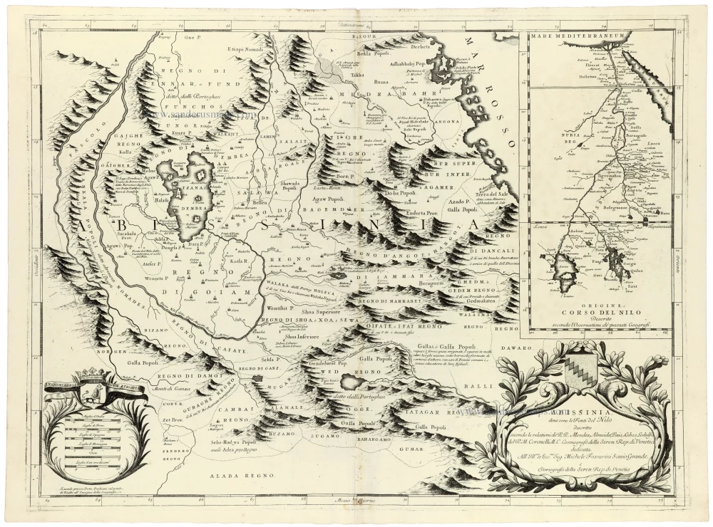
A historically significant map of Abyssinia and the upper Nile, distinguished by its extensive topographical detail and its fascinating representation of the Nile's sources, one of the great geographical questions of the early modern world.
The map depicts the Ethiopian Highlands and the extensive territories traditionally associated with the Kingdom of Abyssinia, extending towards Nubia and the Nile Valley in the west and the Red Sea in the east. Numerous kingdoms, provinces, settlements, rivers and mountain ranges are identified, reflecting the geographical knowledge of the region available to European scholars during the late seventeenth century.
Particular attention is devoted to the sources of the Nile, one of the great geographical mysteries of the ancient and early modern world. The map prominently features Lake Tana, shown as a large, irregular lake in the western Ethiopian Highlands, along with the surrounding river systems. The Blue Nile, known in Ethiopia as the Abay, flows from the lake and eventually joins the White Nile at Khartoum.
Coronelli's representation draws upon the geographical and historical accounts of European travellers, missionaries and scholars, including the Portuguese Jesuit Manuel de Almeida and the Spanish Jesuit Pedro Páez, whose observations contributed significantly to European knowledge of Ethiopia and the upper Nile.
The map is particularly remarkable for its extensive depiction of the Ethiopian Highlands, represented by numerous pictorial mountain ranges. These are interspersed with the names of local kingdoms and provinces, including Amhara, Tigray, Gojjam, Damot and other historical territories.
An inset map in the upper right corner, entitled Origine e Corso del Nilo, illustrates the supposed origin and course of the Nile from its upper reaches through Nubia and Egypt to the Mediterranean Sea. This supplementary map offers an interesting comparison between Abyssinia's relatively detailed geography and contemporary European understanding of the entire Nile system.
The map features two large decorative cartouches. The title cartouche in the lower right corner is surrounded by elaborate foliage and surmounted by a heraldic shield. A second cartouche in the lower left contains several distance scales and another coat of arms.
Coronelli was one of the most accomplished cartographers of the Italian Baroque period. As Cosmographer to the Republic of Venice and founder of the Accademia Cosmografica degli Argonauti, he produced numerous important maps, atlases and globes, distinguished by their geographical detail and elaborate decorative engraving.
Published during a period of growing European interest in the geography and history of northeastern Africa, this map synthesises contemporary geographical knowledge, historical tradition, and scientific speculation about the sources of the Nile.
Vincenzo Coronelli (1650-1718)
Vincenzo Coronelli was born in Venice on 16 August 1650 and primarily brought up in Ravenna. He returned to Venice in 1665 and joined the convent of the Minor Conventuals. Five years later, he was sent to Rome to study, and by 1673, he was already a doctor of theology.
Having achieved fame by constructing two globes for the Duke of Parma, he was invited to Paris for three years in 1681 and made two enormous examples for Louis XIV. On his return to Venice, he assiduously collected cartographic material and founded the Academy of the Argonauts. In 1685, he was appointed Cosmographer to the Republic of Venice and authorised to publish a large atlas. He became a geography lecturer at the University of Venice and brought out an Atlante Veneto the following year.
In 1696, he visited Germany, Holland and southern England. During intervals in compiling his vast encyclopaedia, he continued with cartographic projects up to 1709. He died in his native Venice on 9 December 1718.
Coronelli became famous for his globes. In addition, he was a renowned encyclopaedist, mapmaker and geographer. Most of his maps and other material are gathered in his Atlante Veneto (13 vols, 1690-1705). The first volume, subtitled Descrizione generale istorica geografica, was his masterpiece, planned as an extension of Blaeu’s atlas.
Other volumes of the atlas which contain maps are Isolario, two parts (1696-8), with detailed maps and plans, mostly of islands; Corso geografico, two parts based on the edition 1694-7; Libro de’ globi (1697); and Lo Specchio del Mare, a reprint of Levanto's Lo Specchio del Mare Mediterraneo of 1664.
The other vital aspects of his mapping are those arising from the Venetian conquest and his travels. His most extensive military compilation was the Teatro della Guerra, in more than 30 volumes.
Abissinia dove sono le Fonti del Nilo
Item Number: 33372 new Authenticity Guarantee
Category: Antique maps > Africa
Abyssinia (Ethiopia) by Coronelli V.M.
With an inset map of the course of the Nile.
Title: Abissinia dove sono le Fonti del Nilo
descritta secondo le relationi de P.P. Mendez, Almeida, Païs, Lobo, e Lodulfo, del P.M. Coronelli M.C. Cosmografo della Seren. Rep. di Venetia, ...
Date of the first edition: 1691.
Date of this map: 1691.
Copper engraving, printed on paper.
Image size: 450 x 600mm (17¾ x 23½ inches).
Sheet size: 475 x 645mm (18¾ x 25½ inches).
Verso: Blank.
Condition: Excellent.
Condition Rating: A+.
From: Atlante Veneto, nel quale si contiene la descrittione... degl' Imperii, Regni, Provincie, e Stati dell' Universo. Venice: Girolamo Albrizzi, 1691. Shirley (Brit.Lib.), T.CORO-7a
A historically significant map of Abyssinia and the upper Nile, distinguished by its extensive topographical detail and its fascinating representation of the Nile's sources, one of the great geographical questions of the early modern world.
The map depicts the Ethiopian Highlands and the extensive territories traditionally associated with the Kingdom of Abyssinia, extending towards Nubia and the Nile Valley in the west and the Red Sea in the east. Numerous kingdoms, provinces, settlements, rivers and mountain ranges are identified, reflecting the geographical knowledge of the region available to European scholars during the late seventeenth century.
Particular attention is devoted to the sources of the Nile, one of the great geographical mysteries of the ancient and early modern world. The map prominently features Lake Tana, shown as a large, irregular lake in the western Ethiopian Highlands, along with the surrounding river systems. The Blue Nile, known in Ethiopia as the Abay, flows from the lake and eventually joins the White Nile at Khartoum.
Coronelli's representation draws upon the geographical and historical accounts of European travellers, missionaries and scholars, including the Portuguese Jesuit Manuel de Almeida and the Spanish Jesuit Pedro Páez, whose observations contributed significantly to European knowledge of Ethiopia and the upper Nile.
The map is particularly remarkable for its extensive depiction of the Ethiopian Highlands, represented by numerous pictorial mountain ranges. These are interspersed with the names of local kingdoms and provinces, including Amhara, Tigray, Gojjam, Damot and other historical territories.
An inset map in the upper right corner, entitled Origine e Corso del Nilo, illustrates the supposed origin and course of the Nile from its upper reaches through Nubia and Egypt to the Mediterranean Sea. This supplementary map offers an interesting comparison between Abyssinia's relatively detailed geography and contemporary European understanding of the entire Nile system.
The map features two large decorative cartouches. The title cartouche in the lower right corner is surrounded by elaborate foliage and surmounted by a heraldic shield. A second cartouche in the lower left contains several distance scales and another coat of arms.
Coronelli was one of the most accomplished cartographers of the Italian Baroque period. As Cosmographer to the Republic of Venice and founder of the Accademia Cosmografica degli Argonauti, he produced numerous important maps, atlases and globes, distinguished by their geographical detail and elaborate decorative engraving.
Published during a period of growing European interest in the geography and history of northeastern Africa, this map synthesises contemporary geographical knowledge, historical tradition, and scientific speculation about the sources of the Nile.
Vincenzo Coronelli (1650-1718)
Vincenzo Coronelli was born in Venice on 16 August 1650 and primarily brought up in Ravenna. He returned to Venice in 1665 and joined the convent of the Minor Conventuals. Five years later, he was sent to Rome to study, and by 1673, he was already a doctor of theology.
Having achieved fame by constructing two globes for the Duke of Parma, he was invited to Paris for three years in 1681 and made two enormous examples for Louis XIV. On his return to Venice, he assiduously collected cartographic material and founded the Academy of the Argonauts. In 1685, he was appointed Cosmographer to the Republic of Venice and authorised to publish a large atlas. He became a geography lecturer at the University of Venice and brought out an Atlante Veneto the following year.
In 1696, he visited Germany, Holland and southern England. During intervals in compiling his vast encyclopaedia, he continued with cartographic projects up to 1709. He died in his native Venice on 9 December 1718.
Coronelli became famous for his globes. In addition, he was a renowned encyclopaedist, mapmaker and geographer. Most of his maps and other material are gathered in his Atlante Veneto (13 vols, 1690-1705). The first volume, subtitled Descrizione generale istorica geografica, was his masterpiece, planned as an extension of Blaeu’s atlas.
Other volumes of the atlas which contain maps are Isolario, two parts (1696-8), with detailed maps and plans, mostly of islands; Corso geografico, two parts based on the edition 1694-7; Libro de’ globi (1697); and Lo Specchio del Mare, a reprint of Levanto's Lo Specchio del Mare Mediterraneo of 1664.
The other vital aspects of his mapping are those arising from the Venetian conquest and his travels. His most extensive military compilation was the Teatro della Guerra, in more than 30 volumes.
Related items
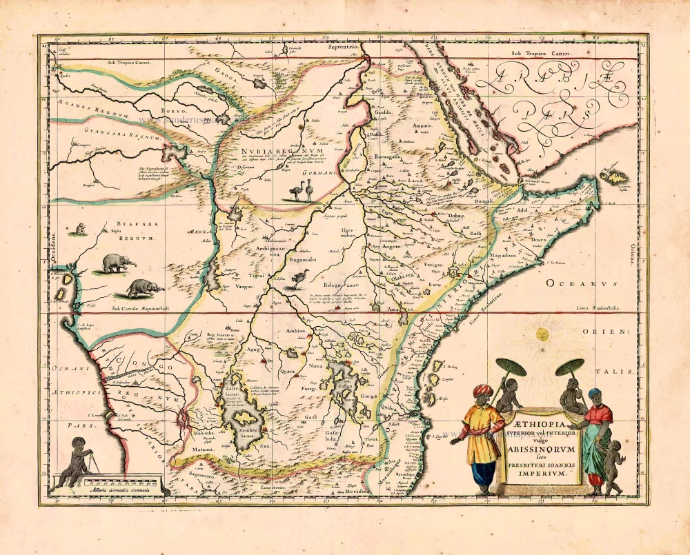
Aethiopia Superior vel Interior; vulgo Abissinorum sive Presbiteri Ioannis Imperium. 1640
Kingdom of Prester John, by Willem Blaeu.
[Item number: 27693]

Ptolemaic map of the African continent
[Title on verso:] Tabula .IIII. Aphricae. 1525
Africa, by Lorenz Fries,
[Item number: 27976]

Haute Ethiopie, ou sont l'Empire des Abissins, La Nubie, et le Zanguebar. 1658
Central and eastern Africa by Nicolas Sanson
[Item number: 28437]

Carte Particuliere de l'Egypte, de la Nubie et de l'Abyssinie. 1719
Northeast Africa & Arabia, by Z. Châtelain.
[Item number: 29371]

Luxury colouring with gold
De Cust van Barbaria, Gualata, Arguyn, en Genheo, van Capo S. Vicente tot Capo Verde 1666
North-West African Coast by Pieter Goos.
[Item number: 33067]