
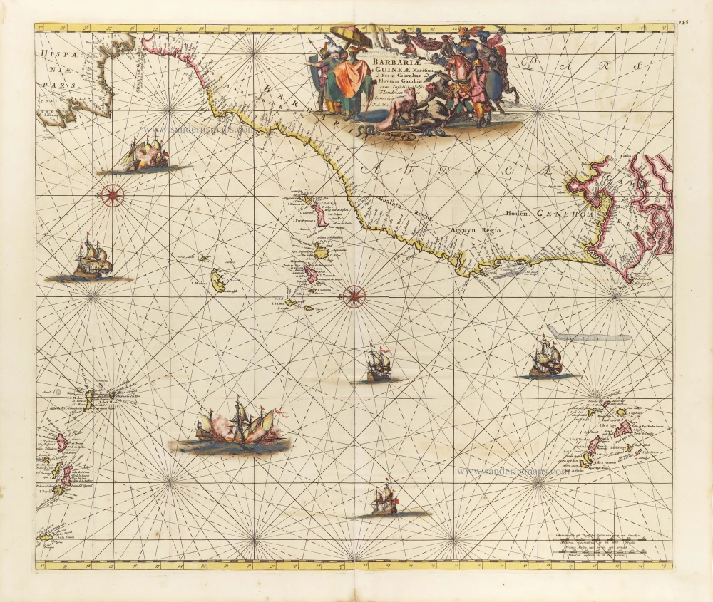
Northern Atlantic Coast of Africa, by Frederick de Wit. c. 1691-97


Frederick de Wit (1630-1706)
The engraver and map-seller, Frederick de Wit, was born in Gouda (Netherlands) in 1630 as a son of Hendrick Fredericksz de Wit. Through his marriage with Maria van der Waag of Amsterdam in 1661, he obtained citizenship of the city where he had been working since 1648 and where he became one of the most famous engravers of maps of the second half of the 17th century. Although De Wit was a Catholic, which meant that he was not favoured at the time by the city council, he was awarded the honour of being listed as one of the "excellent citizens" on the roll of the city council in the years 1694-1704. However, his name was not written in the Guild of St. Luke book before 1664. At that time, he lived on the Kalverstraat "in de Witte Pascaert", where he stayed until his death in 1706. His earliest dates on maps engraved are 1659 (Regni Daniae) and 1660 (World map).
Frederick de Wit published several world atlases, a sea atlas, and an atlas of the Netherlands.
The dating of the maps is difficult. However, as a privilege was granted in 1689, the annotation 'cum privilegio' marks an edition after 1688.
Around 1700, Frederick de Wit entered the market with a town atlas. He produced two volumes with a total of 260 plans and views. Most were printed from plates used for Janssonius and Blaeu town atlases.
After he died in 1706, his widow continued the shop until 1709. The plates and stock of De Wit's atlas were sold to Covens & Mortier in 1710, who sold the atlas for an extended period.
Barbariae et Guineae Maritimi à Freto Gibralter ad Fluvium Gambiae cum Insulis Salsis Flandricis et Canaricis.
Item Number: 29278 Authenticity Guarantee
Category: Antique maps > Africa
Old, antique sea chart of Northern Atlantic Coast of Africa, with the Azores and Cape Verde Islands, by Frederick de Wit.
Title: Barbariae et Guineae Maritimi à Freto Gibralter ad Fluvium Gambiae cum Insulis Salsis Flandricis et Canaricis.
Apud F. de Wit.
Oriented to the east.
Date of the first edition: c. 1671-76.
Date of this map: c. 1691-97.
Copper engraving, printed on paper.
Map size: 485 x 465mm (19.09 x 18.31 inches).
Sheet size: 540 x 630mm (21.26 x 24.8 inches).
Verso: Blank.
Condition: Original coloured, partially backed with archival paper, lower centrefold split reinforced.
Condition Rating: A.
From: Orbis Maritimus ofte Zee Atlas. Amsterdam, F. de Wit, c. 1680.
Frederick de Wit (1630-1706)
The engraver and map-seller, Frederick de Wit, was born in Gouda (Netherlands) in 1630 as a son of Hendrick Fredericksz de Wit. Through his marriage with Maria van der Waag of Amsterdam in 1661, he obtained citizenship of the city where he had been working since 1648 and where he became one of the most famous engravers of maps of the second half of the 17th century. Although De Wit was a Catholic, which meant that he was not favoured at the time by the city council, he was awarded the honour of being listed as one of the "excellent citizens" on the roll of the city council in the years 1694-1704. However, his name was not written in the Guild of St. Luke book before 1664. At that time, he lived on the Kalverstraat "in de Witte Pascaert", where he stayed until his death in 1706. His earliest dates on maps engraved are 1659 (Regni Daniae) and 1660 (World map).
Frederick de Wit published several world atlases, a sea atlas, and an atlas of the Netherlands.
The dating of the maps is difficult. However, as a privilege was granted in 1689, the annotation 'cum privilegio' marks an edition after 1688.
Around 1700, Frederick de Wit entered the market with a town atlas. He produced two volumes with a total of 260 plans and views. Most were printed from plates used for Janssonius and Blaeu town atlases.
After he died in 1706, his widow continued the shop until 1709. The plates and stock of De Wit's atlas were sold to Covens & Mortier in 1710, who sold the atlas for an extended period.
Related items
Nieuwe Paskaert vande Gheheele Westersche Scheep-Vaert, op Nieus uyt Ondervindinghe van Schrandre Stierlieden Naaukeurigh Geteeckent en Samen Gebracht. 1697-1709
The Atlantic Ocean, by J. Van Keulen.
[Item number: 11218]
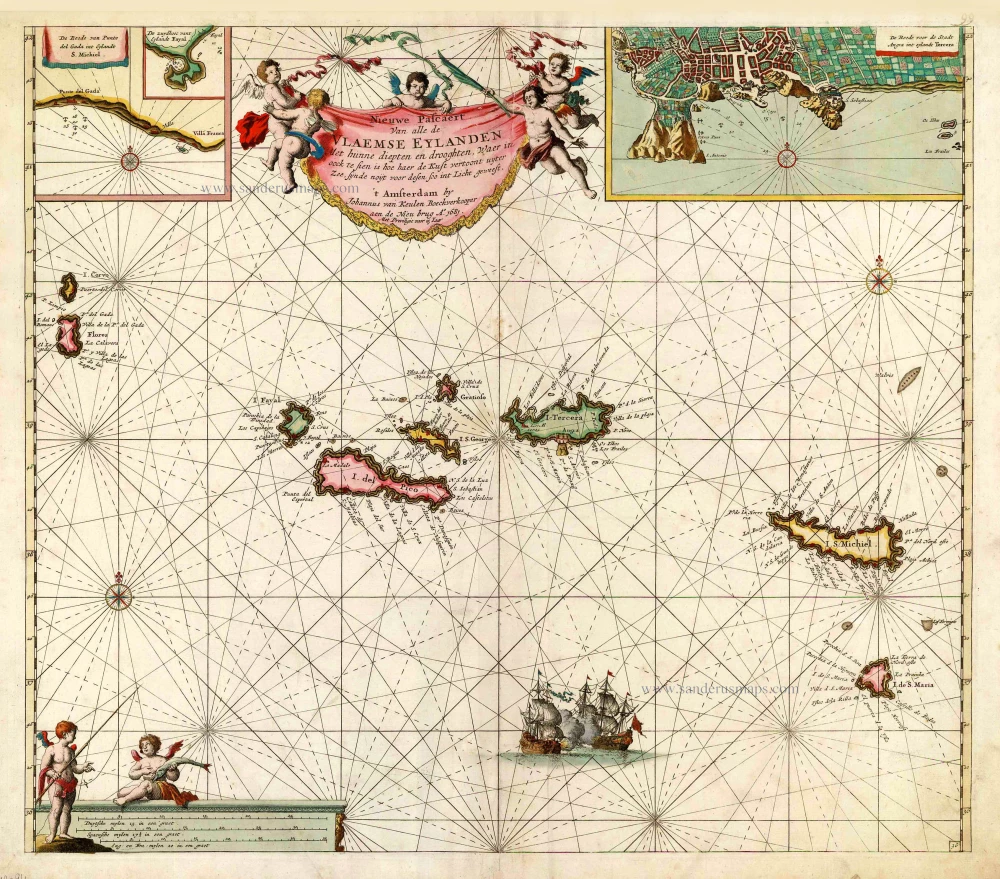
Nieuwe Pascaert van Alle de Vlaemse Eylanden 1681
The Azores, by Johannes Van Keulen.
[Item number: 12094]
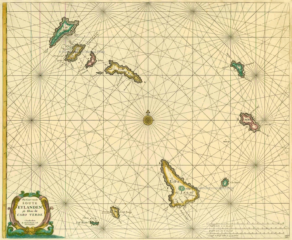
Pas-Caart vande Soute Eylanden ofte Ilhas de Cabo Verde 1686
Cape Verde Islands, by Doncker H.
[Item number: 13643]
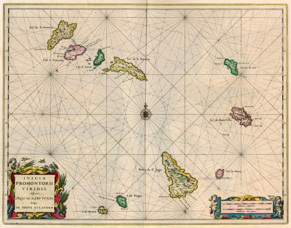
Insulae Promontorii Viridis, Hispanis Islas de Cabo Verde, Belgis de Soute Eylanden 1662
Cape Verde Islands, by Blaeu J.
[Item number: 22816]
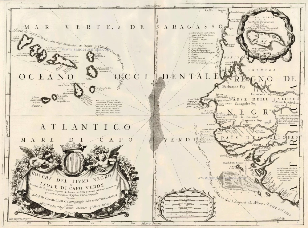
Bocche del Fiume Negro et Isole di Capo Verde 1691
Cape Verde Islands, by Coronelli V.M.
[Item number: 23167]
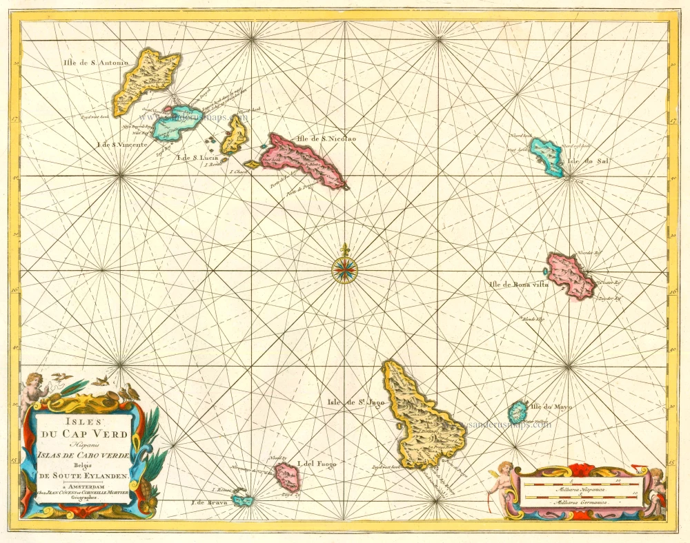
Isles du Cap Verd Hispanis Islas de Cabo Verde Belgis de Soute Eylanden. 1721-41
Cape Verde Islands, by Covens & Mortier.
[Item number: 23621]

Les Iles du Cap Verd, nommées par quelques Auteurs Iles de Sel. 1713
Cape Verde Islands, by Pieter van der Aa.
[Item number: 26164]

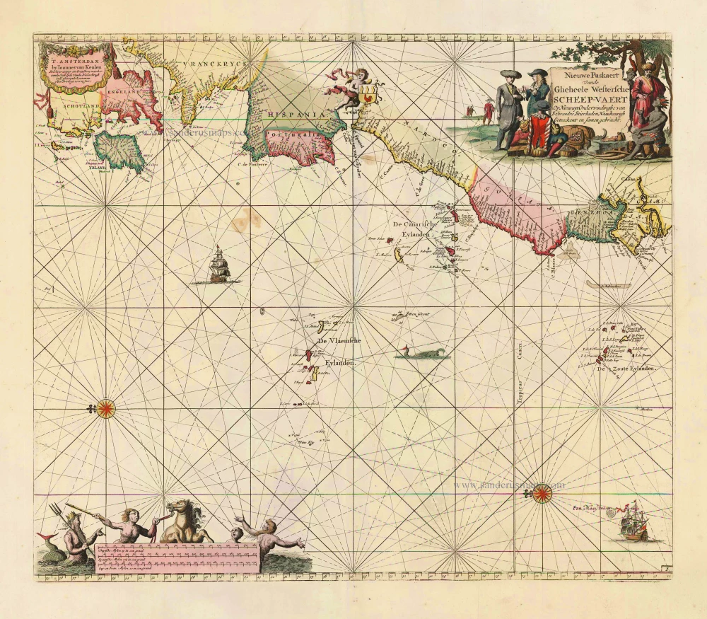
Paskaart van de Cust van Portugal, Barbaria, en Genehoa Beginnende van d'Barlengers tot aan C. Verde. 1680-1694
Sea chart of the northwest coast of Africa, with the Azores, Canary Islands and Cape Verde Islands, by Johannes Van Keulen.
[Item number: 26808]

Carte Réduite des Isles Açores. 1756-1770
The Azores, by J.N. Bellin.
[Item number: 28977]