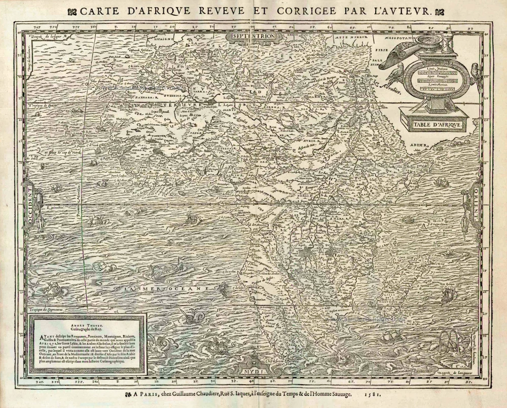
Africa, by A. Thevet 1581
According to Burden, this edition is scarce; he only located six examples. Compared with the 1575 edition, there are no changes to the map's cartography, only the typography.
André Thevet was a Franciscan monk who travelled extensively in Europe and made a reputed short journey to South America. Upon his return, he records that he sailed along the eastern coast of North America. The experiences he recalls of the New World have attracted much criticism from both his contemporaries and recent historians for their inaccuracy. However, one person seemed impressed, the King of France, Henry III, who bestowed him the honour of Royal Cosmographer.
Betz: "This is an important map in the progression of the mapping of Africa. It is the first folio map to show Africa largely based on the Mercator model and not solely that of the Gastaldi-Ortelius model. It is modelled on the Africa section of Gerard Mercator's famous world map of 1569. Following Mercator, a major lake is shown southwest of the traditional twin Ptolemaic Nile source lakes. This third lake, the unnamed Lac Sachaf, is now shown feeding the river system to the south, notably the Cuama and Spirito Santo Rivers. This same lake is the source of the Congo River to the west and flows into the Nile to the north. Above the Niger River in West Africa, Thevet follows Mercator by placing a river, the Gher-Nubie, that flows eastward into the Nile River."
Table d'Afrique. - [Letterpress title above the map:] Carte d'Afrique revue et corrigee par l'auteur.
Item Number: 11215 Authenticity Guarantee
Category: Antique maps > Africa
Old, antique map of Africa by A. Thevet.
Date of the first edition: 1575
Date of this map: 1584
Date on map: 1581
Woodcut
Size (not including margins and title): 35 x 45cm (13.7 x 17.6 inches)
Verso: Blank
Condition: Excellent.
Condition Rating: A+
References: Karrow, 77/5; Betz, 17, Variant A 1581; Norwich, 12; Tooley (Africa), 26
From: Les vrais Portraits et vies des hommes illustres Grecs, Latins, et Payens Receuillis de leur Tableaux, Livres, Medailles antiques, et Modernes Par Andre Thevet Angoumoisin, ... Paris, Par la vefue I. Kervert Et Guillaume Chaudiere, 1584.
According to Burden, this edition is scarce; he only located six examples. Compared with the 1575 edition, there are no changes to the map's cartography, only the typography.
André Thevet was a Franciscan monk who travelled extensively in Europe and made a reputed short journey to South America. Upon his return, he records that he sailed along the eastern coast of North America. The experiences he recalls of the New World have attracted much criticism from both his contemporaries and recent historians for their inaccuracy. However, one person seemed impressed, the King of France, Henry III, who bestowed him the honour of Royal Cosmographer.
Betz: "This is an important map in the progression of the mapping of Africa. It is the first folio map to show Africa largely based on the Mercator model and not solely that of the Gastaldi-Ortelius model. It is modelled on the Africa section of Gerard Mercator's famous world map of 1569. Following Mercator, a major lake is shown southwest of the traditional twin Ptolemaic Nile source lakes. This third lake, the unnamed Lac Sachaf, is now shown feeding the river system to the south, notably the Cuama and Spirito Santo Rivers. This same lake is the source of the Congo River to the west and flows into the Nile to the north. Above the Niger River in West Africa, Thevet follows Mercator by placing a river, the Gher-Nubie, that flows eastward into the Nile River."