
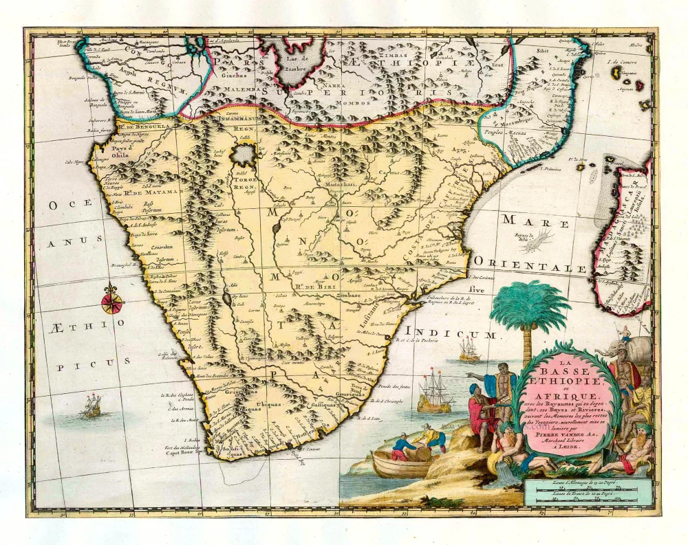
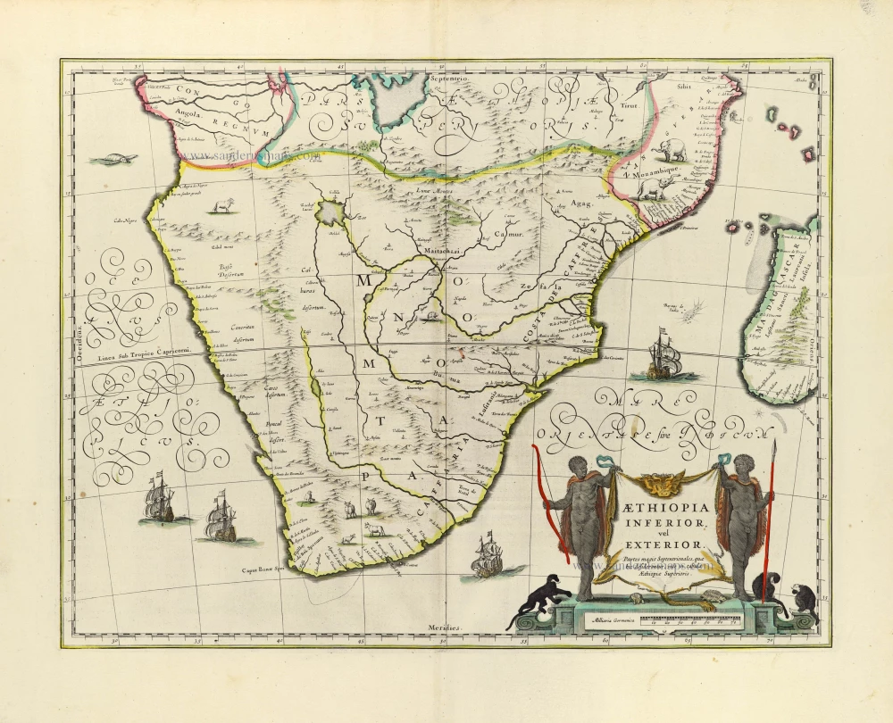
Southern Africa, by Pieter van der Aa. 1713
Pieter van der Aa (Leiden, 1659-1733)
Pieter van der Aa was already in 1682 owner of a bookshop and auction house. During his life, he has published an enormous amount of printed material.
After 1700, van der Aa increasingly specialised in books on geography and travel.
He published composite atlases, a series of geographical descriptions of European countries, and some very spectacular works. Between 1706 and 1708 he published the Naauweurige versameling der gedenkwaardigste zee- en land-reysen, in 28 volumes.
Many of Van der Aa’s publications are richly illustrated with maps and plates. He took over many copperplates and prints from other publishers such as Carel Allard and Frederik De Wit. The composite atlases that appeared from his workshop contain a curious mixture of his own material, copies of maps from other publishers, and reprints made from old copper plates, now with his own imprint.
The Galérie agréable du monde, was completed in 1729, and comprised 66 parts, bound in 27 volumes. Van der Aa presented it as a good investment; after publication, the antiquarian value of the work would double, the more so since it was printed in a limited edition of only one hundred copies.
La Basse Ethiopie, en Afrique, avec les Royaumes qui en dependent, ses Bayes et Rivieres.
Item Number: 26158 Authenticity Guarantee
Category: Antique maps > Africa
Southern Africa, by Pieter van der Aa, after O. Dapper.
Title: La Basse Ethiopie, en Afrique, avec les Royaumes qui en dependent, ses Bayes et Rivieres.
Date of the first edition: 1713.
Date of this map: 1713.
Copper engraving, printed on paper.
Size (not including margins): 280 x 365mm (11.02 x 14.37 inches).
Verso: Blank.
Condition: Original body colour, trimmed to neatline and mounted on heavy paper at an early time.
Condition Rating: A.
From: Nouvel Atlas, très exact et fort commode pour toutes sortes de personnes, Contenant Les Principales cartes géographiques. Leiden, P. Van der Aa, n.d. (1713) (Koeman, Aa7).
Van der Aa maps are rarely found in original colouring.
Pieter van der Aa (Leiden, 1659-1733)
Pieter van der Aa was already in 1682 owner of a bookshop and auction house. During his life, he has published an enormous amount of printed material.
After 1700, van der Aa increasingly specialised in books on geography and travel.
He published composite atlases, a series of geographical descriptions of European countries, and some very spectacular works. Between 1706 and 1708 he published the Naauweurige versameling der gedenkwaardigste zee- en land-reysen, in 28 volumes.
Many of Van der Aa’s publications are richly illustrated with maps and plates. He took over many copperplates and prints from other publishers such as Carel Allard and Frederik De Wit. The composite atlases that appeared from his workshop contain a curious mixture of his own material, copies of maps from other publishers, and reprints made from old copper plates, now with his own imprint.
The Galérie agréable du monde, was completed in 1729, and comprised 66 parts, bound in 27 volumes. Van der Aa presented it as a good investment; after publication, the antiquarian value of the work would double, the more so since it was printed in a limited edition of only one hundred copies.
Related items
No title 1724-26
The South African Coast, by François Valentyn (Valentijn).
[Item number: 17825]
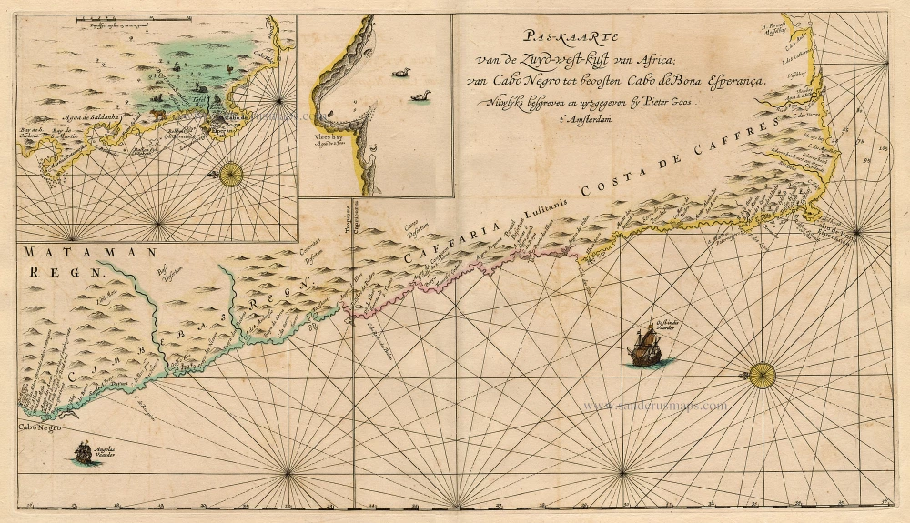
Pas-Kaarte van de Zuyd-West-Kust van Afrika; van Cabo Negro tot Beoosten Cabo de Bona Esperanca 1667
Sea chart of South African Coast, by Pieter Goos.
[Item number: 19073]
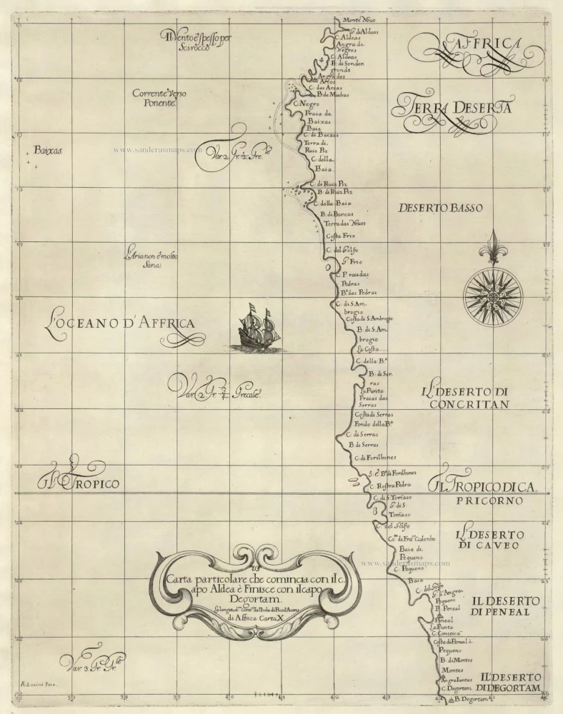
Carta particolare che comincia con il capo Aldea è Finisce con il capo Degortam . . . di Affrica Carta X. 1646-47
The Southwest Coast of Africa, by Sir Robert Dudley.
[Item number: 19843]
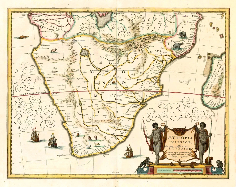
Aethiopia Inferior, vel Exterior. 1641
Johannes Janssonius, Southern Africa.
[Item number: 26450]
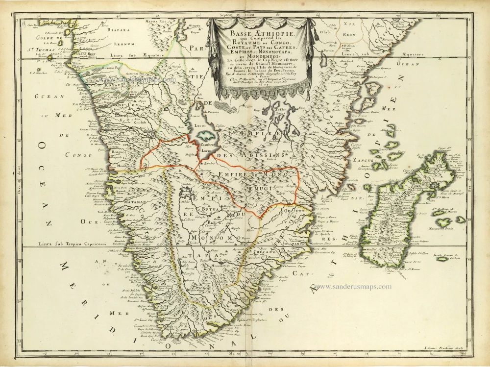
Basse AEthiopie, qui comprend les Royaume de Congo, Coste et Pays des Cafres, Empires du Monomotapa, et Monoemugi. 1658
Southern Africa and Madagascar by Nicolas Sanson.
[Item number: 28436]
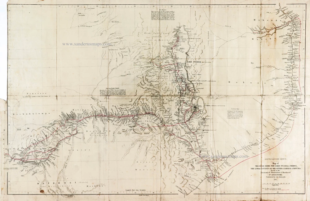
Dr David Livingstone
Map of the River Shire, The Lakes Nyassa, & Shirwa, The Lower Courses of the Rivers Zambesi & Rovuma.
South Eastern Africa by Dr D. Livingstone.
[Item number: 29939]
Aethiopia Inferior, Vel Exterior. 1643
Willem Blaeu, Southern Africa.
[Item number: 30122]

Important map
Typus orarum maritimarum Guineae, Manicongo, & Angolae ... / Afbeeldinghe der custen des landts Guinea, ende Angola, ende voorts tot voorby de C. de boa esperança, ... 1596
West Africa, by Linschoten J.H. van
[Item number: 32214]