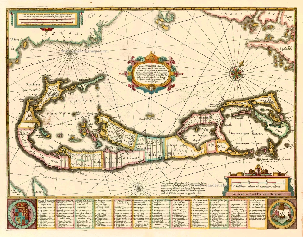
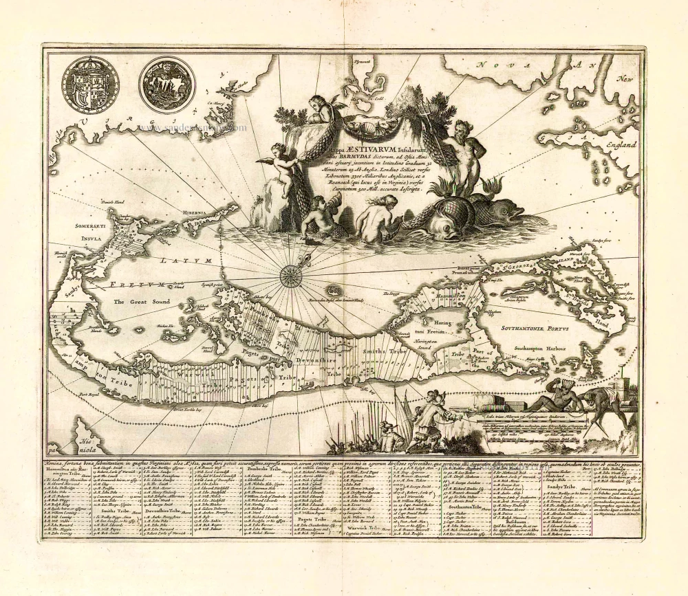
Bermuda, by John Speed. 1646
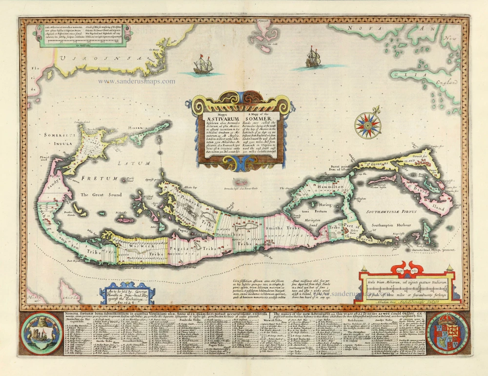
Compiled in 1622 by Norwood, this was the first English printed map in an atlas to show the Island divided into Tribes and lots with "the names of the now Adventurerer, viz. this yeare 1622 so neare as wee could Gather, expressed with numbers that have Reference to their Shares which Shares are there distinguished and severed on the land, as is here represented by lines".
It became the standard map of the 17th century, copied by Blaeu, Janssonius and Ogilby.
John Speed (1551/52 – 1629)
John Speed was an English cartographer and historian.
Initially, he worked in his father's tailoring business. He moved to London in 1567. In 1572, John Speed married Susanna Draper from London, who had 12 sons and six daughters.
Due to his excellent knowledge of history, he became known in influential scientific circles. He joined the Antiquarian Society, where he was encouraged to do research work.
In 1595 he published a four-sheet map of Canaan. In the following years, he worked on a series of maps of English counties and cities, which he would later compile in the atlas The Theater of the Empire of Great Britaine, published in 1612. Because the original engraver William Rogers died in 1604, many of the maps were engraved in Amsterdam by Jodocus Hondius. A pocket edition of the atlas, engraved by Pieter Van den Keere, appeared in 1619.
With their detailed town plans and descriptive texts, Speed's maps filled the needs of the time and quickly replaced the earlier Saxton atlases generally in use until then. Not only were they more up to date, but undoubtedly the beauty of the engraving, the fine lettering and the elaborate ornamentation appealed to the original buyers. As a result of the great success of these atlases, a world atlas appeared in 1627: Prospect Of The Most Famous Parts of the World, with 22 to 28 maps, also engraved in Amsterdam. Many of these maps were issued with decorated borders.
Numerous re-editions of these atlases were published, regularly supplemented with new maps.
He died in 1629, one year after his wife, Susanna.
Mappa Aestivarum Insularum alias Bermudas dictarum, ... | A Mapp of the Sommer Ilands once called the Bermudas ...
Item Number: 28034 Authenticity Guarantee
Category: Antique maps > America > North America
Old, antique map of Bermuda, by John Speed.
Title: Mappa Aestivarum Insularum alias Bermudas dictarum, ... | A Mapp of the Sommer Ilands once called the Bermudas ...
Are to be sold by . George Humble. in Pops-head Alley against the Exchainge - Ano.1626.
Abraham Goos Amstelodamensis sculpsit.
Oriented to the northwest.
Cartographer: Richard Norwood (1590-1675).
Engraver: Abraham Goos (c. 1590-1643)
Date of the first edition: 1626.
Date of this map: 1646.
Date on map: 1626.
Copper engraving, printed on paper.
Size (not including margins): 405 x 535mm (15.94 x 21.06 inches).
Verso: English text.
Condition: Hand coloured, remargined.
Condition Rating: B+
References: Palmer, p. 25-27
From: A Prospect of the Most Famous Parts of the World. Performed by John Speed London Printed by John Dawson for George Humble, and are to be sold at his Shop in Popes-head Pallace. 1646. (Shirley (Brit. Lib.), T.SPE-2c)
Compiled in 1622 by Norwood, this was the first English printed map in an atlas to show the Island divided into Tribes and lots with "the names of the now Adventurerer, viz. this yeare 1622 so neare as wee could Gather, expressed with numbers that have Reference to their Shares which Shares are there distinguished and severed on the land, as is here represented by lines".
It became the standard map of the 17th century, copied by Blaeu, Janssonius and Ogilby.
John Speed (1551/52 – 1629)
John Speed was an English cartographer and historian.
Initially, he worked in his father's tailoring business. He moved to London in 1567. In 1572, John Speed married Susanna Draper from London, who had 12 sons and six daughters.
Due to his excellent knowledge of history, he became known in influential scientific circles. He joined the Antiquarian Society, where he was encouraged to do research work.
In 1595 he published a four-sheet map of Canaan. In the following years, he worked on a series of maps of English counties and cities, which he would later compile in the atlas The Theater of the Empire of Great Britaine, published in 1612. Because the original engraver William Rogers died in 1604, many of the maps were engraved in Amsterdam by Jodocus Hondius. A pocket edition of the atlas, engraved by Pieter Van den Keere, appeared in 1619.
With their detailed town plans and descriptive texts, Speed's maps filled the needs of the time and quickly replaced the earlier Saxton atlases generally in use until then. Not only were they more up to date, but undoubtedly the beauty of the engraving, the fine lettering and the elaborate ornamentation appealed to the original buyers. As a result of the great success of these atlases, a world atlas appeared in 1627: Prospect Of The Most Famous Parts of the World, with 22 to 28 maps, also engraved in Amsterdam. Many of these maps were issued with decorated borders.
Numerous re-editions of these atlases were published, regularly supplemented with new maps.
He died in 1629, one year after his wife, Susanna.