
Carolina, by Pieter (Pierre) Mortier. c. 1696
In 1692 Pierre Mortier had published a Dutch contrefaçon of the Atlas Nouveau by Alexis-Hubert Jaillot. It was issued in partnership with Pierre Huguetan, a French bookseller resident in Amsterdam, who provided considerable financial backing. Their next project was an edition of Jaillot's Neptune François, first published in 1693. Mortier employed the finest engravers and extended the work with the magnificent Cartes Marines à l'usage du Roy de la Grande Bretagne. It contained only nine charts, eight of which were of British waters. They are engraved by Romein de Hooghe, who was the employ of William III at the time, and are arguably the most stunning sea charts produced to date. In 1700, Mortier published a second volume entitled Suite du Neptune François; this covered non-European waters. According to the title, many of the charts were produced from the manuscripts drawn by N.P. d'Ablancourt, a French diplomat in Lisbon, from the Portuguese archives. It was issued simultaneously in French and Dutch. (Burden)
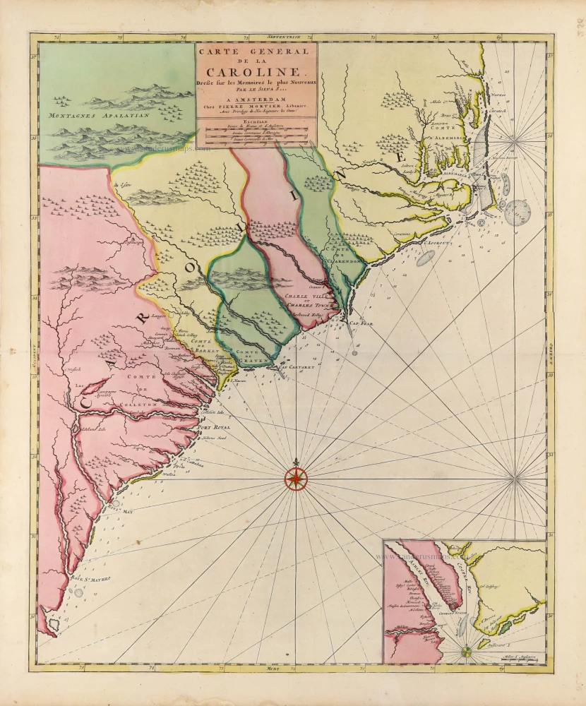
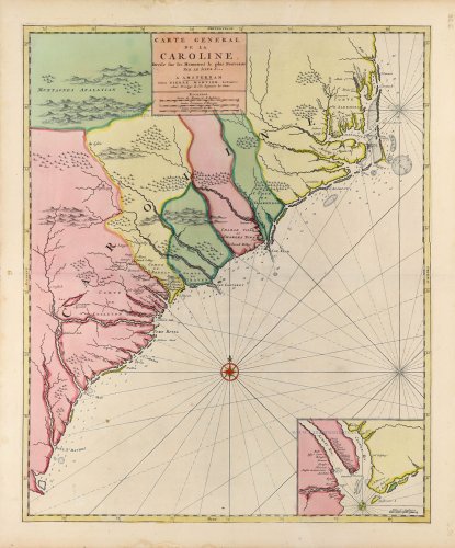
This map covers both of the Carolinas, as we know them today, and is the first map published on the continent. Despite the title stating that it is by Nicolas Sanson, it is, in fact, of English origin, being derived directly from John Thornton, Robert Morden and Philip Lea's A New Map of Carolina, 1685. It is the first map of Carolina published outside of England.
The map is often found bound into examples of Mortier's Atlas Nouveau. It has also been found in composite atlases by Frederick de Wit and the firm of Reiner and Josua Ottens.
Based on the Thornton-Morden-Lea map c. 1685.
Covens & Mortier. A Map Publishing House in Amsterdam. 1721-1866.
During almost two centuries, the largest and most important Dutch publishing house in commercial cartography was the Amsterdam firm of Covens & Mortier. Concerning quantity, it was possibly even the biggest contemporary map-trading house worldwide. They distributed innumerable maps, atlases, globes, and books.
Pieter (Pierre) Mortier (Leiden, 1661 – Amsterdam, 1711)
Nothing is known about the youth of Pieter Mortier. He studied in Paris from 1681 to approximately 1685. There he must have come into contact with French 'libraires' and learned the bookselling trade. Beginning 1685 he returned to Amsterdam where he opened a small bookshop. In the same year, he became a member of the Book, Art Sellers' and Printers' guild.
Pieter sold books in Dutch and foreign languages, but he also published books on his own, usually in the French language. His business flourished such that in 1688 he was already forced to rent another house on the Vijgendam.
Pieter Mortier's first privilege for maps was granted by the States of Holland and West Friesland on September 15 1690. It refers to the maps of Sanson that he 'is printing and correcting with great pains and care'.
Pieter began the large scale publication of maps and atlases. By the beginning of the 18th century, Pieter had become so wealthy that he could purchase three houses in Amsterdam: on the Beurssluis, on the Vijgendam, and the Heremietensteeg. He rebuilt the house on the Vijgendam into a large prestigious house that would serve for over a century as a shop, business, and residential structure for Covens & Mortier's publishing house.
He died on February 13, 1711, after a brief illness. The company continued to exist under Pieter's widow's management, Amelia' s-Gravesande.
After she died in 1719, her son Cornelis, took over the management for a few years.
On November 20, 1721, a company was founded by Cornelis Mortier and Johannes Covens I. The latter was married the same year with Cornelis's sister. From that year on, the name of :
Covens & Mortier.
Their firm would see a massive expansion in the next 140 years. In 1732 the heirs sold the property to their brother Cornelis and his partner Covens. Their main competitors were Reinier & Josua Ottens and Gerard Valck & Petrus Schenck. After the death of Johannes Covens I (1774), his son Johannes Covens II (1722-1794) entered the business. From 1778, Johannes added a new company name :
J. Covens & Son.
Johannes Covens II was succeeded by his son Cornelis Covens (1764-1825), who, in turn, brought Peter Mortier IV, the great-grandson of Petrus Mortier I, into the business. The name was from 1794 to 1866:
Mortier, Covens & Son.
The last Covens in the series was Cornelis Johannes Covens (1806-1880).
Covens & Mortier had a large stock of atlases and maps, including those of: Delisle, Jaillot, Johannes Janssonius, Sanson, Claes Jansz. Visscher, Nicolaas Visscher, and Frederik de Wit. For decades, an impressive number of atlases came from the press.
Carte General de la Caroline.
Item Number: 31417 Authenticity Guarantee
Category: Antique maps > America > North America
Carolina, by Pieter (Pierre) Mortier.
Title: Carte General de la Caroline.
Dreße sur les Memoires le plus Nouveaux | Par le Sieu A S ...
A Amsterdam | Chez Pierre Mortier, Libraire.
Avec privilege de Nos Seigneurs les Etats.
With an inset map of the mouth of the Cooper and the Ashley rivers.
Cartographer: Nicolas Sanson.
Date of the first edition: c. 1696.
Date of this map: c. 1696.
Copper engraving, printed on paper.
Image size: 565 x 465mm (22¼ x 18¼ inches).
Sheet size: 630 x 530mm (24¾ x 20¾ inches).
Verso: Blank.
Condition: Original coloured, excellent.
Condition Rating: A+.
From: Atlas nouveau contenant toutes les parties du monde ... Paris, c. 1696 (Pastoureau, Jaillot F) = Dutch pirated edition by Pierre Mortier, with new maps.
In 1692 Pierre Mortier had published a Dutch contrefaçon of the Atlas Nouveau by Alexis-Hubert Jaillot. It was issued in partnership with Pierre Huguetan, a French bookseller resident in Amsterdam, who provided considerable financial backing. Their next project was an edition of Jaillot's Neptune François, first published in 1693. Mortier employed the finest engravers and extended the work with the magnificent Cartes Marines à l'usage du Roy de la Grande Bretagne. It contained only nine charts, eight of which were of British waters. They are engraved by Romein de Hooghe, who was the employ of William III at the time, and are arguably the most stunning sea charts produced to date. In 1700, Mortier published a second volume entitled Suite du Neptune François; this covered non-European waters. According to the title, many of the charts were produced from the manuscripts drawn by N.P. d'Ablancourt, a French diplomat in Lisbon, from the Portuguese archives. It was issued simultaneously in French and Dutch. (Burden)
This map covers both of the Carolinas, as we know them today, and is the first map published on the continent. Despite the title stating that it is by Nicolas Sanson, it is, in fact, of English origin, being derived directly from John Thornton, Robert Morden and Philip Lea's A New Map of Carolina, 1685. It is the first map of Carolina published outside of England.
The map is often found bound into examples of Mortier's Atlas Nouveau. It has also been found in composite atlases by Frederick de Wit and the firm of Reiner and Josua Ottens.
Based on the Thornton-Morden-Lea map c. 1685.
Covens & Mortier. A Map Publishing House in Amsterdam. 1721-1866.
During almost two centuries, the largest and most important Dutch publishing house in commercial cartography was the Amsterdam firm of Covens & Mortier. Concerning quantity, it was possibly even the biggest contemporary map-trading house worldwide. They distributed innumerable maps, atlases, globes, and books.
Pieter (Pierre) Mortier (Leiden, 1661 – Amsterdam, 1711)
Nothing is known about the youth of Pieter Mortier. He studied in Paris from 1681 to approximately 1685. There he must have come into contact with French 'libraires' and learned the bookselling trade. Beginning 1685 he returned to Amsterdam where he opened a small bookshop. In the same year, he became a member of the Book, Art Sellers' and Printers' guild.
Pieter sold books in Dutch and foreign languages, but he also published books on his own, usually in the French language. His business flourished such that in 1688 he was already forced to rent another house on the Vijgendam.
Pieter Mortier's first privilege for maps was granted by the States of Holland and West Friesland on September 15 1690. It refers to the maps of Sanson that he 'is printing and correcting with great pains and care'.
Pieter began the large scale publication of maps and atlases. By the beginning of the 18th century, Pieter had become so wealthy that he could purchase three houses in Amsterdam: on the Beurssluis, on the Vijgendam, and the Heremietensteeg. He rebuilt the house on the Vijgendam into a large prestigious house that would serve for over a century as a shop, business, and residential structure for Covens & Mortier's publishing house.
He died on February 13, 1711, after a brief illness. The company continued to exist under Pieter's widow's management, Amelia' s-Gravesande.
After she died in 1719, her son Cornelis, took over the management for a few years.
On November 20, 1721, a company was founded by Cornelis Mortier and Johannes Covens I. The latter was married the same year with Cornelis's sister. From that year on, the name of :
Covens & Mortier.
Their firm would see a massive expansion in the next 140 years. In 1732 the heirs sold the property to their brother Cornelis and his partner Covens. Their main competitors were Reinier & Josua Ottens and Gerard Valck & Petrus Schenck. After the death of Johannes Covens I (1774), his son Johannes Covens II (1722-1794) entered the business. From 1778, Johannes added a new company name :
J. Covens & Son.
Johannes Covens II was succeeded by his son Cornelis Covens (1764-1825), who, in turn, brought Peter Mortier IV, the great-grandson of Petrus Mortier I, into the business. The name was from 1794 to 1866:
Mortier, Covens & Son.
The last Covens in the series was Cornelis Johannes Covens (1806-1880).
Covens & Mortier had a large stock of atlases and maps, including those of: Delisle, Jaillot, Johannes Janssonius, Sanson, Claes Jansz. Visscher, Nicolaas Visscher, and Frederik de Wit. For decades, an impressive number of atlases came from the press.