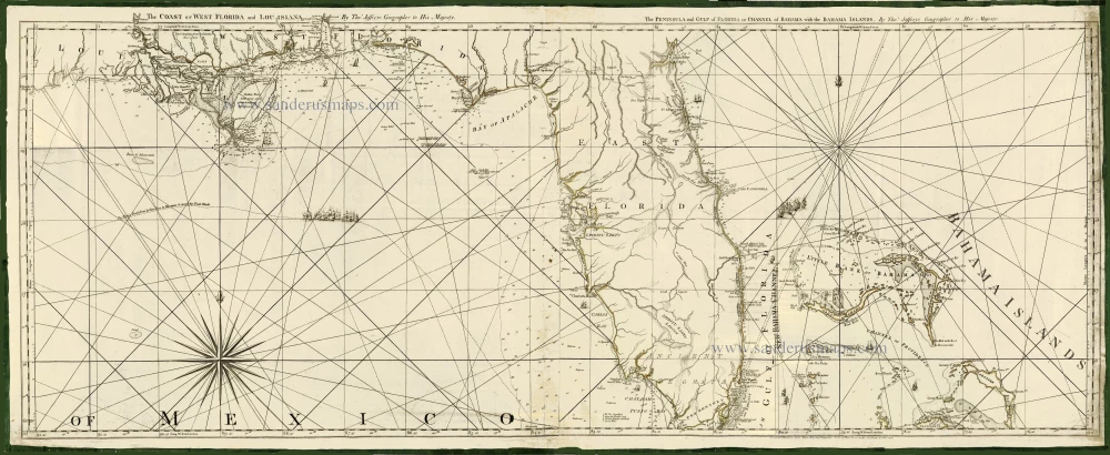
Florida & Louisiana by Thomas Jefferys. 1775
Thomas Jefferys (c. 1719-1771)
Thomas Jefferys was an outstanding English cartographer who was the leading map supplier of his day. He engraved and printed maps for government and other official bodies and produced a wide range of commercial maps and atlases. He made some of the finest maps of the time of North America and the West Indies.
He was appointed Geographer to the Prince of Wales and George II. However, in 1766, he became bankrupt and subsequently, the publication of his maps was managed by Robert Sayer, who in 1774 was joined in partnership by John Bennett and William Faden.
The Coast of West Florida and Louisiana. [in set with] The Peninsula and Gulf of Florida or Channel of Bahama with the Bahama Islands.
Item Number: 28203 Authenticity Guarantee
Category: Antique maps > America > North America
Old, antique map of Florida & Louisiana, by Jefferys Thomas.
Title: The Coast of West Florida and Louisiana. [in set with] The Peninsula and Gulf of Florida or Channel of Bahama with the Bahama Islands.
By Thos. Jefferys Geographer to His Majesty.
London. Printed for Robt. Saver, Map and Printseller, N° 53, in Fleet Street, as the Act directs. 20 Feby. 1775.
Engraver: Thomas Jefferys.
Date of the first edition: 1775.
Date of this map: 1775.
Date on map: 1775.
Copper engraving, printed on paper.
Size (not including margins): 495 x 1240mm (19.49 x 48.82 inches).
Verso: Blank.
Condition: Some professional repairs in the centre. Printed on two sheets of paper, joined, edges reinforced with green silk.
Condition Rating: B+.
References: Tooley (America), p. 65-66 #26a
From: Jefferys Thomas, The American Atlas. London, 1775.
Thomas Jefferys (c. 1719-1771)
Thomas Jefferys was an outstanding English cartographer who was the leading map supplier of his day. He engraved and printed maps for government and other official bodies and produced a wide range of commercial maps and atlases. He made some of the finest maps of the time of North America and the West Indies.
He was appointed Geographer to the Prince of Wales and George II. However, in 1766, he became bankrupt and subsequently, the publication of his maps was managed by Robert Sayer, who in 1774 was joined in partnership by John Bennett and William Faden.