
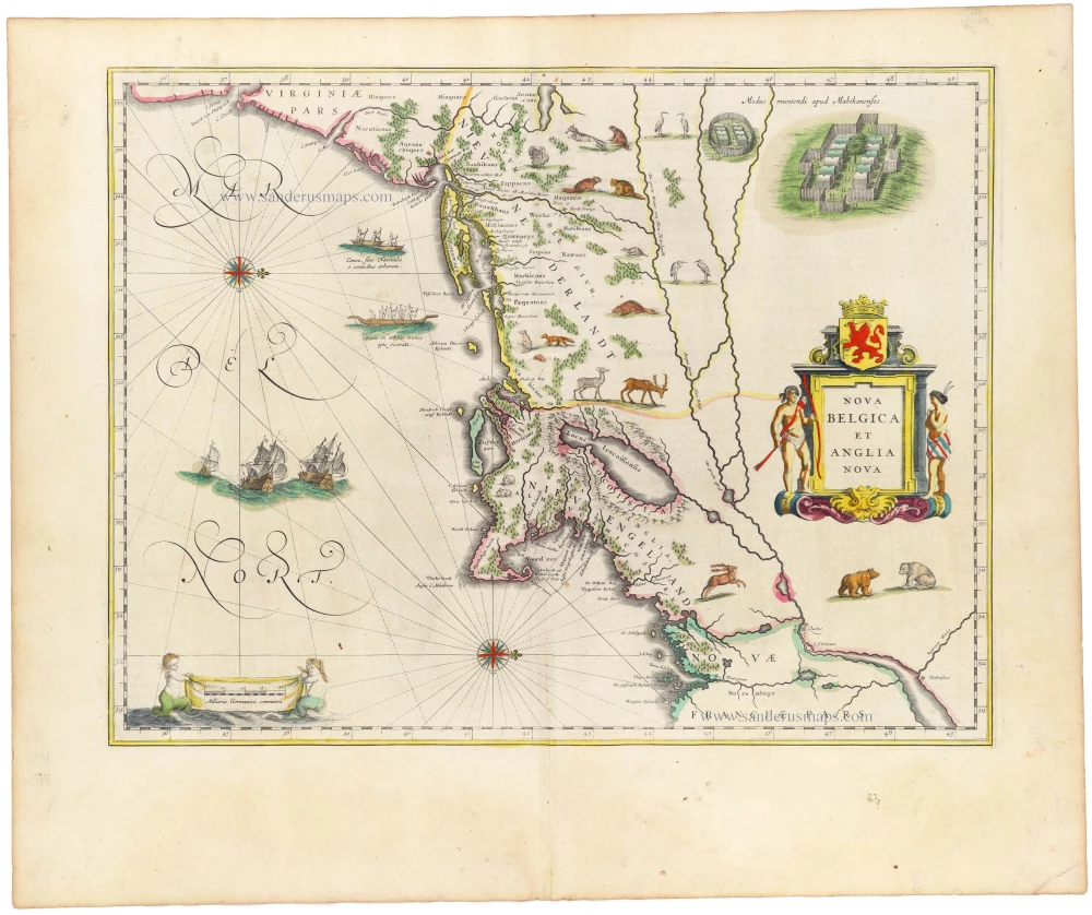
New England, Virginia, and New York by Nicolaes Visscher II. c. 1684


"Although the map itself is largely derived from that of Joannes Janssonius, 1651, it is of extreme importance for introducing a view of New Amsterdam in the lower right. This is probably the second published view of the city, the first being that of Joost Hartgers in 1651. It is possible that the previously unrecorded view affixed to the Jan Mathisz, c.1655, also pre-dates this. The authorship of the Visscher view is not known; some authorities claim that it was Augustine Herrman, although Stoke refutes this. The extensive study of the view in Stokes suggests a probable date for the original of between autumn, 1652, and summer, 1653. If correctly identified, the building far left was not constructed until after 30 April 1652. Therefore, it could not have been drawn after the 'wall' was built in 1653. This was an essential feature at the time in the town's security. Therefore, the printed map could have appeared as early as 1653 but no later than 1655.
In 1679 Visscher died leaving his son, Nicolaas Visscher II, to continue the business. Late in 1683, Thomas Holme's grid plan of Philadelphia was published. The following year a Dutch edition appeared by Jacob Claus. Visscher placed Philadelphia on the map in grid form, most probably following this. A privilege was added to the plate for the fourth state, which can be dated from as early as 1684 (Phillips 3449) to as late as 1696 (National Maritime Museum). States 2 to 4 are found in the various Visscher family atlases. The second state can be found inserted into examples of Blaeu and Janssonius atlases. Visscher II died in 1702, but the business flourished under his widow, Elizabeth, until 1726. Sometime either before this or following, the plate came into the hands of Petrus Schenk Jr., who promptly added his imprint." (Burden)
The Visscher Family
For nearly a century, the members of the Visscher family were essential art dealers and map publishers in Amsterdam.
Claes Jansz. Visscher, or N.J. Piscator (1587-1652)
Claes Jansz. Vischer bought a house in Amsterdam, 'de gulden Bors', on the crucial Kalverstraat and changed the name into "In de Visscher"; under this title, the shop was to flourish for many years.
He was famous for his engravings and etchings of Dutch landscapes and 'historical scenes', such as sieges, battles, etc. These 'historical scenes' were considered contemporary illustrated news items, especially e.g. that of 'the Eighty Years' War'.
For the publication of his first atlas, he bought copperplates of the atlas Germania Inferior by Pieter van den Keere (1623).
In 1649, he published an atlas entitled Tabularum Geographicarum Contractarum, containing the same maps as Langenes' Caert Thresoor, for which Visscher had only new title pages engraved.
Claes Jansz. Visscher died in 1652. His wife, Neeltjen Florisdr., had already died in 1640. They had seven children, four of whom were still alive at Claes Jansz.'s death. One was Nicolaes Visscher I, who was to continue his father's business.
Nicolaes Visscher I (1618-1679)
Nicolaes Visscher I partnered with his father, continued the business, and stayed on the Kalverstraat 'in de Visscher' till his death.
In about 1657, the first edition of his Atlas Contractus Orbis Terrarum appeared.
Between 1664 and 1677, several editions of his Atlas Contractus appeared without a printed index, for these atlases had no fixed contents but were composed according to the buyer's financial leaping pole.
In May 1664, Nicolaes Visscher was admitted as a member of the Booksellers' Guild of his town. In July 1677, he was granted a patent of the States of Holland and West-Friesland for printing and publishing maps and atlases for 15 years.
After this, he again published an Atlas Contractus with a printed index. At about the same time, he also brought out an Atlas Minor.
Nicolaes Visscher II (1649-1702)
Nicolaes Visscher II inherited the 'shop' from his father. To obtain a new privilege, he applied to the States of Holland and West-Friesland in 1682 for a patent for printing and publishing maps. This patent was granted to him the same year. He moved the firm to the Dam, but it kept the same signboard: "In de Visscher".
Around 1683, he published his first Atlas Minor with a printed index of 91 maps. In 1684, an atlas Germania Inferior appeared. Till 1697, he published another number of atlases. He used his grandfather's (Claes Jansz.) maps less often now and relied more and more on his own.
The wars waged at this time initiated the compilation of maps of the countries where the armies operated. Many war maps were included in the various editions of his Atlas Minor.
After Nicolaes's death, his wife, Elizabeth Verseyl, published all the war maps as an atlas under the title De Stoel des Oorlogs in de Wereld (The seat of war in the world).
The widow of Nicolaes Visscher II (?-1726)
His widow continued the business energetically, and by her hand, under the name of her deceased husband, numerous atlases appeared, e.g., several editions of the Atlas Minor, an Atlas Maior and De Stoel des Oorlogs. The shop enjoyed a high reputation due to the assortment's incredible variety. Not only 'Visscher' maps but also maps of other publishers were obtainable. With the death of Elizabeth Verseyl in 1726, the last descendant died of a great map- and atlas-publishing firm in Amsterdam.
Novi Belgii novaeque Angliae nec non partis Virginiae Tabula.
Currently not available
Item Number: 29408 Authenticity Guarantee
Category: Antique maps > America > North America
Old, antique map of the northeast of the U.S., by Nicolas Visscher II.
With an inset view of New York ("Nieuw Amsterdam").
Title: Novi Belgii novaeque Angliae nec non partis Virginiae Tabula.
multis in locis emendata per Nicolaum Visscher.
cum Privil: Ordin: General: Belgii Foederati;
Fourth state: With privilege.
Date of the first edition: c. 1655.
Date of this map: c. 1684.
Copper engraving, printed on paper.
Map size: 465 x 555mm (18.31 x 21.85 inches).
Sheet size: 525 x 615mm (20.67 x 24.21 inches).
Verso: Blank.
Condition: Original coloured, excellent.
Condition Rating: A+.
From: Atlas Minor Sive totius Orbis Terrarum contracta delineat(a) ex conatibus Nic(olaus) Visscher ... Amsterdam, N. Visscher II, 1683-1702.
"Although the map itself is largely derived from that of Joannes Janssonius, 1651, it is of extreme importance for introducing a view of New Amsterdam in the lower right. This is probably the second published view of the city, the first being that of Joost Hartgers in 1651. It is possible that the previously unrecorded view affixed to the Jan Mathisz, c.1655, also pre-dates this. The authorship of the Visscher view is not known; some authorities claim that it was Augustine Herrman, although Stoke refutes this. The extensive study of the view in Stokes suggests a probable date for the original of between autumn, 1652, and summer, 1653. If correctly identified, the building far left was not constructed until after 30 April 1652. Therefore, it could not have been drawn after the 'wall' was built in 1653. This was an essential feature at the time in the town's security. Therefore, the printed map could have appeared as early as 1653 but no later than 1655.
In 1679 Visscher died leaving his son, Nicolaas Visscher II, to continue the business. Late in 1683, Thomas Holme's grid plan of Philadelphia was published. The following year a Dutch edition appeared by Jacob Claus. Visscher placed Philadelphia on the map in grid form, most probably following this. A privilege was added to the plate for the fourth state, which can be dated from as early as 1684 (Phillips 3449) to as late as 1696 (National Maritime Museum). States 2 to 4 are found in the various Visscher family atlases. The second state can be found inserted into examples of Blaeu and Janssonius atlases. Visscher II died in 1702, but the business flourished under his widow, Elizabeth, until 1726. Sometime either before this or following, the plate came into the hands of Petrus Schenk Jr., who promptly added his imprint." (Burden)
The Visscher Family
For nearly a century, the members of the Visscher family were essential art dealers and map publishers in Amsterdam.
Claes Jansz. Visscher, or N.J. Piscator (1587-1652)
Claes Jansz. Vischer bought a house in Amsterdam, 'de gulden Bors', on the crucial Kalverstraat and changed the name into "In de Visscher"; under this title, the shop was to flourish for many years.
He was famous for his engravings and etchings of Dutch landscapes and 'historical scenes', such as sieges, battles, etc. These 'historical scenes' were considered contemporary illustrated news items, especially e.g. that of 'the Eighty Years' War'.
For the publication of his first atlas, he bought copperplates of the atlas Germania Inferior by Pieter van den Keere (1623).
In 1649, he published an atlas entitled Tabularum Geographicarum Contractarum, containing the same maps as Langenes' Caert Thresoor, for which Visscher had only new title pages engraved.
Claes Jansz. Visscher died in 1652. His wife, Neeltjen Florisdr., had already died in 1640. They had seven children, four of whom were still alive at Claes Jansz.'s death. One was Nicolaes Visscher I, who was to continue his father's business.
Nicolaes Visscher I (1618-1679)
Nicolaes Visscher I partnered with his father, continued the business, and stayed on the Kalverstraat 'in de Visscher' till his death.
In about 1657, the first edition of his Atlas Contractus Orbis Terrarum appeared.
Between 1664 and 1677, several editions of his Atlas Contractus appeared without a printed index, for these atlases had no fixed contents but were composed according to the buyer's financial leaping pole.
In May 1664, Nicolaes Visscher was admitted as a member of the Booksellers' Guild of his town. In July 1677, he was granted a patent of the States of Holland and West-Friesland for printing and publishing maps and atlases for 15 years.
After this, he again published an Atlas Contractus with a printed index. At about the same time, he also brought out an Atlas Minor.
Nicolaes Visscher II (1649-1702)
Nicolaes Visscher II inherited the 'shop' from his father. To obtain a new privilege, he applied to the States of Holland and West-Friesland in 1682 for a patent for printing and publishing maps. This patent was granted to him the same year. He moved the firm to the Dam, but it kept the same signboard: "In de Visscher".
Around 1683, he published his first Atlas Minor with a printed index of 91 maps. In 1684, an atlas Germania Inferior appeared. Till 1697, he published another number of atlases. He used his grandfather's (Claes Jansz.) maps less often now and relied more and more on his own.
The wars waged at this time initiated the compilation of maps of the countries where the armies operated. Many war maps were included in the various editions of his Atlas Minor.
After Nicolaes's death, his wife, Elizabeth Verseyl, published all the war maps as an atlas under the title De Stoel des Oorlogs in de Wereld (The seat of war in the world).
The widow of Nicolaes Visscher II (?-1726)
His widow continued the business energetically, and by her hand, under the name of her deceased husband, numerous atlases appeared, e.g., several editions of the Atlas Minor, an Atlas Maior and De Stoel des Oorlogs. The shop enjoyed a high reputation due to the assortment's incredible variety. Not only 'Visscher' maps but also maps of other publishers were obtainable. With the death of Elizabeth Verseyl in 1726, the last descendant died of a great map- and atlas-publishing firm in Amsterdam.
Related items

Very important map with a view of New York
Novi Belgii novaeque Angliae nec non partis Virginiae Tabula. 1656-77
New England by Nicolaes Visscher I.
[Item number: 28549]

Representation du Feu terrible a Nouvelle York ca. 1776-1780
Perspective view of the fire in New York.
[Item number: 28993]
Nova Belgica et Anglia Nova. 1645
New England by Willem Blaeu
[Item number: 33023]
new