Florida by Johannes de Laet 1630
Considerable effort went into making the text and maps of this work the most accurate available at the time. It is arguably the finest description of the Americas published in the seventeenth century. The exhaustive research involved de Laet reading all the published and manuscript material he could find. He had much to call on for the cartographic work, being a director of the recently formed Dutch West India Company in charge of all Dutch interests in America and Africa. He, therefore, had access to the latest geographic knowledge. He also drew upon the fine talents of Hessel Gerritsz, the official cartographer to the Dutch East India Company since 1617. This was a post he attained before Willem Blaeu, under whom he was apprenticed and who was his senior by ten years.
The maps were some of the first to depart from the heavier style of the Mercator and Ortelius period. This more open engraving style was one that both Blaeu and Janssonius would develop in their atlases. The book's first edition in 1625 contained ten maps which concentrated on South America. Since then, the Dutch had taken considerable interest in New Amsterdam (New York), and the work was expanded by some 100 pages and four newly engraved maps.
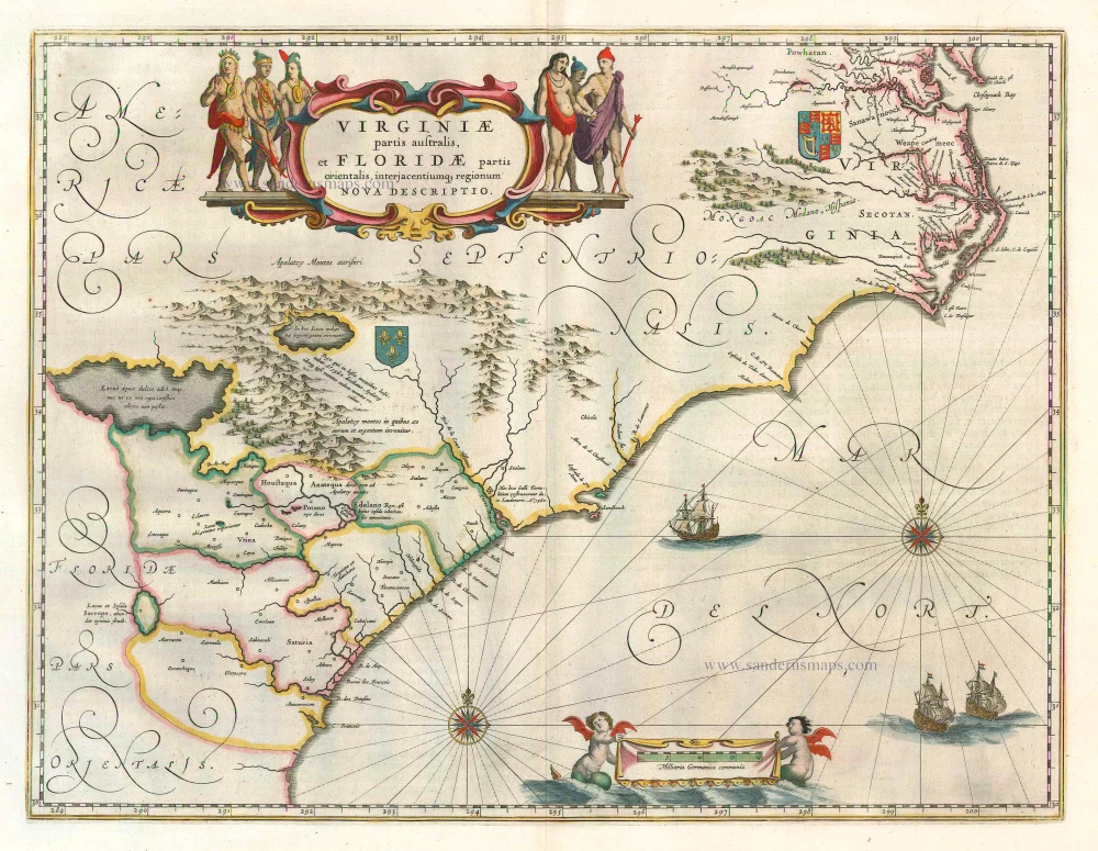
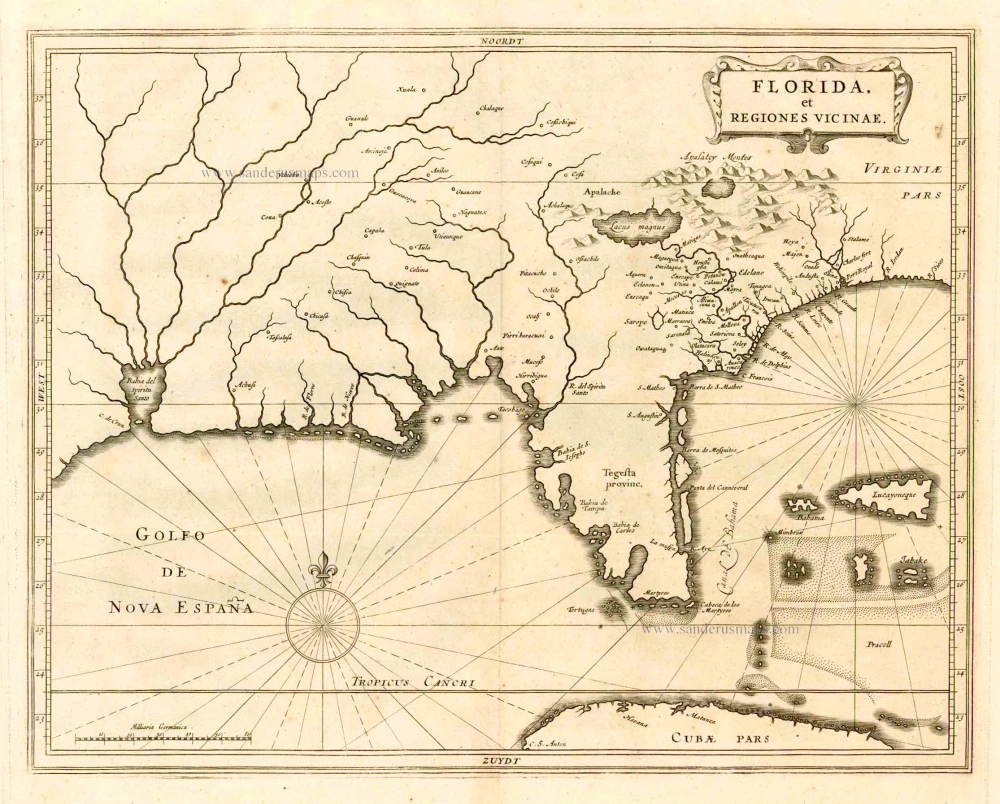
This is one of three maps that relate to the east coast of North America in de Laet's work. This is arguably the finest description of the Americas published in the seventeenth century. Even though he drew on many sources for his information, no fresh material on the area had been forthcoming for decades. Hessel Gerritsz, the author and probable engraver of the map, drew, therefore, on the interpretation by Claesz, c.1602, of the Jacques le Moyne cartography of Florida. Originally thought to be taken from Jodocus Hondius' map of Virginia and Florida, 1606, this study demonstrates otherwise. One notable area of alteration is the placing of C. François further east into the Atlantic Ocean. Florida, as we know it today, is here called Tegesta provinc. This name, applied here for the first time, is that of a tribe of Indians living on the southwest coast. "Florida" was at that time applied to a far larger region. It came to be used solely for the peninsula as Spanish Florida was squeezed south by the expansion of the English colonies.
For the rest of the map, he drew upon the nomenclature of the Ortelius-Chaves map of 1584. The river delta system, however, is still confusing. The Bahia del Spiritu Santo is often thought to refer to the mouth of the Mississippi River. Studies have questioned the assumption of this attribution. The map's influence was quite considerable. Blaeu, Janssonius and Sanson all followed it. (Burden)
Hessel Gerritsz. (1580/81 – 1632)
Hessel Gerritsz. was one of the seventeenth century's most influential and innovative map makers. He was born in Assum in North Holland and attended Alkmaar school. He must have known Willem Jansz. (= Willem Blaeu) who stayed in Alkmaar for several years. Later, he moved to Amsterdam for his further education.
After the closing of the Scheldt River, Amsterdam’s competitor was cut off so Amsterdam could take over the world trade centre's function. Flourishing Amsterdam offered plenty of work and was an excellent attraction for artisans from the Southern Netherlands. The two dominating publishers in the cartographical field were Cornelis Claesz. and Jodocus Hondius, both from the Southern Netherlands. Hessel Gerritsz. was trained in the graphic trade by David Vingboons, a painter and artist from the Southern Netherlands.
After his apprenticeship with David Vingboons, Hessel Gerritsz. continued his schooling in the publishing house of Willem Jansz. (Blaeu). There, he could perfect his etching style, was given the mathematical skills that would be useful to him later, and learned the trade of mapmaking. With the engraver Josua van den Ende, he was responsible for engraving the superb wall map of the Seventeen Provinces (1608). Van den Ende engraved the map image while Hessel Gerritsz. took care of the decorative borders and the decorations on the main map.
During his activities for Willem Jansz. Hessel Gerritsz. not only perfected his etching and engraving style but also received the geographical and mathematical education that would stand him in good stead in later years. He could not wish for a better cartographical school. Blaeu’s workshop was a repository where geographical information from all parts of the world came together.
Hessel Gerritsz. married in 1607 to Geertje Gijsbertdr. One of his children, Gerrit, born in 1609, was to follow in his father’s footsteps. Shortly after his marriage, he established himself as an independent engraver, mapmaker and printer.
Hessel Gerritsz. regularly worked with Claes Jansz. Visscher, as well. They cooperated for a long time.
His artistic talent comes to the fore in his map of the Leo Belgicus, depicting the Seventeen Provinces in the shape of a lion. This was seen as a symbol of the courage and persistence of the Dutch provinces in their resistance against Spanish tyranny.
In 1612-13, Hessel Gerritsz. was intensively busy with publications about Russia. In 1612, he published the influential booklet Beschryvinghe vander Samoyeden Landt. The two chapters about Siberia were provided by Isaac Massa, who had lived in Moscow for nine years. With the aid of original Russian material, Gerrritsz. produced a series of three maps in folio format: a map of Russia and Moscow and the Kremlin town plans. He also made an essential new wall map of Lithuania and engraved it on four plates for Willem Blaeu. In the meantime, he also made a wall map and a folio map of Spain.
Next to these works undertaken on his initiative, Hessel Gerritsz. also accepted engraving and publishing tasks for third parties.
In 1617, Hessel Gerritsz. published a large wall map of Italy in six sheets. He gave his wall map an extra cachet by extending the map image with town views and costumed figures. The map was copied shortly after publication by Willem Blaeu. To protect himself against such plagiarism in the future, he requested a patent from the States-General. In January 1618, they granted him a general license in which, amongst other things, it was forbidden in any way to reproduce, copy or distribute his maps, both written or printed.
Hessel Gerritsz. was so highly regarded in 1617 that he received such an extraordinary privilege. He was appointed as a geography instructor for the Councillors of the Admiralty at Amsterdam and as a mapmaker for the Chamber Amsterdam of the VOC. With both appointments, his old employer, Willem Blaeu, was passed over. In his function as VOC's mapmaker, he improved and expanded the charts for navigation to and from the Indies. The chart maker, of course, did not draw the charts needed for the VOC ships himself. He manufactured specific prototypes, the so-called leggers (master charts), which served as models for copying work by his assistants in his house.
At the beginning of September 1632, Hessel Gerritsz. died at the age of 52. He must be considered one of the most comprehensive map makers of his time. “He was multi-disciplined in his working method, integrating graphical technique and artistic expression in his scientific approach. Because of his mathematical talent, he could solve nautical problems and make proposals about them. His exceptional network – the interviews with pilots from diverse companies and his correspondence with persons at home and abroad – supplied him with a huge amount of geographical and nautical information that he used most efficiently. His good contacts with the families of the great merchants, ship owners, and the influential regents' representatives opened doors for him. He was, without doubt, the most informed person in geographical matters in Amsterdam of his time.” (Schilder)
Florida, et Regiones Vicinae.
Item Number: 25384 Authenticity Guarantee
Category: Antique maps > America > North America
Old, antique map of Florida, by J. de Laet
Cartographer: Hessel Gerritsz
Date of the first edition: 1630
Date of this map: 1630
Copper engraving
Size (not including margins): 28.5 x 36cm (11 x 14 inches)
Verso: Blank
Condition: Excellent.
Condition Rating: A+
References: Burden 232; Cumming, 34; Schilder 9, XIII.2.4 Pl. 13.58
From: Beschrijvinghe van West-Indien. Leiden, 1630.
Considerable effort went into making the text and maps of this work the most accurate available at the time. It is arguably the finest description of the Americas published in the seventeenth century. The exhaustive research involved de Laet reading all the published and manuscript material he could find. He had much to call on for the cartographic work, being a director of the recently formed Dutch West India Company in charge of all Dutch interests in America and Africa. He, therefore, had access to the latest geographic knowledge. He also drew upon the fine talents of Hessel Gerritsz, the official cartographer to the Dutch East India Company since 1617. This was a post he attained before Willem Blaeu, under whom he was apprenticed and who was his senior by ten years.
The maps were some of the first to depart from the heavier style of the Mercator and Ortelius period. This more open engraving style was one that both Blaeu and Janssonius would develop in their atlases. The book's first edition in 1625 contained ten maps which concentrated on South America. Since then, the Dutch had taken considerable interest in New Amsterdam (New York), and the work was expanded by some 100 pages and four newly engraved maps.
This is one of three maps that relate to the east coast of North America in de Laet's work. This is arguably the finest description of the Americas published in the seventeenth century. Even though he drew on many sources for his information, no fresh material on the area had been forthcoming for decades. Hessel Gerritsz, the author and probable engraver of the map, drew, therefore, on the interpretation by Claesz, c.1602, of the Jacques le Moyne cartography of Florida. Originally thought to be taken from Jodocus Hondius' map of Virginia and Florida, 1606, this study demonstrates otherwise. One notable area of alteration is the placing of C. François further east into the Atlantic Ocean. Florida, as we know it today, is here called Tegesta provinc. This name, applied here for the first time, is that of a tribe of Indians living on the southwest coast. "Florida" was at that time applied to a far larger region. It came to be used solely for the peninsula as Spanish Florida was squeezed south by the expansion of the English colonies.
For the rest of the map, he drew upon the nomenclature of the Ortelius-Chaves map of 1584. The river delta system, however, is still confusing. The Bahia del Spiritu Santo is often thought to refer to the mouth of the Mississippi River. Studies have questioned the assumption of this attribution. The map's influence was quite considerable. Blaeu, Janssonius and Sanson all followed it. (Burden)
Hessel Gerritsz. (1580/81 – 1632)
Hessel Gerritsz. was one of the seventeenth century's most influential and innovative map makers. He was born in Assum in North Holland and attended Alkmaar school. He must have known Willem Jansz. (= Willem Blaeu) who stayed in Alkmaar for several years. Later, he moved to Amsterdam for his further education.
After the closing of the Scheldt River, Amsterdam’s competitor was cut off so Amsterdam could take over the world trade centre's function. Flourishing Amsterdam offered plenty of work and was an excellent attraction for artisans from the Southern Netherlands. The two dominating publishers in the cartographical field were Cornelis Claesz. and Jodocus Hondius, both from the Southern Netherlands. Hessel Gerritsz. was trained in the graphic trade by David Vingboons, a painter and artist from the Southern Netherlands.
After his apprenticeship with David Vingboons, Hessel Gerritsz. continued his schooling in the publishing house of Willem Jansz. (Blaeu). There, he could perfect his etching style, was given the mathematical skills that would be useful to him later, and learned the trade of mapmaking. With the engraver Josua van den Ende, he was responsible for engraving the superb wall map of the Seventeen Provinces (1608). Van den Ende engraved the map image while Hessel Gerritsz. took care of the decorative borders and the decorations on the main map.
During his activities for Willem Jansz. Hessel Gerritsz. not only perfected his etching and engraving style but also received the geographical and mathematical education that would stand him in good stead in later years. He could not wish for a better cartographical school. Blaeu’s workshop was a repository where geographical information from all parts of the world came together.
Hessel Gerritsz. married in 1607 to Geertje Gijsbertdr. One of his children, Gerrit, born in 1609, was to follow in his father’s footsteps. Shortly after his marriage, he established himself as an independent engraver, mapmaker and printer.
Hessel Gerritsz. regularly worked with Claes Jansz. Visscher, as well. They cooperated for a long time.
His artistic talent comes to the fore in his map of the Leo Belgicus, depicting the Seventeen Provinces in the shape of a lion. This was seen as a symbol of the courage and persistence of the Dutch provinces in their resistance against Spanish tyranny.
In 1612-13, Hessel Gerritsz. was intensively busy with publications about Russia. In 1612, he published the influential booklet Beschryvinghe vander Samoyeden Landt. The two chapters about Siberia were provided by Isaac Massa, who had lived in Moscow for nine years. With the aid of original Russian material, Gerrritsz. produced a series of three maps in folio format: a map of Russia and Moscow and the Kremlin town plans. He also made an essential new wall map of Lithuania and engraved it on four plates for Willem Blaeu. In the meantime, he also made a wall map and a folio map of Spain.
Next to these works undertaken on his initiative, Hessel Gerritsz. also accepted engraving and publishing tasks for third parties.
In 1617, Hessel Gerritsz. published a large wall map of Italy in six sheets. He gave his wall map an extra cachet by extending the map image with town views and costumed figures. The map was copied shortly after publication by Willem Blaeu. To protect himself against such plagiarism in the future, he requested a patent from the States-General. In January 1618, they granted him a general license in which, amongst other things, it was forbidden in any way to reproduce, copy or distribute his maps, both written or printed.
Hessel Gerritsz. was so highly regarded in 1617 that he received such an extraordinary privilege. He was appointed as a geography instructor for the Councillors of the Admiralty at Amsterdam and as a mapmaker for the Chamber Amsterdam of the VOC. With both appointments, his old employer, Willem Blaeu, was passed over. In his function as VOC's mapmaker, he improved and expanded the charts for navigation to and from the Indies. The chart maker, of course, did not draw the charts needed for the VOC ships himself. He manufactured specific prototypes, the so-called leggers (master charts), which served as models for copying work by his assistants in his house.
At the beginning of September 1632, Hessel Gerritsz. died at the age of 52. He must be considered one of the most comprehensive map makers of his time. “He was multi-disciplined in his working method, integrating graphical technique and artistic expression in his scientific approach. Because of his mathematical talent, he could solve nautical problems and make proposals about them. His exceptional network – the interviews with pilots from diverse companies and his correspondence with persons at home and abroad – supplied him with a huge amount of geographical and nautical information that he used most efficiently. His good contacts with the families of the great merchants, ship owners, and the influential regents' representatives opened doors for him. He was, without doubt, the most informed person in geographical matters in Amsterdam of his time.” (Schilder)