Old antique map of New England by J.B. Homann c. 1720
The Homann Family
Johann Baptist Homann (1664-1724) was born in Oberkammlach in Southern Germany. Around 1693 Homann moved to Vienna, where he lived and studied printing and copper plate engraving until 1695. In 1702 he founded a map publishing company in Nuremberg, which is recognized as one of the most important German map publishers of the eighteenth century. In the next five years, Homann produced hundreds of maps and developed a distinctive style characterized by heavy detailed engraving, elaborate allegorical cartouche work, and vivid hand colour. He published his first atlas in 1707. Homann's company successfully competed with leading European mapmakers. By 1715 Homann's rising star caught the attention of the Holy Roman Emperor Charles the VI, who appointed him Imperial Cartographer. In the same year, he was also appointed a member of the Royal Academy of Sciences in Berlin. Homann's prestigious title came with several significant advantages, including access to the most up to date cartographic information as well as the "Privilege". In 1716 Homann published his masterpiece Grosser Atlas über die ganze Welt (Grand Atlas of all the World).
After Johann Baptist Homann's death in 1724, Johan Christoph Homann (1703-1730) and other heirs continued the company under the name Homann's Erben (Homann's Heirs) until 1852.
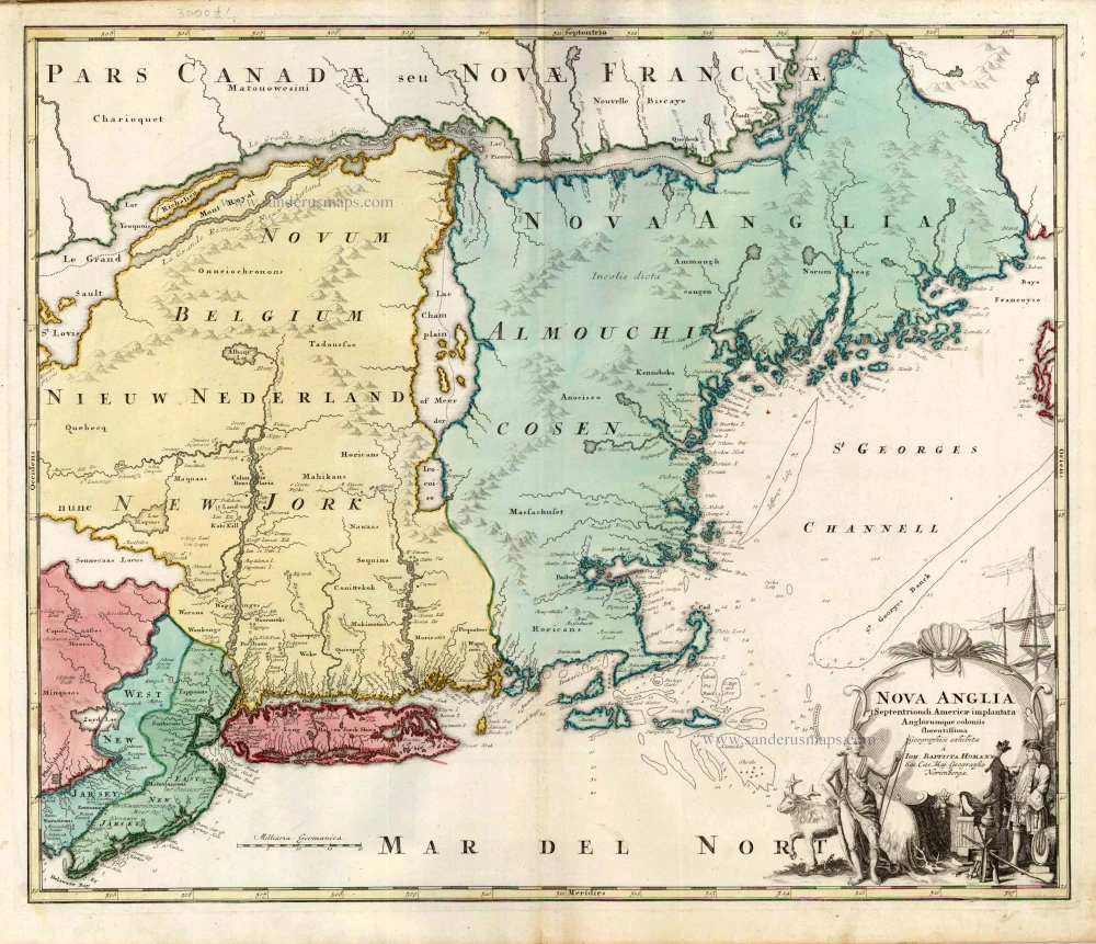
Nova Anglia Septentrionali Americae Implantata Anglorumque Coloniis Florentissima Geographice Exhibita ...
Item Number: 14149 Authenticity Guarantee
Category: Antique maps > America > North America
Old, antique map of New England by Homann J.B.
Published in Nuremberg.
Copper engraving
Size: 49 x 58cm (19.1 x 22.6 inches)
Verso: Blank
Condition: Contemporary old coloured, excellent.
Condition Rating: A+
References: Portinaro - Knirsch, CXVI;.
The Homann Family
Johann Baptist Homann (1664-1724) was born in Oberkammlach in Southern Germany. Around 1693 Homann moved to Vienna, where he lived and studied printing and copper plate engraving until 1695. In 1702 he founded a map publishing company in Nuremberg, which is recognized as one of the most important German map publishers of the eighteenth century. In the next five years, Homann produced hundreds of maps and developed a distinctive style characterized by heavy detailed engraving, elaborate allegorical cartouche work, and vivid hand colour. He published his first atlas in 1707. Homann's company successfully competed with leading European mapmakers. By 1715 Homann's rising star caught the attention of the Holy Roman Emperor Charles the VI, who appointed him Imperial Cartographer. In the same year, he was also appointed a member of the Royal Academy of Sciences in Berlin. Homann's prestigious title came with several significant advantages, including access to the most up to date cartographic information as well as the "Privilege". In 1716 Homann published his masterpiece Grosser Atlas über die ganze Welt (Grand Atlas of all the World).
After Johann Baptist Homann's death in 1724, Johan Christoph Homann (1703-1730) and other heirs continued the company under the name Homann's Erben (Homann's Heirs) until 1852.