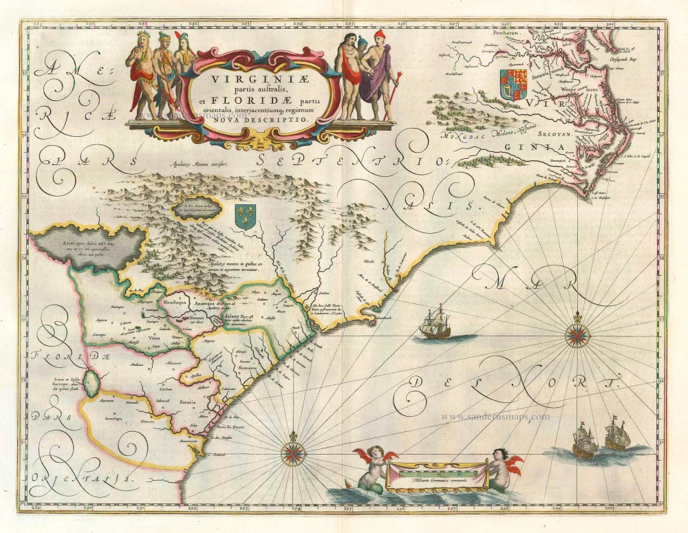
Old antique map of New England & Virginia by J. de Laet. 1630

Considerable effort went into making the text and maps of this work the most accurate available at the time. It is arguably the finest description of the Americas published in the seventeenth century. The exhaustive research involved de Laet reading all the published and manuscript material he could find. He had much to call on for the cartographic work, being a director of the recently formed Dutch West India Company in charge of all Dutch interests in America and Africa. He, therefore, had access to the latest geographic knowledge. He also drew upon the fine talents of Hessel Gerritsz, the official cartographer to the Dutch East India Company since 1617. This was a post he attained before Willem Blaeu, under whom he was apprenticed and who was his senior by ten years.
The maps were some of the first to depart from the heavier style of the Mercator and Ortelius period. This more open style of engraving was one that both Blaeu and Janssonius would develop in their atlases. The book's first edition, 1625, contained ten maps concentrating on South America. Since then, the Dutch have taken considerable interest in New Amsterdam (New York), and the work has expanded by 100 pages and four newly engraved maps.
This is a map of extreme importance, being the first printed one to use the names Manhattes (Manhattan), and N. Amsterdam, or New York, founded in 1626. It is also the earliest to use the Dutch names of Noordt Rivier and Zuyd Rivier for the Hudson and Delaware Rivers, respectively, and the Indian Massachusets for the new English colony. It influenced many later maps in their depiction of the coast.
Hessel Gerritz, the author and probable engraver of the map, had been the official cartographer of the Dutch East India Company since 1617. He would have seen all the documentation and charts from the Dutch voyages into the area of the Hudson River. His depiction of the coastal region between Chesapeake Bay and Cape Cod is by far the finest yet seen. This is even though he still illustrates the Delaware River flowing from a large lake. This is descended from the so-called figurative map of Cornelis Hendricks, 1616. The map exhibits signs of being familiar with the other crucial derivative map of the period, that of Adriaen Block, 1614. This is the first occurrence on a map of NOVUM BELGIUM, or New Netherlands, in the title. The reason for it being referred to here as Belgium is that the majority of the backing of the Dutch West India Company was by Walloon Protestants from that region. (Burden)
Nova Anglia, Novum Belgium et Virginia.
Item Number: 25385 Authenticity Guarantee
Category: Antique maps > America > North America
Old, antique map of New England - Virginia by J. de Laet
With an inset of Bermuda.
Cartographer: Hessel Gerritsz
Date of the first edition: 1630
Date of this map: 1630
Copper engraving
Size (not including margins): 28.5 x 35.5cm (11 x 13.9 inches)
Verso: Blank
Condition: Two small rust stains, else excellent.
Condition Rating: A
References: Burden, 231; Cumming, 35.
From: Beschrijvinghe van West-Indien. Leiden, 1630.
Considerable effort went into making the text and maps of this work the most accurate available at the time. It is arguably the finest description of the Americas published in the seventeenth century. The exhaustive research involved de Laet reading all the published and manuscript material he could find. He had much to call on for the cartographic work, being a director of the recently formed Dutch West India Company in charge of all Dutch interests in America and Africa. He, therefore, had access to the latest geographic knowledge. He also drew upon the fine talents of Hessel Gerritsz, the official cartographer to the Dutch East India Company since 1617. This was a post he attained before Willem Blaeu, under whom he was apprenticed and who was his senior by ten years.
The maps were some of the first to depart from the heavier style of the Mercator and Ortelius period. This more open style of engraving was one that both Blaeu and Janssonius would develop in their atlases. The book's first edition, 1625, contained ten maps concentrating on South America. Since then, the Dutch have taken considerable interest in New Amsterdam (New York), and the work has expanded by 100 pages and four newly engraved maps.
This is a map of extreme importance, being the first printed one to use the names Manhattes (Manhattan), and N. Amsterdam, or New York, founded in 1626. It is also the earliest to use the Dutch names of Noordt Rivier and Zuyd Rivier for the Hudson and Delaware Rivers, respectively, and the Indian Massachusets for the new English colony. It influenced many later maps in their depiction of the coast.
Hessel Gerritz, the author and probable engraver of the map, had been the official cartographer of the Dutch East India Company since 1617. He would have seen all the documentation and charts from the Dutch voyages into the area of the Hudson River. His depiction of the coastal region between Chesapeake Bay and Cape Cod is by far the finest yet seen. This is even though he still illustrates the Delaware River flowing from a large lake. This is descended from the so-called figurative map of Cornelis Hendricks, 1616. The map exhibits signs of being familiar with the other crucial derivative map of the period, that of Adriaen Block, 1614. This is the first occurrence on a map of NOVUM BELGIUM, or New Netherlands, in the title. The reason for it being referred to here as Belgium is that the majority of the backing of the Dutch West India Company was by Walloon Protestants from that region. (Burden)