
North Pole by Coronelli V.M. 1691
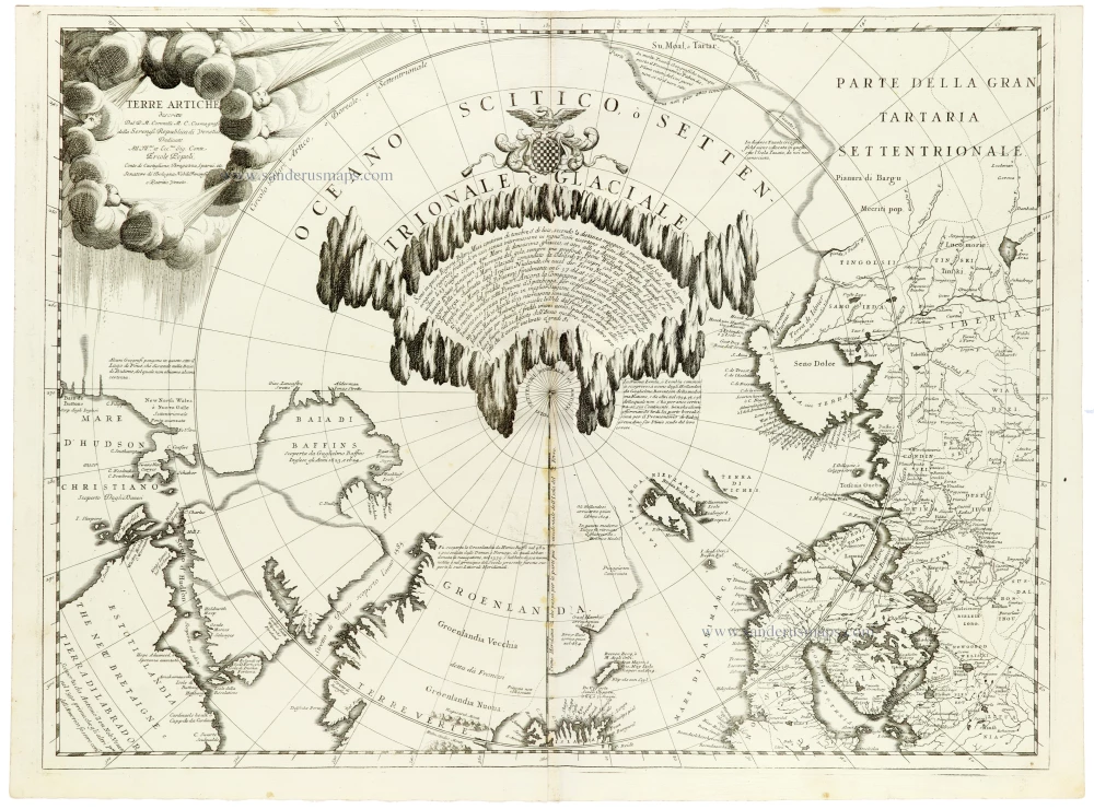
A magnificent and highly decorative map of the Arctic regions by Vincenzo Maria Coronelli, one of the most celebrated Italian cartographers of the late seventeenth century. Published in Venice in 1691, this remarkable polar map combines contemporary geographical discoveries with traditional cartographic theories and an exceptionally imaginative representation of the unexplored North Pole.
The map uses a north polar projection, with the North Pole at its centre and northern Europe, Asia, Greenland, and North America arranged around it. It extends southwards to include Hudson Bay, Greenland, Iceland, Scandinavia, northern Russia, Siberia, and the northern coast of North America. The geographical information reflects the discoveries of European navigators and explorers, particularly those seeking the elusive Northeast and Northwest Passages.
The most striking feature is Coronelli's extraordinary representation of the polar ice. The central Arctic Ocean is dominated by a spectacular circular arrangement of enormous, jagged ice formations, labelled Territoriale Glaciale. These towering masses of ice surround the North Pole, creating an almost theatrical landscape. Within this imaginary frozen territory, extensive explanatory text discusses the geography and conditions of the polar regions. This remarkable depiction illustrates the Arctic's limited geographical knowledge at the end of the seventeenth century and the imaginative solutions cartographers used to represent unexplored territories.
The map is particularly interesting for its treatment of the northern coast of America and the Canadian Arctic. Hudson Bay is prominently shown, together with Baffin Bay, Davis Strait, and the surrounding islands and coastlines. Coronelli incorporates geographical information derived from the voyages of Henry Hudson, William Baffin, and other early explorers, while retaining conjectural coastlines and geographical features in regions that remained largely unknown.
Greenland occupies a prominent position in the lower centre of the map, where Coronelli distinguishes between Groenlandia Vecchia and Groenlandia Nuova, reflecting the island's geographical terminology and historical traditions. To the east, the Arctic archipelagos of Spitsbergen and Novaya Zemlya are represented, together with the northern coast of Scandinavia and Russia. Farther east, the extensive Siberian coastline illustrates the still incomplete European knowledge of northern Asia.
Numerous geographical annotations and explanatory texts are distributed throughout the map, referring to voyages, discoveries, coastal features, and the uncertain geography of the northern seas. These notes make the map an important document for the history of Arctic exploration and the development of European geographical knowledge.
The decorative engraving is exceptionally impressive. In the upper left corner, the title Terre Artiche appears within an elaborate cartouche formed by billowing clouds, from which dramatic rays extend across the polar sky. Above the central ice formations is a finely engraved coat of arms, surmounted by an eagle and surrounded by elaborate Baroque scrollwork. The densely engraved ice cliffs, elegant geographical lettering, and carefully constructed polar projection contribute to the map's distinctive visual character.
An exceptional example of seventeenth-century polar cartography, distinguished by its spectacular depiction of the Arctic ice, its wealth of information on early northern exploration, and its magnificent Venetian Baroque engraving.
Vincenzo Coronelli (1650-1718)
Vincenzo Coronelli was born in Venice on 16 August 1650 and primarily brought up in Ravenna. He returned to Venice in 1665 and joined the convent of the Minor Conventuals. Five years later, he was sent to Rome to study, and by 1673, he was already a doctor of theology.
Having achieved fame by constructing two globes for the Duke of Parma, he was invited to Paris for three years in 1681 and made two enormous examples for Louis XIV. On his return to Venice, he assiduously collected cartographic material and founded the Academy of the Argonauts. In 1685, he was appointed Cosmographer to the Republic of Venice and authorised to publish a large atlas. He became a geography lecturer at the University of Venice and brought out an Atlante Veneto the following year.
In 1696, he visited Germany, Holland and southern England. During intervals in compiling his vast encyclopaedia, he continued with cartographic projects up to 1709. He died in his native Venice on 9 December 1718.
Coronelli became famous for his globes. In addition, he was a renowned encyclopaedist, mapmaker and geographer. Most of his maps and other material are gathered in his Atlante Veneto (13 vols, 1690-1705). The first volume, subtitled Descrizione generale istorica geografica, was his masterpiece, planned as an extension of Blaeu’s atlas.
Other volumes of the atlas which contain maps are Isolario, two parts (1696-8), with detailed maps and plans, mostly of islands; Corso geografico, two parts based on the edition 1694-7; Libro de’ globi (1697); and Lo Specchio del Mare, a reprint of Levanto's Lo Specchio del Mare Mediterraneo of 1664.
The other vital aspects of his mapping are those arising from the Venetian conquest and his travels. His most extensive military compilation was the Teatro della Guerra, in more than 30 volumes.
Terre Artiche.
Item Number: 33310 new Authenticity Guarantee
Category: Antique maps > America > South America
North Pole by Coronelli V.M.
Title: Terre Artiche.
Dal P.M. Coronelli M.C. Cosmografo della Sereniß. Republica di Venetia.
Date of the first edition: 1691.
Date of this map: 1691.
Copper engraving, printed on paper.
Image size: 455 x 605mm (18 x 23¾ inches).
Sheet size: 475 x 640mm (18¾ x 25¼ inches).
Verso: Blank.
Condition: Excellent.
Condition Rating: A+.
From: Atlante Veneto, nel quale si contiene la descrittione... degl' Imperii, Regni, Provincie, e Stati dell' Universo. Venice: Girolamo Albrizzi, 1691. Shirley (Brit.Lib.), T.CORO-7a
A magnificent and highly decorative map of the Arctic regions by Vincenzo Maria Coronelli, one of the most celebrated Italian cartographers of the late seventeenth century. Published in Venice in 1691, this remarkable polar map combines contemporary geographical discoveries with traditional cartographic theories and an exceptionally imaginative representation of the unexplored North Pole.
The map uses a north polar projection, with the North Pole at its centre and northern Europe, Asia, Greenland, and North America arranged around it. It extends southwards to include Hudson Bay, Greenland, Iceland, Scandinavia, northern Russia, Siberia, and the northern coast of North America. The geographical information reflects the discoveries of European navigators and explorers, particularly those seeking the elusive Northeast and Northwest Passages.
The most striking feature is Coronelli's extraordinary representation of the polar ice. The central Arctic Ocean is dominated by a spectacular circular arrangement of enormous, jagged ice formations, labelled Territoriale Glaciale. These towering masses of ice surround the North Pole, creating an almost theatrical landscape. Within this imaginary frozen territory, extensive explanatory text discusses the geography and conditions of the polar regions. This remarkable depiction illustrates the Arctic's limited geographical knowledge at the end of the seventeenth century and the imaginative solutions cartographers used to represent unexplored territories.
The map is particularly interesting for its treatment of the northern coast of America and the Canadian Arctic. Hudson Bay is prominently shown, together with Baffin Bay, Davis Strait, and the surrounding islands and coastlines. Coronelli incorporates geographical information derived from the voyages of Henry Hudson, William Baffin, and other early explorers, while retaining conjectural coastlines and geographical features in regions that remained largely unknown.
Greenland occupies a prominent position in the lower centre of the map, where Coronelli distinguishes between Groenlandia Vecchia and Groenlandia Nuova, reflecting the island's geographical terminology and historical traditions. To the east, the Arctic archipelagos of Spitsbergen and Novaya Zemlya are represented, together with the northern coast of Scandinavia and Russia. Farther east, the extensive Siberian coastline illustrates the still incomplete European knowledge of northern Asia.
Numerous geographical annotations and explanatory texts are distributed throughout the map, referring to voyages, discoveries, coastal features, and the uncertain geography of the northern seas. These notes make the map an important document for the history of Arctic exploration and the development of European geographical knowledge.
The decorative engraving is exceptionally impressive. In the upper left corner, the title Terre Artiche appears within an elaborate cartouche formed by billowing clouds, from which dramatic rays extend across the polar sky. Above the central ice formations is a finely engraved coat of arms, surmounted by an eagle and surrounded by elaborate Baroque scrollwork. The densely engraved ice cliffs, elegant geographical lettering, and carefully constructed polar projection contribute to the map's distinctive visual character.
An exceptional example of seventeenth-century polar cartography, distinguished by its spectacular depiction of the Arctic ice, its wealth of information on early northern exploration, and its magnificent Venetian Baroque engraving.
Vincenzo Coronelli (1650-1718)
Vincenzo Coronelli was born in Venice on 16 August 1650 and primarily brought up in Ravenna. He returned to Venice in 1665 and joined the convent of the Minor Conventuals. Five years later, he was sent to Rome to study, and by 1673, he was already a doctor of theology.
Having achieved fame by constructing two globes for the Duke of Parma, he was invited to Paris for three years in 1681 and made two enormous examples for Louis XIV. On his return to Venice, he assiduously collected cartographic material and founded the Academy of the Argonauts. In 1685, he was appointed Cosmographer to the Republic of Venice and authorised to publish a large atlas. He became a geography lecturer at the University of Venice and brought out an Atlante Veneto the following year.
In 1696, he visited Germany, Holland and southern England. During intervals in compiling his vast encyclopaedia, he continued with cartographic projects up to 1709. He died in his native Venice on 9 December 1718.
Coronelli became famous for his globes. In addition, he was a renowned encyclopaedist, mapmaker and geographer. Most of his maps and other material are gathered in his Atlante Veneto (13 vols, 1690-1705). The first volume, subtitled Descrizione generale istorica geografica, was his masterpiece, planned as an extension of Blaeu’s atlas.
Other volumes of the atlas which contain maps are Isolario, two parts (1696-8), with detailed maps and plans, mostly of islands; Corso geografico, two parts based on the edition 1694-7; Libro de’ globi (1697); and Lo Specchio del Mare, a reprint of Levanto's Lo Specchio del Mare Mediterraneo of 1664.
The other vital aspects of his mapping are those arising from the Venetian conquest and his travels. His most extensive military compilation was the Teatro della Guerra, in more than 30 volumes.
