
Cuba & Jamaica by Barent Langenes. c. 1600

Barent Langenes ans his Caert-Thresoor
Barent Langenes, a Dutch bookseller and publisher of Middelburg (Zeeland), about whom little is known, was the first printer of the Caert-Thresoor (1598), a small-size atlas with an exciting history. This atlas had many editions in Dutch, Latin, French, and German, later brought out by Cornelis Claesz and Jodocus Hondius. Langenes was involved in the first two Dutch editions.
The Caert-Thresoor, is a collection of maps to which the text was adapted and not the reverse, as in the case with many geographical studies. The most exciting maps are those of the English and the Dutch in arctic waters, searching for the route to China (Northwest Passage). It records the departure of the Dutch third fleet in the spring of 1596 but not the return of survivors of this tragic voyage in August 1597. This atlas sets a new standard for minor atlases. Moreover, it was affordable to the citizens of the lowest income.
The text was rewritten, first by Petrus Bertius and reissued in 1600, and then again by Jacobus Viverius in 1609. The edition with the original basic text continued to be published until 1609, the year of Cornelis Claesz’s death.
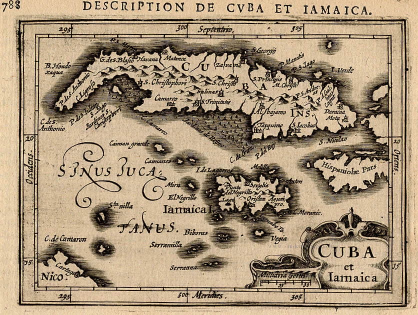
Cuba Insula.
Item Number: 32297 Authenticity Guarantee
Category: Antique maps > America > West Indies
Cuba & Jamaica by Barent Langenes.
Title: Cuba Insula.
Petrus Kaerius caela.
Engraver: Petrus Kaerius.
Date of the first edition: 1598.
Date of this map: c. 1600.
Copper engraving, printed on paper.
Image size: 85 x 125mm (3¼ x 5 inches).
Sheet size: 115 x 180mm (4½ x 7 inches).
Verso: French text.
Condition: Excellent.
Condition Rating: A+.
From: Barent Langenes. Thrésor de Chartes. Den Haag, Albert Hendricks for Cornelis Claesz., c. 1600. (Van der Krogt 3, 341:11)
Barent Langenes ans his Caert-Thresoor
Barent Langenes, a Dutch bookseller and publisher of Middelburg (Zeeland), about whom little is known, was the first printer of the Caert-Thresoor (1598), a small-size atlas with an exciting history. This atlas had many editions in Dutch, Latin, French, and German, later brought out by Cornelis Claesz and Jodocus Hondius. Langenes was involved in the first two Dutch editions.
The Caert-Thresoor, is a collection of maps to which the text was adapted and not the reverse, as in the case with many geographical studies. The most exciting maps are those of the English and the Dutch in arctic waters, searching for the route to China (Northwest Passage). It records the departure of the Dutch third fleet in the spring of 1596 but not the return of survivors of this tragic voyage in August 1597. This atlas sets a new standard for minor atlases. Moreover, it was affordable to the citizens of the lowest income.
The text was rewritten, first by Petrus Bertius and reissued in 1600, and then again by Jacobus Viverius in 1609. The edition with the original basic text continued to be published until 1609, the year of Cornelis Claesz’s death.
Related items

Pas Kaart vande Zuyd Kust van Cuba en van Geheel Yamaica en and're Bygeleegen Plaatsen ... 1697-1709
Cuba - Jamaica by Johannes van Keulen
[Item number: 11219]
Cuba et Iamaica. 1618
Cuba and Jamaica,by Bertius P.
[Item number: 18315]

Cuba Insula et Iamaica. 1607
Antilles: Cuba - Jamaica, by Cornelis van Wytfliet.
[Item number: 26502]

Iamaica. - [Above map :] Descrittione del l'Isola Iamaica hora detta di S. Iacopo. 1590
Jamaica by Tommaso Porcacchi.
[Item number: 29823]

Rare first edition
Cuba Insula [on sheet with] Hispaniola Insula [and] Insula Iamaica [and] Ins. S. Ioannis [and] I.S. Margareta cum Confiniis 1606
Cuba and Antilles by Henricus Hondius.
[Item number: 32055]