
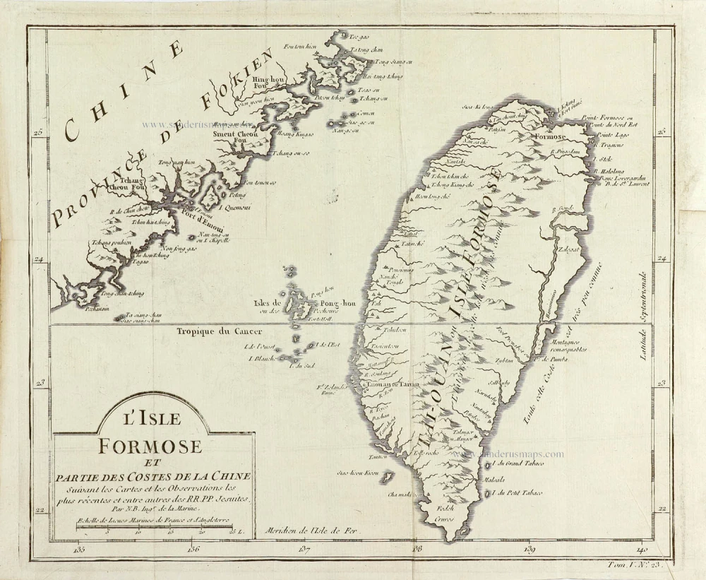
Taiwan (Formosa), by Jacques Nicolas Bellin. 1763
Jacques-Nicolas Bellin (1703-1772)
Jacques-Nicolas Bellin, a French geographer, was among the most important mapmakers of the eighteenth century. In 1721, at the age of 18, he was appointed hydrographer of the Ministry of the Navy following the French hydrographic office's creation and the Dépot of charts and plans of the Navy. Appointed hydrographic engineer in August 1741. Member of the Academy of the Navy and the Royal Society of London.
Over the course of a 50-year career, he drew the maps of several major works of his time such as Histoire et description générale de la Nouvelle-France de Charlevoix (1744); Histoire générale des voyages de l'Abbé Prévost (published between 1746 and 1759) ); Neptune François (1753), Hydrographie Françoise (1756-1765), and Petit Atlas Français (1763) - reissued as Petit Atlas Maritime (1765). He is the most copied cartographer of the 18th century.
His maps of Canada and the French territories of North America are of considerable value. This is all the more remarkable since, an archetype of the cabinet cartographer, Bellin never came to America. For his cartography of the St. Lawrence River, he entrusted handwritten maps to navigators to correct and enrich. With each return of these maps, he was updating his knowledge. Two basic needs drive its cartography of North America: to secure navigation on the St. Lawrence River and to claim for France the lands explored by the French in the Great Lakes region and along the Mississippi River.
Jacques-Nicolas Bellin died on March 21, 1772, in Versailles. In the burial certificate, he is described as "the first engineer of the navy and the deposit of plans, royal censor of the academy of navy and the royal society of London".
L'Isle Formose et Partie des Costes de la Chine.
Item Number: 29304 Authenticity Guarantee
Category: Antique maps > Asia > China
Old, antique map of Taiwan (Formosa), by Jacques Nicolas Bellin.
Title: L'Isle Formose et Partie des Costes de la Chine.
Suivant les Cartes et les Observations les plus récentes et entre autres des RR. PP. Jesiutes.
Par N.B. Ingr de la Marine.
Engraver: Jacob van der Schley.
Date of the first edition: 1749.
Date of this map: 1763.
Copper engraving, printed on paper.
Map size: 245 x 280mm (9.65 x 11.02 inches).
Sheet size: 260 x 310mm (10.24 x 12.2 inches).
Verso: Blank.
Condition: Folds as issued, excellent.
Condition Rating: A+.
From: Le Petit Atlas François. Paris, 1763.
Jacques-Nicolas Bellin (1703-1772)
Jacques-Nicolas Bellin, a French geographer, was among the most important mapmakers of the eighteenth century. In 1721, at the age of 18, he was appointed hydrographer of the Ministry of the Navy following the French hydrographic office's creation and the Dépot of charts and plans of the Navy. Appointed hydrographic engineer in August 1741. Member of the Academy of the Navy and the Royal Society of London.
Over the course of a 50-year career, he drew the maps of several major works of his time such as Histoire et description générale de la Nouvelle-France de Charlevoix (1744); Histoire générale des voyages de l'Abbé Prévost (published between 1746 and 1759) ); Neptune François (1753), Hydrographie Françoise (1756-1765), and Petit Atlas Français (1763) - reissued as Petit Atlas Maritime (1765). He is the most copied cartographer of the 18th century.
His maps of Canada and the French territories of North America are of considerable value. This is all the more remarkable since, an archetype of the cabinet cartographer, Bellin never came to America. For his cartography of the St. Lawrence River, he entrusted handwritten maps to navigators to correct and enrich. With each return of these maps, he was updating his knowledge. Two basic needs drive its cartography of North America: to secure navigation on the St. Lawrence River and to claim for France the lands explored by the French in the Great Lakes region and along the Mississippi River.
Jacques-Nicolas Bellin died on March 21, 1772, in Versailles. In the burial certificate, he is described as "the first engineer of the navy and the deposit of plans, royal censor of the academy of navy and the royal society of London".
Related items

Die Insel Formosa neu abgemessen auf Befehl Kaysers Kamhi. 1726
Taiwan by J. Stöcklein. (Formosa)
[Item number: 30143]

Extremely rare first edition
Mapa de la parte de la Isla Formosa, perteneciente al Emperador de la China sacado por Orden de su Mag. 1753-57
Formosa (Taiwan) by a French missionary, engraved by Gonzalez.
[Item number: 33076]
new