
The first accurate European map of Japan.
Japan by Abraham Ortelius. 1609
The item displayed on this page has been sold. However, we have a similar map in stock:
Japan by Abraham Ortelius. 1612
Iaponiae Insulae Descriptio.
[Item number: 31043]
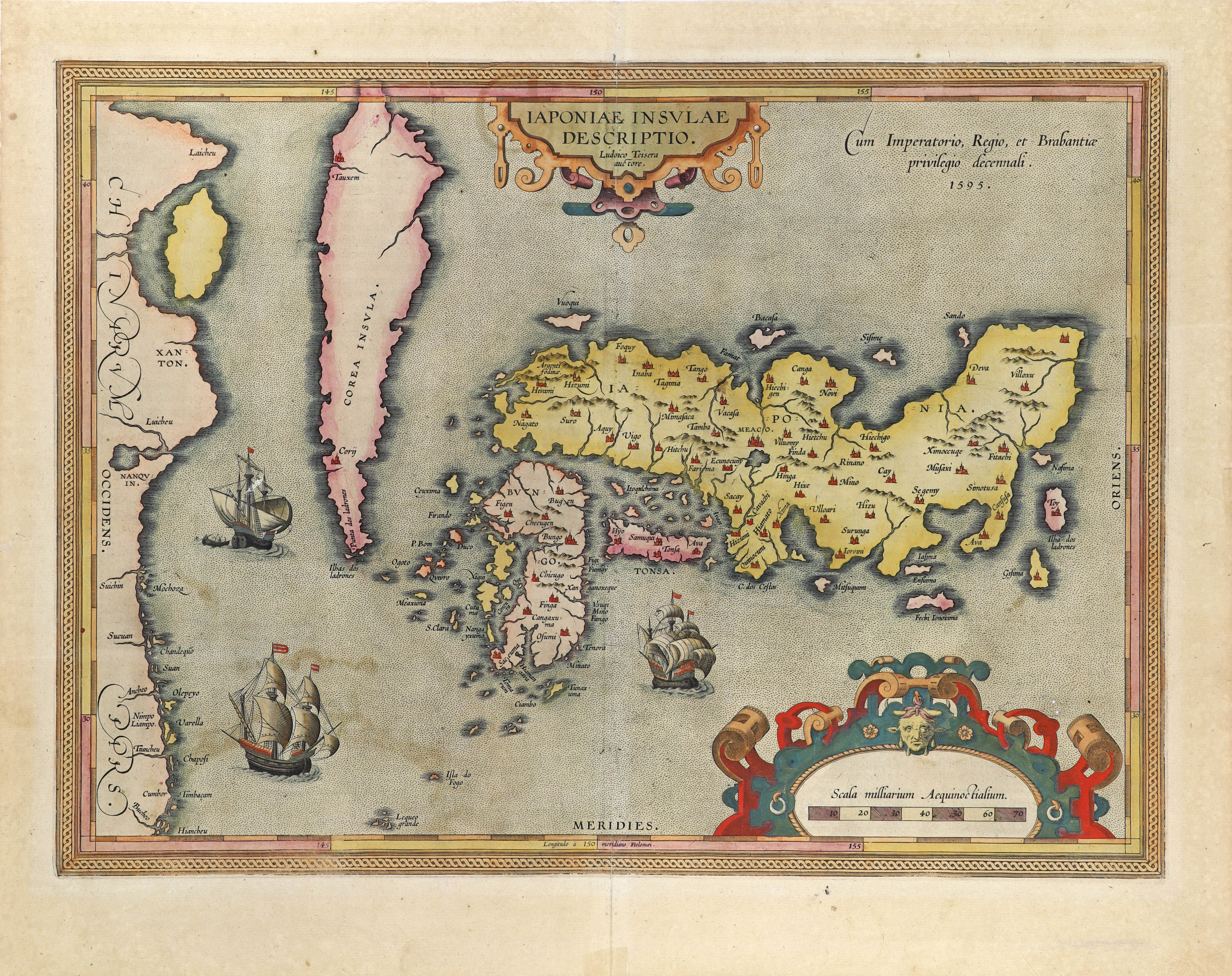
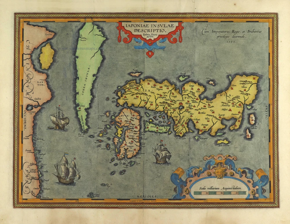
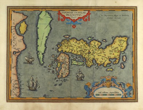
Teixeira's map of Japan represents a combination of Portuguese and Japanese information, in which the latter dominates. The three central Islands, Kyushu and Honshu, are separated. For the first time in Western cartography, the eastern sections of the country, which Europeans had not yet visited, are also represented. Important place names are included, too. On the other hand, many names of places that the merchants and missionaries commonly visited need to be added. However, they had been prominent on European maps up to this time, based purely on their observations.
The Ortelius / Texeira type remained determinant until the middle of the seventeenth century. Then, in contrast to the later types, it was taken over by its imitators almost without change. (Walter).
Abraham Ortelius (1527-1598)
The maker of the 'first atlas', the Theatrum Orbis Terrarum (1570), was born on 4 April 1527 into an old Antwerp family. He learned Latin and studied Greek and mathematics.
Abraham and his sisters, Anne and Elizabeth, took up map colouring. Ortelius was admitted to the Guild of St. Luke as an "illuminator of maps." In addition to colouring maps, Ortelius was a dealer in antiques, coins, maps, and books, and the book and map trade gradually became his primary occupation.
Business went well because his means allowed him to amass an extensive collection of medals, coins, and antiques, as well as a library of many volumes. In addition, he travelled extensively, visited Italy and France, made contacts with scholars and editors everywhere, and maintained extensive correspondence with them.
In 1564, he published his first map, a large and ambitious world wall map. The inspiration for this map may well have been Gastaldi's large world map. In 1565, he published a map of Egypt and a map of the Holy Land; a large map of Asia followed.
In 1568, the production of individual maps for his atlas Theatrum Orbis Terrarum was already in full swing. He completed the atlas in 1569, and in May 1570, it was available for sale. It was one of the most expensive books ever published.
This first edition contained seventy maps on fifty-three sheets. Franciscus Hogenberg engraved the maps.
Later editions included Additamenta (additions), resulting in Ortelius' historical atlas, the Parergon, which is mainly bound together with the atlas. The Parergon can be considered a truly original work by Ortelius, who drew the maps based on his research.
The importance of the Theatrum Orbis Terrarum for geographical knowledge in the last quarter of the sixteenth century is difficult to overemphasise. Nothing was like it until Mercator's atlas appeared twenty-five years later. Demand for the Theatrum was remarkable. Some 24 editions appeared during Ortelius's lifetime, and another 10 after he died in 1598. Editions were published in Dutch, German, French, Spanish, English, and Italian. The number of map sheets grew from 53 in 1570 to 167 in the last edition in 1612.
In 1577, engraver Philip Galle and poet-translator Pieter Heyns published the first pocket-sized edition of the Theatrum, the Epitome. The work was trendy. Over thirty editions of this Epitome were published in different languages.
Ortelius is also remembered for an early idea resembling continental drift: he suggested that the Americas, Europe, and Africa may once have been joined together before separating over time. His work helped shape the development of modern geography and mapmaking.
Iaponiae Insulae Descriptio.
Item Number: 28433 Authenticity Guarantee
Category: Antique maps > Asia > Japan
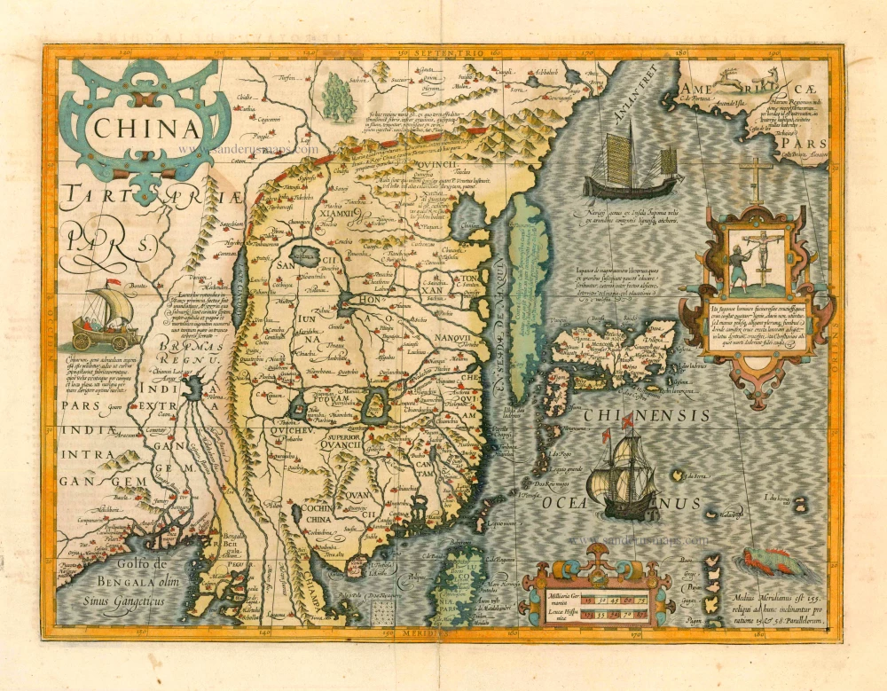
Japan - Korea, by Abraham Ortelius.
Korea is shown as an island.
Title: Iaponiae Insulae Descriptio.
Ludoico Teisera Auctore.
Cum Imperatorio, Regio, et Brabantiae privilegio decennali. 1595.
Cartographer: Luis Teixeira.
Date of the first edition: 1595.
Date of this map: 1595.
Date on map: 1595.
Copper engraving, printed on paper.
Image size: 350 x 485mm (13.78 x 19.09 inches).
Sheet size: 445 x 535mm (17.52 x 21.06 inches).
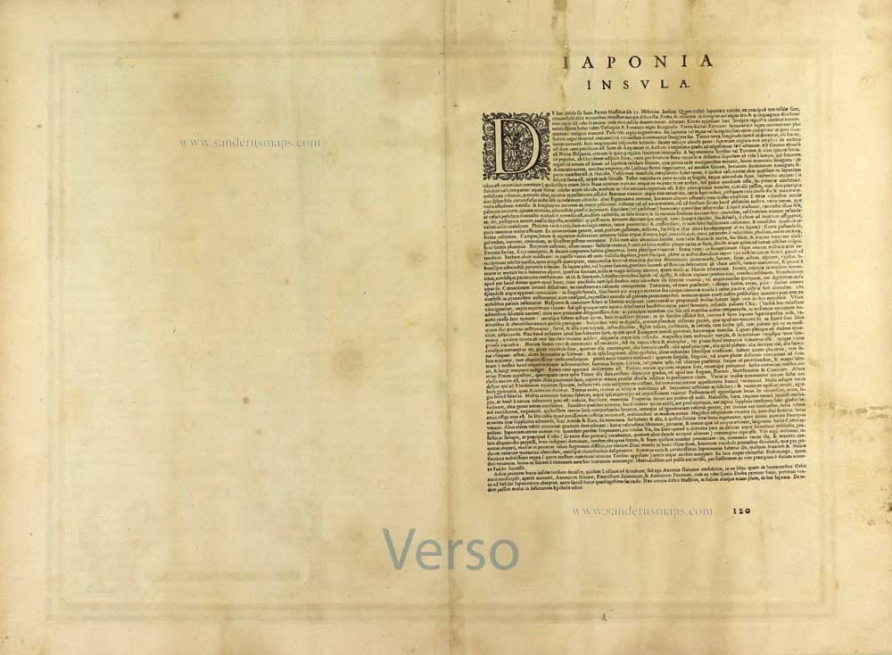
Verso: Latin text.
Condition: Original coloured, heigthened in gold.
Condition Rating: A+.
From: Theatrum Orbis Terrarum. Antwerp, Plantin Press, 1595. (Van der Krogt 3, 31:051)
Teixeira's map of Japan represents a combination of Portuguese and Japanese information, in which the latter dominates. The three central Islands, Kyushu and Honshu, are separated. For the first time in Western cartography, the eastern sections of the country, which Europeans had not yet visited, are also represented. Important place names are included, too. On the other hand, many names of places that the merchants and missionaries commonly visited need to be added. However, they had been prominent on European maps up to this time, based purely on their observations.
The Ortelius / Texeira type remained determinant until the middle of the seventeenth century. Then, in contrast to the later types, it was taken over by its imitators almost without change. (Walter).
Abraham Ortelius (1527-1598)
The maker of the 'first atlas', the Theatrum Orbis Terrarum (1570), was born on 4 April 1527 into an old Antwerp family. He learned Latin and studied Greek and mathematics.
Abraham and his sisters, Anne and Elizabeth, took up map colouring. Ortelius was admitted to the Guild of St. Luke as an "illuminator of maps." In addition to colouring maps, Ortelius was a dealer in antiques, coins, maps, and books, and the book and map trade gradually became his primary occupation.
Business went well because his means allowed him to amass an extensive collection of medals, coins, and antiques, as well as a library of many volumes. In addition, he travelled extensively, visited Italy and France, made contacts with scholars and editors everywhere, and maintained extensive correspondence with them.
In 1564, he published his first map, a large and ambitious world wall map. The inspiration for this map may well have been Gastaldi's large world map. In 1565, he published a map of Egypt and a map of the Holy Land; a large map of Asia followed.
In 1568, the production of individual maps for his atlas Theatrum Orbis Terrarum was already in full swing. He completed the atlas in 1569, and in May 1570, it was available for sale. It was one of the most expensive books ever published.
This first edition contained seventy maps on fifty-three sheets. Franciscus Hogenberg engraved the maps.
Later editions included Additamenta (additions), resulting in Ortelius' historical atlas, the Parergon, which is mainly bound together with the atlas. The Parergon can be considered a truly original work by Ortelius, who drew the maps based on his research.
The importance of the Theatrum Orbis Terrarum for geographical knowledge in the last quarter of the sixteenth century is difficult to overemphasise. Nothing was like it until Mercator's atlas appeared twenty-five years later. Demand for the Theatrum was remarkable. Some 24 editions appeared during Ortelius's lifetime, and another 10 after he died in 1598. Editions were published in Dutch, German, French, Spanish, English, and Italian. The number of map sheets grew from 53 in 1570 to 167 in the last edition in 1612.
In 1577, engraver Philip Galle and poet-translator Pieter Heyns published the first pocket-sized edition of the Theatrum, the Epitome. The work was trendy. Over thirty editions of this Epitome were published in different languages.
Ortelius is also remembered for an early idea resembling continental drift: he suggested that the Americas, Europe, and Africa may once have been joined together before separating over time. His work helped shape the development of modern geography and mapmaking.
Related items
With Korea as an island.
China 1619
China, Korea and Japan by J. Hondius.
[Item number: 6494]

Iapan. 1602
Japan by Langenes, published by Bertius P.
[Item number: 12487]

Iaponiae Nova Desciptio. 1641
Japan & Korea by Johannes Janssonius
[Item number: 26441]

Nieuwe kaart van het Eyland Japan. 1726
Japan by François Valentyn (Valentijn).
[Item number: 26876]

L'Empire du Japon Divisé en sept principales parties, savoir, Ochio, Quanto, Jetsegen, Jetsen, Jamaisoit, Xicoco et Ximo, et subdivisé en soixante et six Royaumes. 1776-79
Japan, by Francesco Santini.
[Item number: 26975]

China Veteribus Sinarum Regio Nunc Incolis Tame Dicta. 1649-55
China - Japan - Korea, by Willem & Joan Blaeu.
[Item number: 27043]
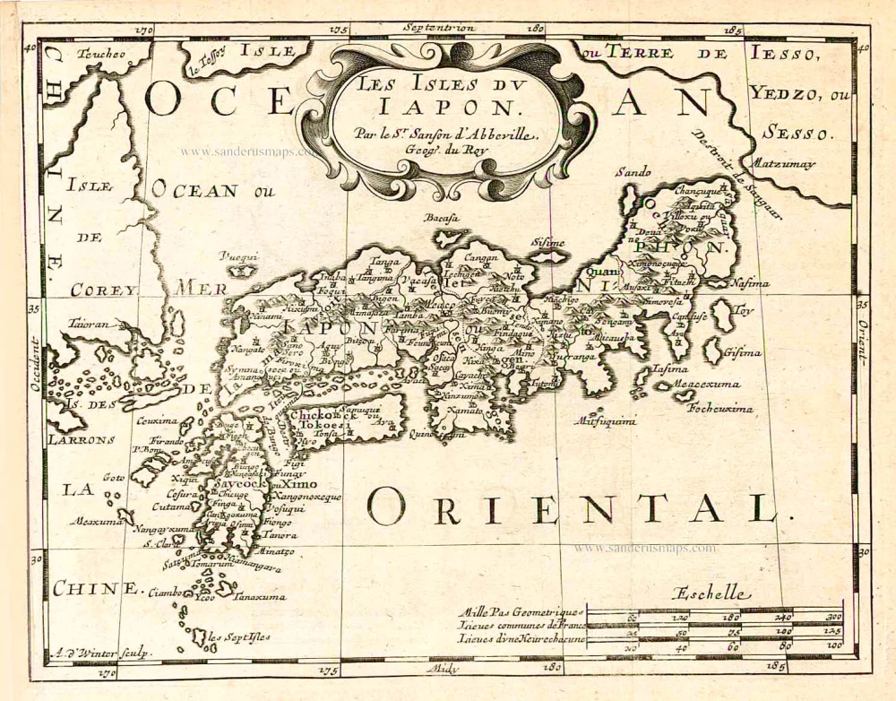
Les Isles du Iapon. 1683
Japan, by Nicolas Sanson.
[Item number: 27081]

Very nice old colour
Iaponia. 1623
Japan, Jodocus Hondius.
[Item number: 27819]

L'Empire du Japon, tiré des Cartes des Japonnois. 1719
Japan, by Z. Châtelain.
[Item number: 29379]

First map to show Korea as a peninsula. Excellent condition.
Iaponia Regnum. 1655-1659
Japan & Korea by Joan Blaeu.
[Item number: 29853]

Vue et Description de la Ville de Meaco, Capitale du Japon avec d'autres Particularitez du Pays. 1719
Kyoto - Decima (Japan), by Z. Châtelain.
[Item number: 32303]
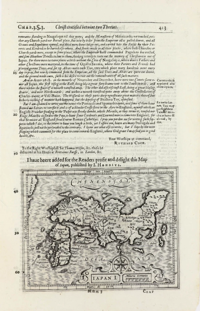
Iapan I. 1625
Japan by Jodocus Hondius, published by Samuel Purchas
[Item number: 32418]