
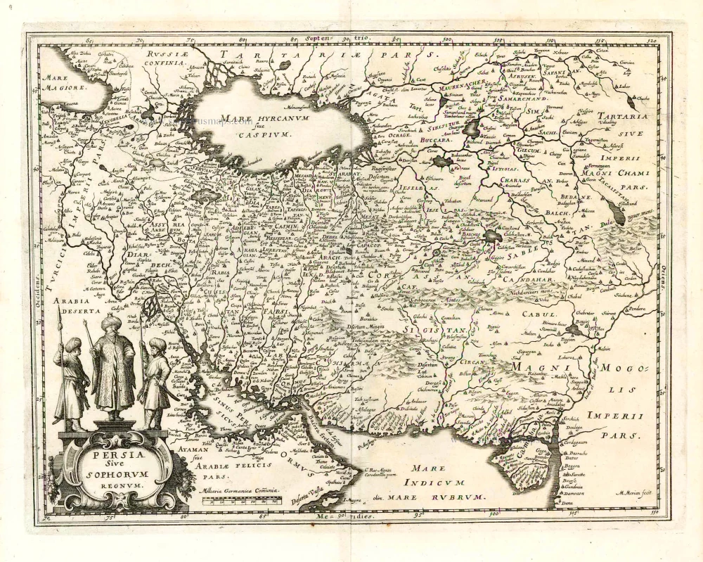
Arabia and Persia by Frederick de Wit. ca. 1680

Frederick de Wit (1630-1706)
The engraver and map-seller, Frederick de Wit, was born in Gouda (Netherlands) in 1630 as a son of Hendrick Fredericksz de Wit. Through his marriage with Maria van der Waag of Amsterdam in 1661, he obtained citizenship of the city where he had been working since 1648 and where he became one of the most famous engravers of maps of the second half of the 17th century. Although De Wit was a Catholic, which meant that he was not favoured at the time by the city council, he was awarded the honour of being listed as one of the "excellent citizens" on the roll of the city council in the years 1694-1704. However, his name was not written in the Guild of St. Luke book before 1664. At that time, he lived on the Kalverstraat "in de Witte Pascaert", where he stayed until his death in 1706. His earliest dates on maps engraved are 1659 (Regni Daniae) and 1660 (World map).
Frederick de Wit published several world atlases, a sea atlas, and an atlas of the Netherlands.
The dating of the maps is difficult. However, as a privilege was granted in 1689, the annotation 'cum privilegio' marks an edition after 1688.
Around 1700, Frederick de Wit entered the market with a town atlas. He produced two volumes with a total of 260 plans and views. Most were printed from plates used for Janssonius and Blaeu town atlases.
After he died in 1706, his widow continued the shop until 1709. The plates and stock of De Wit's atlas were sold to Covens & Mortier in 1710, who sold the atlas for an extended period.
Nova Persiae Armeniae Natoliae et Arabiae.
Item Number: 32271 Authenticity Guarantee
Category: Antique maps > Asia > Middle East
Arabia and Persia by Frederick de Wit.
Title: Nova Persiae Armeniae Natoliae et Arabiae.
Descriptio per F. de Wit.
t'Amsterdam by Frederick de Wit inde Kalverstraet inde Witte Pascaert.
Date of the first edition: ca. 1662-66.
Date of this map: ca. 1680.
Copper engraving, printed on paper.
Image size: 475 x 555mm (18¾ x 21¾ inches).
Sheet size: 525 x 595mm (20¾ x 23½ inches).
Verso: Blank.
Condition: Hand-coloured, excellent.
Condition Rating: A+.
From: Atlas. Amsterdam, Frederick de Wit,1682-1689. (Carhart p. 142 A28a)
Frederick de Wit (1630-1706)
The engraver and map-seller, Frederick de Wit, was born in Gouda (Netherlands) in 1630 as a son of Hendrick Fredericksz de Wit. Through his marriage with Maria van der Waag of Amsterdam in 1661, he obtained citizenship of the city where he had been working since 1648 and where he became one of the most famous engravers of maps of the second half of the 17th century. Although De Wit was a Catholic, which meant that he was not favoured at the time by the city council, he was awarded the honour of being listed as one of the "excellent citizens" on the roll of the city council in the years 1694-1704. However, his name was not written in the Guild of St. Luke book before 1664. At that time, he lived on the Kalverstraat "in de Witte Pascaert", where he stayed until his death in 1706. His earliest dates on maps engraved are 1659 (Regni Daniae) and 1660 (World map).
Frederick de Wit published several world atlases, a sea atlas, and an atlas of the Netherlands.
The dating of the maps is difficult. However, as a privilege was granted in 1689, the annotation 'cum privilegio' marks an edition after 1688.
Around 1700, Frederick de Wit entered the market with a town atlas. He produced two volumes with a total of 260 plans and views. Most were printed from plates used for Janssonius and Blaeu town atlases.
After he died in 1706, his widow continued the shop until 1709. The plates and stock of De Wit's atlas were sold to Covens & Mortier in 1710, who sold the atlas for an extended period.
Related items

Persici sive Sophorum Regni Typus 1612
Persia, by Abraham Ortelius.
[Item number: 22957]

Tabula Asiae V. 1571
Persia, by Strabo - S. Munster.
[Item number: 25654]
Persia Sive Spohorum Regnum. 1638
Persia, by Matthäus Merian.
[Item number: 26598]

[Persia]. 1724-26
Persia by François Valentyn (Valentijn)
[Item number: 26899]

Persia Sive Sophorum Regnum. 1664-65
Persia, by Willem Blaeu.
[Item number: 27084]

Description de l'Empire du Sophi des Perses 1658
Persia by Nicolas Sanson.
[Item number: 28477]

Persia Sive Sophorum Regnum. 1643
Persia, by Willem Blaeu.
[Item number: 30197]

Persicum Regnum. 1618
Persia by Petrus Bertius, published by Jodocus Hondius II.
[Item number: 32142]

Ormus Regnum. 1618
Hormus - Persian Gulf by Petrus Bertius, published by Jodocus Hondius II.
[Item number: 32143]

Scarce
De Persiaanze Zee Met de Eylanden Baharem, Queixome en Ormus, tussen Arabie en Persie, tot aan Dio en Suratte. 1707
Persian Gulf - Arabia by Pieter Van der Aa.
[Item number: 32322]

De Persiaanze Zee met d'Eylanden in deselve Tussen de Kusten van Arabie en Persie gelegen tot aan den Indus Vloed De Voorkusten van Guzaratte en Malabaar Tot aan Kaap Komoryn. 1707
Persian Gulf with Southern Arabia, by Pieter Van der Aa.
[Item number: 32348]

Scarce
De Kusten van Arabie, het Roode Meer, en Persize Zee van Bassora voorby t' Nau van Ormus Tot aan den Indus, Guzaratte en Kaap Comorin. 1707
Persian Gulf with Arabia, by Pieter Van der Aa.
[Item number: 32349]

Persici vel Sophorum Regni Typus. 1641
Persia by Henricus Hondius
[Item number: 32932]

Persici sive Sophorum Regni Typus. 1572
Persia by Abraham Ortelius.
[Item number: 33079]
new