
Scarce
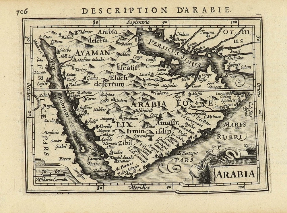
Persian Gulf with Arabia, by Pieter Van der Aa. 1707

Pieter van der Aa (Leiden, 1659-1733)
Pieter van der Aa was already in 1682 owner of a bookshop and auction house. During his life, he has published an enormous amount of printed material.
After 1700, van der Aa increasingly specialised in books on geography and travel.
He published composite atlases, a series of geographical descriptions of European countries, and some very spectacular works. Between 1706 and 1708 he published the Naauweurige versameling der gedenkwaardigste zee- en land-reysen, in 28 volumes.
Many of Van der Aa’s publications are richly illustrated with maps and plates. He took over many copperplates and prints from other publishers such as Carel Allard and Frederik De Wit. The composite atlases that appeared from his workshop contain a curious mixture of his own material, copies of maps from other publishers, and reprints made from old copper plates, now with his own imprint.
The Galérie agréable du monde, was completed in 1729, and comprised 66 parts, bound in 27 volumes. Van der Aa presented it as a good investment; after publication, the antiquarian value of the work would double, the more so since it was printed in a limited edition of only one hundred copies.
De Kusten van Arabie, het Roode Meer, en Persize Zee van Bassora voorby t' Nau van Ormus Tot aan den Indus, Guzaratte en Kaap Comorin.
Item Number: 32349 Authenticity Guarantee
Category: Antique maps > Asia > India - Ceylon
Persian Gulf with Southern Arabia.
Title: De Kusten van Arabie, het Roode Meer, en Persize Zee van Bassora voorby t' Nau van Ormus Tot aan den Indus, Guzaratte en Kaap Comorin.
Uytgevoerd te Leyden door Pieter Vander Aa met Privilegie. - Duarte de Menezes.
Date of the first edition: 1707.
Date of this map: 1707.
Copper engraving, printed on paper.
Image size: 155 x 220mm (6 x 8¾ inches).
Sheet size: 175 x 290mm (7 x 11½ inches).
Verso: Blank.
Condition: Excellent.
Condition Rating: A+.
From: Naaukeurige Versameling der gedenk-waardigste Zee- en landreysen na Oost en West-Indien. Leiden, Pieter Van der Aa, 1707.
The map shows the Persian Gulf with Arabia, the Gulf of Aden, the Red Sea, and the coasts of Persia and India.
Illustrates the accounts of Duarte de Menezes.
Pieter van der Aa (Leiden, 1659-1733)
Pieter van der Aa was already in 1682 owner of a bookshop and auction house. During his life, he has published an enormous amount of printed material.
After 1700, van der Aa increasingly specialised in books on geography and travel.
He published composite atlases, a series of geographical descriptions of European countries, and some very spectacular works. Between 1706 and 1708 he published the Naauweurige versameling der gedenkwaardigste zee- en land-reysen, in 28 volumes.
Many of Van der Aa’s publications are richly illustrated with maps and plates. He took over many copperplates and prints from other publishers such as Carel Allard and Frederik De Wit. The composite atlases that appeared from his workshop contain a curious mixture of his own material, copies of maps from other publishers, and reprints made from old copper plates, now with his own imprint.
The Galérie agréable du monde, was completed in 1729, and comprised 66 parts, bound in 27 volumes. Van der Aa presented it as a good investment; after publication, the antiquarian value of the work would double, the more so since it was printed in a limited edition of only one hundred copies.
Related items

De Roode Zee met de Kusten van Arabien; en het Naauw tussen Aden en Zeila tot aan Bassora. 1714
Arabia, by Pieter van der Aa.
[Item number: 26103]

Tabula Asiae VI. 1597
Arabia, by Giovanni Magini.
[Item number: 26519]

Carte de la coste d'Arabie, Mer Rouge, et Golfe du Perse. 1750
Arabia by Jacques Nicolas Bellin.
[Item number: 28188]

Carte Particuliere de l'Egypte, de la Nubie et de l'Abyssinie. 1719
Northeast Africa & Arabia, by Z. Châtelain.
[Item number: 29371]
Arabia 1618
Arabia by Petrus Bertius, published by Jodocus Hondius II.
[Item number: 32141]

Nova Persiae Armeniae Natoliae et Arabiae. ca. 1680
Arabia and Persia by Frederick de Wit.
[Item number: 32271]

De Persiaanze Zee met d'Eylanden in deselve Tussen de Kusten van Arabie en Persie gelegen tot aan den Indus Vloed De Voorkusten van Guzaratte en Malabaar Tot aan Kaap Komoryn. 1707
Persian Gulf with Southern Arabia, by Pieter Van der Aa.
[Item number: 32348]

Persici vel Sophorum Regni Typus. 1641
Persia by Henricus Hondius
[Item number: 32932]