
Arabia by Jacques Nicolas Bellin. 1750

Tibbetts: "This map is perhaps the original of the maps appearing in Prévost".
Jacques-Nicolas Bellin (1703-1772)
Jacques-Nicolas Bellin, a French geographer, was among the most important mapmakers of the eighteenth century. In 1721, at the age of 18, he was appointed hydrographer of the Ministry of the Navy following the French hydrographic office's creation and the Dépot of charts and plans of the Navy. Appointed hydrographic engineer in August 1741. Member of the Academy of the Navy and the Royal Society of London.
Over the course of a 50-year career, he drew the maps of several major works of his time such as Histoire et description générale de la Nouvelle-France de Charlevoix (1744); Histoire générale des voyages de l'Abbé Prévost (published between 1746 and 1759) ); Neptune François (1753), Hydrographie Françoise (1756-1765), and Petit Atlas Français (1763) - reissued as Petit Atlas Maritime (1765). He is the most copied cartographer of the 18th century.
His maps of Canada and the French territories of North America are of considerable value. This is all the more remarkable since, an archetype of the cabinet cartographer, Bellin never came to America. For his cartography of the St. Lawrence River, he entrusted handwritten maps to navigators to correct and enrich. With each return of these maps, he was updating his knowledge. Two basic needs drive its cartography of North America: to secure navigation on the St. Lawrence River and to claim for France the lands explored by the French in the Great Lakes region and along the Mississippi River.
Jacques-Nicolas Bellin died on March 21, 1772, in Versailles. In the burial certificate, he is described as "the first engineer of the navy and the deposit of plans, royal censor of the academy of navy and the royal society of London".
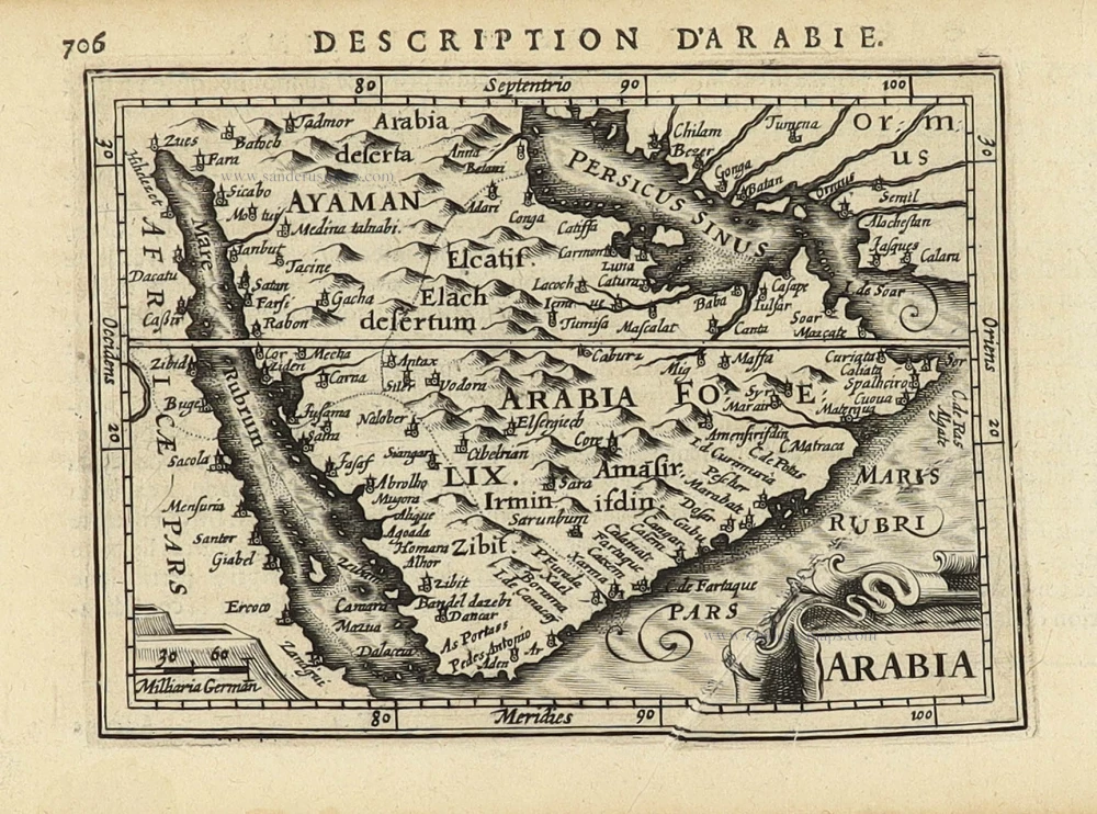
Carte de la coste d'Arabie, Mer Rouge, et Golfe du Perse.
Item Number: 28188 Authenticity Guarantee
Category: Antique maps > Asia > Middle East
Old, antique map of Arabia, by Jacques Nicolas Bellin.
Title: Carte de la coste d'Arabie, Mer Rouge, et Golfe du Perse.
Tirée de la Carte de l'Ocean Oriental publiée en 1740. Par ordre de M. le Comte de Maurepas.
J. V. Schley direx.
Augmentée sur des Remarques Particulieres et dressée sur des Observations Astronomiques.
Kaart van de Kust van Arabië, de Roode Zee en de Golf van Persië.
Gemaakt na de Fransse Kaart van den Ooster-Oceaan, uitgegeeven A° 1740 op Bevel van den Hre Grave de Maurepas:
Vermeerderd op byzondere Aanmerkingen, en geschikt volgens Sterrekundige Waarnemingen.
Date of the first edition: 1750.
Date of this map: 1750.
First state.
Engraver: Jacob van der Schley.
Copper engraving, printed on paper.
Size (not including margins): 235 x 250mm (9.25 x 9.84 inches).
Verso: Blank.
Condition: Folds as issued, excellent.
Condition Rating: A+.
References: Tibbetts, #267; Not in Khaled Al Ankary
From: Prévost d'Exiles A. Fr. Historische Beschryving der Reizen. Den Haag, P. De Hondt, 1747-80. Enlarged Dutch translation of the French edition of 1746-89. Part 10, 1750.
**********************
**********************
Old, antique map of Arabia, by Jacques Nicolas Bellin.
Title: Carte de la coste d'Arabie, Mer Rouge, et Golfe du Perse.
Tirée de la Carte de l'Ocean Oriental publiée en 1740. Par ordre de M. le Comte de Maurepas.
J. V. Schley direx.Augmentée sur des Remarques Particulieres et dressée sur des Observations Astronomiques.
Kaart van de Kust van Arabië, de Roode Zee en de Golf van Persië.
Gemaakt na de Fransse Kaart van den Ooster-Oceaan, uitgegeeven A° 1740 op Bevel van den Hre Grave de Maurepas:
Vermeerderd op byzondere Aanmerkingen, en geschikt volgens Sterrekundige Waarnemingen.
Engraver: Jacob van der Schley..
Date of the first edition: 1750.
Date of this map: 1750.
Copper engraving, printed on paper.
Size (not including margins): 235 x 250mm (9.25 x 9.84 inches).
Verso: Blank.
Condition: Folds as issued, excellent.
Condition Rating: A+.
References: Tibbetts, #267; Not in Khaled Al Ankary
From: Prévost d'Exiles A. Fr. Historische Beschryving der Reizen. Den Haag, P. De Hondt, 1747-80. Enlarged Dutch translation of the French edition of 1746-89. Part 10, 1750.
Tibbetts: "This map is perhaps the original of the maps appearing in Prévost".
Jacques-Nicolas Bellin (1703-1772)
Jacques-Nicolas Bellin, a French geographer, was among the most important mapmakers of the eighteenth century. In 1721, at the age of 18, he was appointed hydrographer of the Ministry of the Navy following the French hydrographic office's creation and the Dépot of charts and plans of the Navy. Appointed hydrographic engineer in August 1741. Member of the Academy of the Navy and the Royal Society of London.
Over the course of a 50-year career, he drew the maps of several major works of his time such as Histoire et description générale de la Nouvelle-France de Charlevoix (1744); Histoire générale des voyages de l'Abbé Prévost (published between 1746 and 1759) ); Neptune François (1753), Hydrographie Françoise (1756-1765), and Petit Atlas Français (1763) - reissued as Petit Atlas Maritime (1765). He is the most copied cartographer of the 18th century.
His maps of Canada and the French territories of North America are of considerable value. This is all the more remarkable since, an archetype of the cabinet cartographer, Bellin never came to America. For his cartography of the St. Lawrence River, he entrusted handwritten maps to navigators to correct and enrich. With each return of these maps, he was updating his knowledge. Two basic needs drive its cartography of North America: to secure navigation on the St. Lawrence River and to claim for France the lands explored by the French in the Great Lakes region and along the Mississippi River.
Jacques-Nicolas Bellin died on March 21, 1772, in Versailles. In the burial certificate, he is described as "the first engineer of the navy and the deposit of plans, royal censor of the academy of navy and the royal society of London".
Related items

Carte de l'Egypte de la Nubie de l'Abissinie &c. ca. 1730.
Northeast Africa & Arabia by Guillaume Delisle, published by Covens & Mortier
[Item number: 12721]

De Roode Zee met de Kusten van Arabien; en het Naauw tussen Aden en Zeila tot aan Bassora. 1714
Arabia, by Pieter van der Aa.
[Item number: 26103]

Tabula Asiae VI. 1597
Arabia, by Giovanni Magini.
[Item number: 26519]

Carte Particuliere de l'Egypte, de la Nubie et de l'Abyssinie. 1719
Northeast Africa & Arabia, by Z. Châtelain.
[Item number: 29371]
Arabia 1618
Arabia by Petrus Bertius, published by Jodocus Hondius II.
[Item number: 32141]

Ormus Regnum. 1618
Hormus - Persian Gulf by Petrus Bertius, published by Jodocus Hondius II.
[Item number: 32143]

Scarce
De Persiaanze Zee Met de Eylanden Baharem, Queixome en Ormus, tussen Arabie en Persie, tot aan Dio en Suratte. 1707
Persian Gulf - Arabia by Pieter Van der Aa.
[Item number: 32322]

De Persiaanze Zee met d'Eylanden in deselve Tussen de Kusten van Arabie en Persie gelegen tot aan den Indus Vloed De Voorkusten van Guzaratte en Malabaar Tot aan Kaap Komoryn. 1707
Persian Gulf with Southern Arabia, by Pieter Van der Aa.
[Item number: 32348]

Scarce
De Kusten van Arabie, het Roode Meer, en Persize Zee van Bassora voorby t' Nau van Ormus Tot aan den Indus, Guzaratte en Kaap Comorin. 1707
Persian Gulf with Arabia, by Pieter Van der Aa.
[Item number: 32349]