
Arabia by Gerard de Jode. 1593


Gerard and Cornelis de Jode
Gerard de Jode (Judaeus) (1508(?)-1591), a native of Nijmegen, began his career as a printer and engraver in Antwerp about 1550. He lived near the Bourse on the Catelijne Veste, or on "de Catte". He was in regular contact with Christoffel Plantin, to whom he sold many prints and maps. De Jode's business, which must have been a major one among Antwerp's many booksellers and printers, was represented at the Frankfurt fair, where de Jode bought maps that he later copied or re-sold. Most of the maps sold by De Jode have prototypes of Italian or German origin. Apart from his many separately published maps, Gerard de Jode is known for his atlas, Speculum Orbis Terrarum, published in 1578. Part of the engraving was done by himself, and part by brothers Jan and Lucas van Doetecum.
Gerard de Jode and Abraham Ortelius, who partly lived as map sellers, were competitors and only sometimes on good terms.
After the death of Gerard de Jode in 1591, the business was carried on by his widow, Pascale van Gelder and his son, Cornelis (1568-1600). More a publisher than an engraver, the latter reissued the Speculum in 1593, adding new maps and revising others.
Despite all its deficiencies, the Speculum must have had a good reputation. It is mentioned alongside Mercator's Atlas and Ortelius's Theatrum in Petrus Montanus's preface to the Germania Inferior of Pieter van den Keere.
Giacomo Gastaldi (c. 1500 – 1566)
Giacomo Gastaldi was born in Villafranca, in Piedmont, to a wealthy family. Although he is considered one of the greatest cartographers of the sixteenth century, the events of his life and his professional training in the field of cartography are unknown to us until he arrives in Venice, where, in 1539, he obtained a perpetual printing privilege from the Venetian Senate.
One of the first Venetian contacts took place with the geographer and humanist Giovanni Battista Ramusio, with whom he collaborated. At the beginning of the 1540s, Gastaldi was already an established cartographer and began to work on a series of maps first published separately and then included in the Italian edition of Ptolemy's Geography of 1548 and others made from scratch.
By the 1540s, he had developed his distinctive style of copper engraving for his increasingly prolific output of maps. His maps were used as a source by many mapmakers, including Camocio, Bertelli, Forlani, Ramusio, Cock, Luchini and Ortelius.
With the support of his influential friendships, Gastaldi also obtained public positions: in 1549, the Council of Ten commissioned him to make a large map of Africa, for a wall from the armoury in the Doge's Palace and, again for the same room, one map of Asia and one of North America.
It is difficult to quantify the number of maps he produced; more than a hundred have been attributed to him.
Paolo Forlani collaborated for a long time with Gastaldi and published numerous counterfeits and not authorized editions.
Gastaldi died in Venice on 14 October 1566.
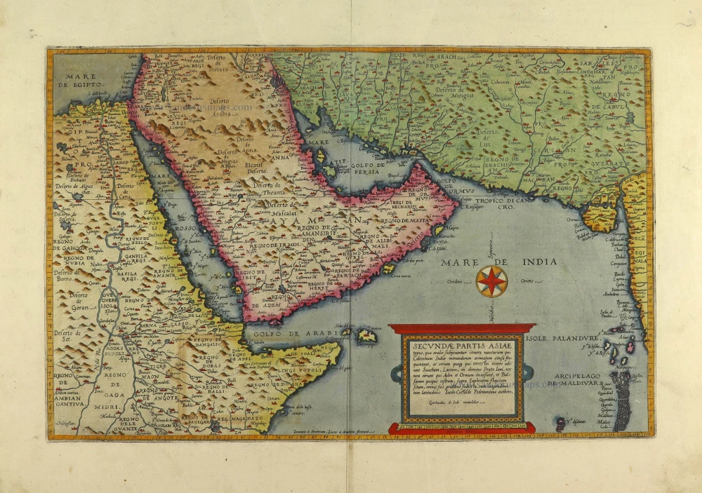
Secundae Partis Asiae.
Item Number: 28372 Authenticity Guarantee
Category: Antique maps > Asia > Middle East
Old, antique map of Arabia, by Gerard de Jode.
Title: Secundae Partis Asiae.
Typus, qua oculis subijciuntur itenera nautarum qui ...
Iacobo Castaldo Pedemontano authore.
Gerhardus de Iode excudebat.
Ioannes à deutecum, Lucas à deutecum, fecerunt.
Cartographer: Giacomo Gastaldi.
Engraver: Joannes and Lucas Van Doetecum.
Date of the first edition: 1578.
Date of this map: 1593.
Copper engraving, printed on paper.
Size (not including margins): 325 x 505mm (12.8 x 19.88 inches).
Size (including margins): 455 x 600mm (17.91 x 23.62 inches).
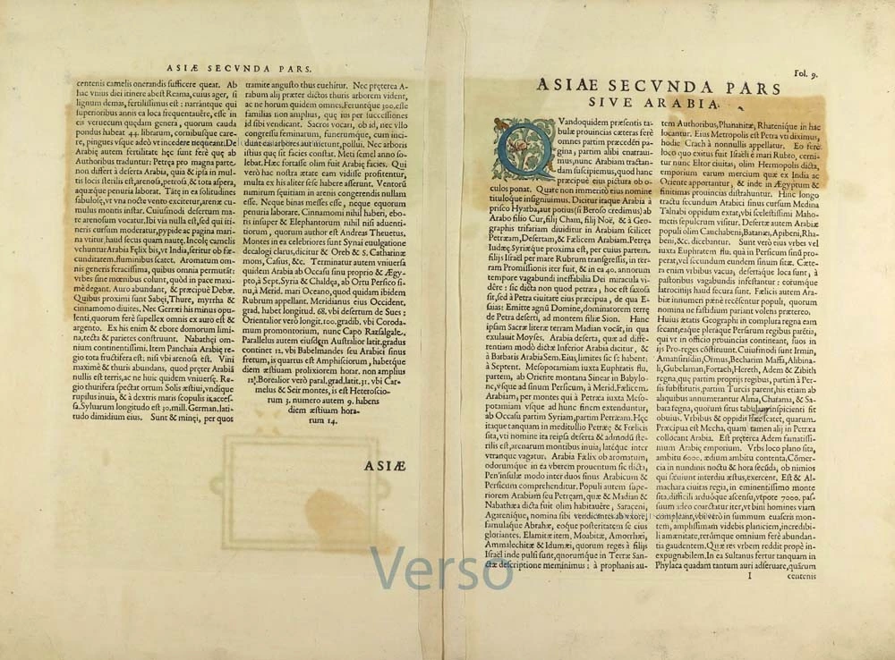
Verso: Latin text.
Condition: Original coloured, excellent.
Condition Rating: A+.
References: Van der Krogt 3, 8180:32; Karrow, 30/91.2: Khaled Al Ankary, #20; Tibbetts, #38; TNH Doet3, p. 37 #563
From: Speculum Orbis Terrae. Antwerpen, G. De Jode, 1593. (Van der Krogt 3, 2:02)
Gerard and Cornelis de Jode
Gerard de Jode (Judaeus) (1508(?)-1591), a native of Nijmegen, began his career as a printer and engraver in Antwerp about 1550. He lived near the Bourse on the Catelijne Veste, or on "de Catte". He was in regular contact with Christoffel Plantin, to whom he sold many prints and maps. De Jode's business, which must have been a major one among Antwerp's many booksellers and printers, was represented at the Frankfurt fair, where de Jode bought maps that he later copied or re-sold. Most of the maps sold by De Jode have prototypes of Italian or German origin. Apart from his many separately published maps, Gerard de Jode is known for his atlas, Speculum Orbis Terrarum, published in 1578. Part of the engraving was done by himself, and part by brothers Jan and Lucas van Doetecum.
Gerard de Jode and Abraham Ortelius, who partly lived as map sellers, were competitors and only sometimes on good terms.
After the death of Gerard de Jode in 1591, the business was carried on by his widow, Pascale van Gelder and his son, Cornelis (1568-1600). More a publisher than an engraver, the latter reissued the Speculum in 1593, adding new maps and revising others.
Despite all its deficiencies, the Speculum must have had a good reputation. It is mentioned alongside Mercator's Atlas and Ortelius's Theatrum in Petrus Montanus's preface to the Germania Inferior of Pieter van den Keere.
Giacomo Gastaldi (c. 1500 – 1566)
Giacomo Gastaldi was born in Villafranca, in Piedmont, to a wealthy family. Although he is considered one of the greatest cartographers of the sixteenth century, the events of his life and his professional training in the field of cartography are unknown to us until he arrives in Venice, where, in 1539, he obtained a perpetual printing privilege from the Venetian Senate.
One of the first Venetian contacts took place with the geographer and humanist Giovanni Battista Ramusio, with whom he collaborated. At the beginning of the 1540s, Gastaldi was already an established cartographer and began to work on a series of maps first published separately and then included in the Italian edition of Ptolemy's Geography of 1548 and others made from scratch.
By the 1540s, he had developed his distinctive style of copper engraving for his increasingly prolific output of maps. His maps were used as a source by many mapmakers, including Camocio, Bertelli, Forlani, Ramusio, Cock, Luchini and Ortelius.
With the support of his influential friendships, Gastaldi also obtained public positions: in 1549, the Council of Ten commissioned him to make a large map of Africa, for a wall from the armoury in the Doge's Palace and, again for the same room, one map of Asia and one of North America.
It is difficult to quantify the number of maps he produced; more than a hundred have been attributed to him.
Paolo Forlani collaborated for a long time with Gastaldi and published numerous counterfeits and not authorized editions.
Gastaldi died in Venice on 14 October 1566.
Related items
Carte de l'Egypte de la Nubie de l'Abissinie &c. ca. 1730.
Northeast Africa & Arabia by Guillaume Delisle, published by Covens & Mortier
[Item number: 12721]
Arabia 1618
Arabia, by Bertius P.
[Item number: 18293]
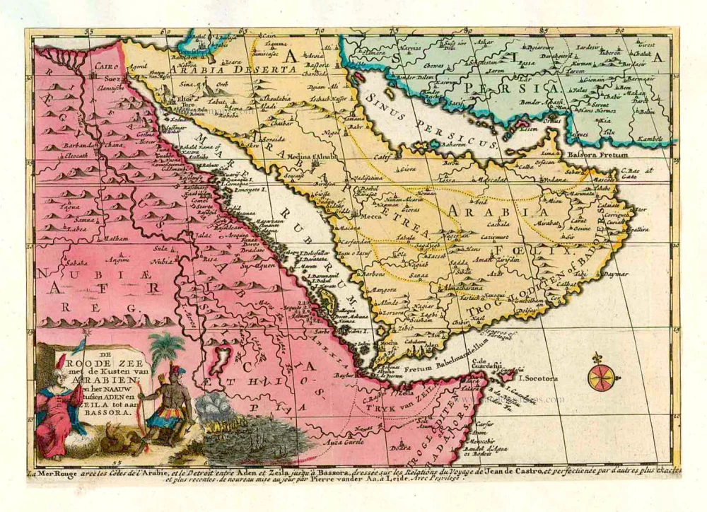
De Roode Zee met de Kusten van Arabien; en het Naauw tussen Aden en Zeila tot aan Bassora. 1714
Arabia, by Pieter van der Aa.
[Item number: 26103]
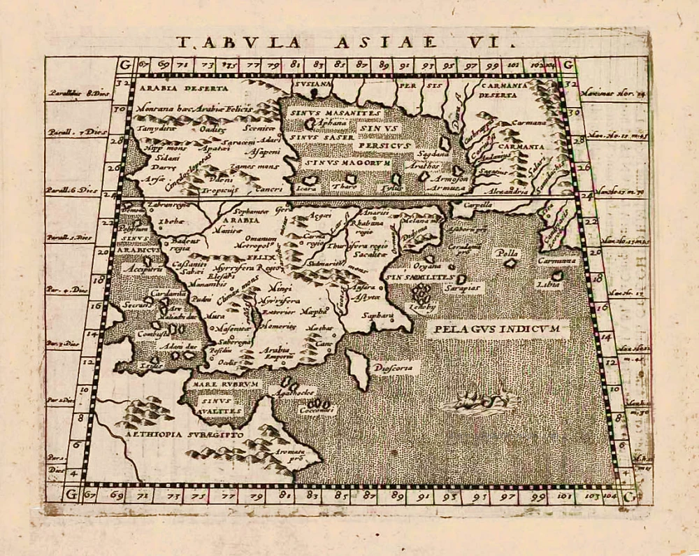
Tabula Asiae VI. 1597
Arabia, by Giovanni Magini.
[Item number: 26519]
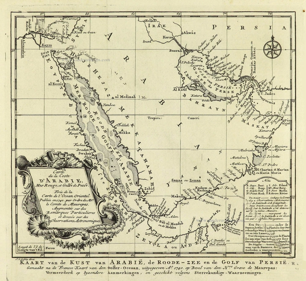
Carte de la coste d'Arabie, Mer Rouge, et Golfe du Perse. 1750
Arabia by Jacques Nicolas Bellin.
[Item number: 28188]