
Eastern Roman Empire by Nicolas Sanson. 1700-1710
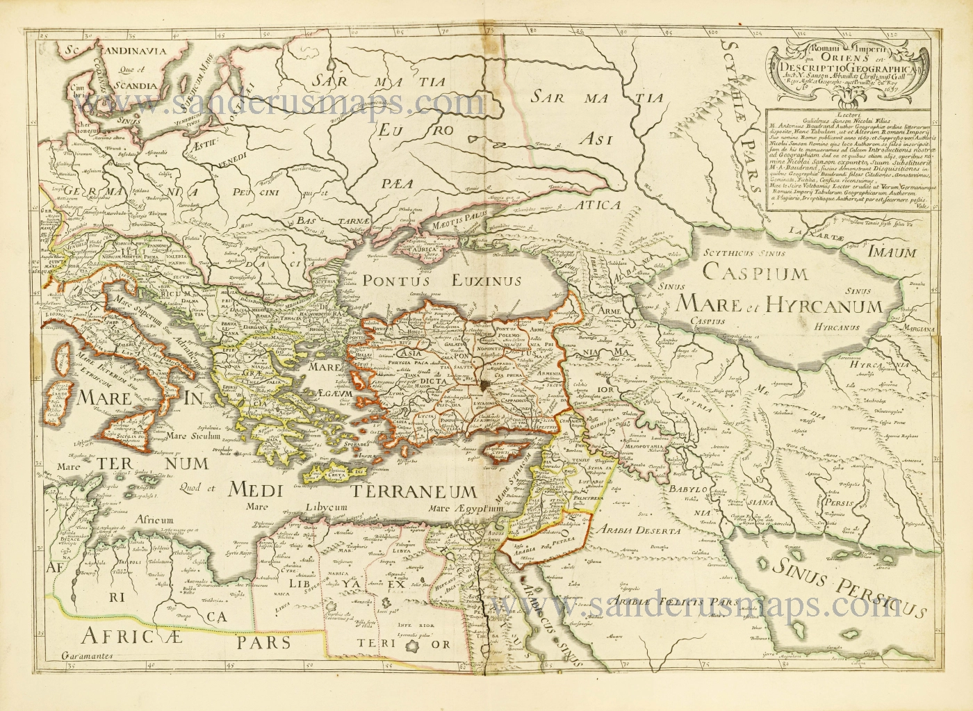
Above right below the cartouche is a note from Guillaume Sanson in which he accuses Antonius Baudrand of plagiarism.
SANSON FAMILY
Nicolas Sanson (1600-1667) - Guillaume Sanson (1633-1703) - Pierre Moullart-Sanson (? -1730)
Originally from Abbeville, Nicolas I Sanson showed a keen interest in historical geography. He was still very young; he published a map of ancient Gaul and two treatises, Britannia and Portus Itius on Abbeville and Boulogne's origins. His meeting with Melchior Tavernier was decisive: it prompted him to give up his duties as a military engineer in Picardy and devote himself to engraved cartography.
At the same time, Sanson had drawn up the outline of modern France. He got the help of Tavernier, who encouraged him to compete with the Dutch map publishers. Tavernier contacted other French cartographers whose works he published.
From 1643, N. Sanson obtained a privilege to publish a work personally, the Princes souverains de l'Italie. Then, in 1644 and 1645, he had his famous geographical tables printed, which significantly contributed to his fame. He also published a series of atlases in quarto of the four continents.
In 1648, N. Sanson associated himself with Mariette to publish atlases. From then on, specific maps bore his name and others Mariette's. N. Sanson and Mariette worked together for more than 20 years. After the death of N. Sanson, Mariette acquired the entire fund. Since Mariette only wanted to publish complete atlases, individual maps were no longer sold, and some army generals complained to the king.
The disagreement between the Sanson family and Pierre II Mariette culminated in 1671 when Guillaume Sanson took the case to court. There was no longer any question of collaboration: Guillaume Sanson started working for another publisher, Alexis-Hubert Jaillot.
The Sanson family faced financial difficulties, and in 1692, their cousin, Pierre Moullart-Sanson, bought the entire geographic fund from his uncles and aunt. Pierre Moullart-Sanson was the son of Françoise Sanson (third child of Nicolas) and Pierre Moullart. He restarted the publishing of Sanson's world atlas, and in 1704 he acquired a privilege for publishing all the works of Nicolas and Guillaume Sanson, which continued to be published until 1730.
Romani Imperii qua Oriens est Descriptio Geographica.
Item Number: 28527 Authenticity Guarantee
Category: Antique maps > Asia > Middle East
Old, antique map of Eastern Roman Empire, by Nicolas & Guillaume Sanson.
Title: Romani Imperii qua Oriens est Descriptio Geographica.
Auct[ore] N. Sanson Abbavilla[e]o Christianiss[imi] Gall[ia]ram regis math[ematic]o et geographo.
avec Privilege du Roy A[nn]o 1637.
Date: c. 1700.
Date on map: 1637.
Copper engraving, printed on paper.
Map size: 400 x 463mm (15.75 x 18.23 inches).
Sheet size: 445 x 605mm (17.52 x 23.82 inches).
Verso: Blank.
Condition: Original coloured in outline, backed with paper, excellent.
Condition Rating: A.
References: Pastoureau, Sanson V A p. 407 (103); Not in Bifolco, Mare Nostrum
From: Composite Sanson Atlas. Paris, 1700-1710.
Above right below the cartouche is a note from Guillaume Sanson in which he accuses Antonius Baudrand of plagiarism.
SANSON FAMILY
Nicolas Sanson (1600-1667) - Guillaume Sanson (1633-1703) - Pierre Moullart-Sanson (? -1730)
Originally from Abbeville, Nicolas I Sanson showed a keen interest in historical geography. He was still very young; he published a map of ancient Gaul and two treatises, Britannia and Portus Itius on Abbeville and Boulogne's origins. His meeting with Melchior Tavernier was decisive: it prompted him to give up his duties as a military engineer in Picardy and devote himself to engraved cartography.
At the same time, Sanson had drawn up the outline of modern France. He got the help of Tavernier, who encouraged him to compete with the Dutch map publishers. Tavernier contacted other French cartographers whose works he published.
From 1643, N. Sanson obtained a privilege to publish a work personally, the Princes souverains de l'Italie. Then, in 1644 and 1645, he had his famous geographical tables printed, which significantly contributed to his fame. He also published a series of atlases in quarto of the four continents.
In 1648, N. Sanson associated himself with Mariette to publish atlases. From then on, specific maps bore his name and others Mariette's. N. Sanson and Mariette worked together for more than 20 years. After the death of N. Sanson, Mariette acquired the entire fund. Since Mariette only wanted to publish complete atlases, individual maps were no longer sold, and some army generals complained to the king.
The disagreement between the Sanson family and Pierre II Mariette culminated in 1671 when Guillaume Sanson took the case to court. There was no longer any question of collaboration: Guillaume Sanson started working for another publisher, Alexis-Hubert Jaillot.
The Sanson family faced financial difficulties, and in 1692, their cousin, Pierre Moullart-Sanson, bought the entire geographic fund from his uncles and aunt. Pierre Moullart-Sanson was the son of Françoise Sanson (third child of Nicolas) and Pierre Moullart. He restarted the publishing of Sanson's world atlas, and in 1704 he acquired a privilege for publishing all the works of Nicolas and Guillaume Sanson, which continued to be published until 1730.
Related items
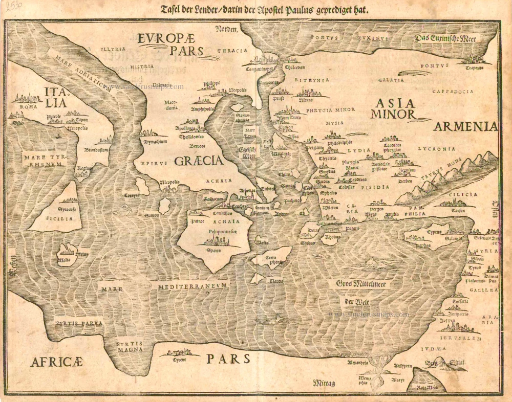
Tafel der Lender darin der Apostel Paulus geprediget hat. 1581
Eastern part of the Mediterranean Sea, by Heinrich Bünting.
[Item number: 2530]
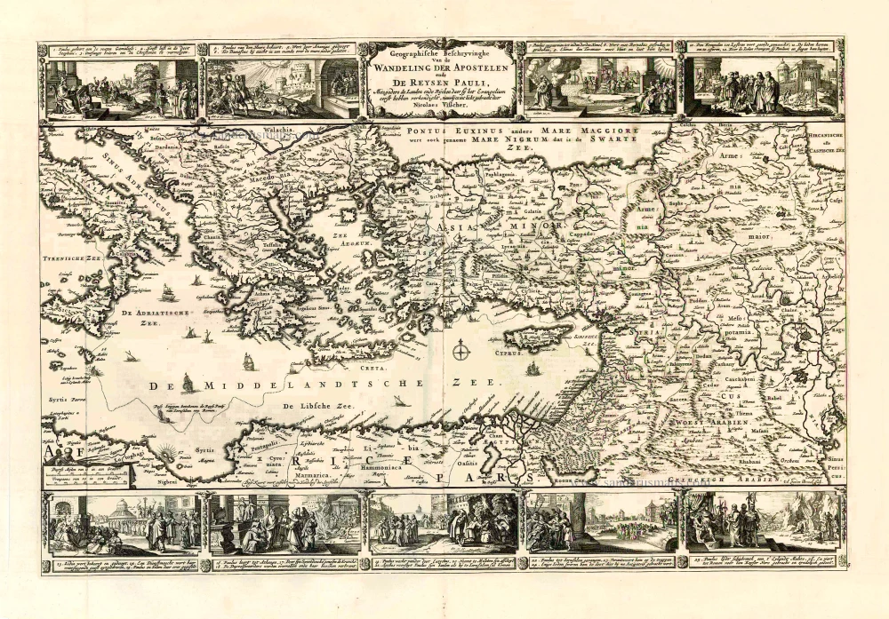
Geografische Beschryvinghe van de Wandeling der Apostelen ende De Reysen Pauli, Mitsgaders de Landen ende Rijcken daer sij het Evangelium eerst hebben verkondight. ... c. 1664
Eastern Mediterranean Sea, by Nicolaes Visscher I.
[Item number: 27590]
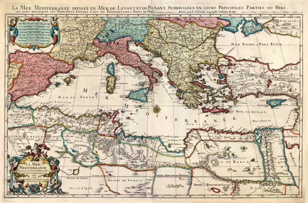
La Mer Mediterranee Divisee en ses Principales Parties ou Mers. c. 1705
Mediterranean Sea by Pieter (Pierre) Mortier
[Item number: 27767]
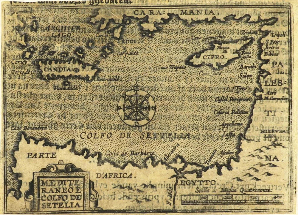
Mediteraneo e Colfo de Setelia. c. 1604
Eastern Mediterranean Sea by Jean Zuallart.
[Item number: 28484]
Parergon map
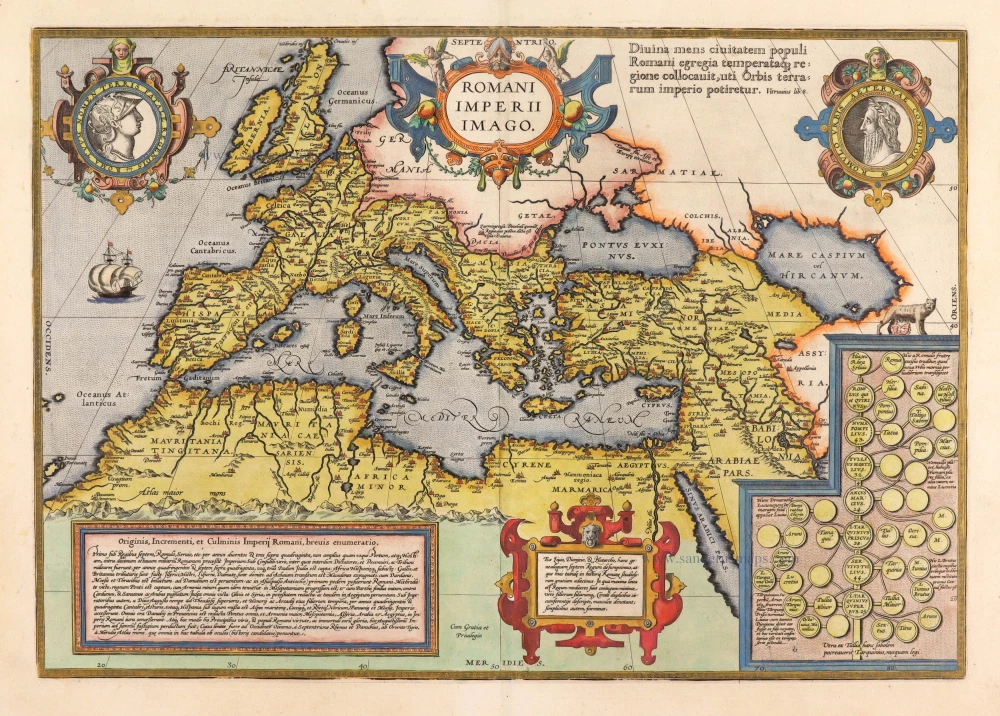
Romani Imperii Imago. 1595
Roman Empire by Abraham Ortelius.
[Item number: 30641]
Scarce first edition.
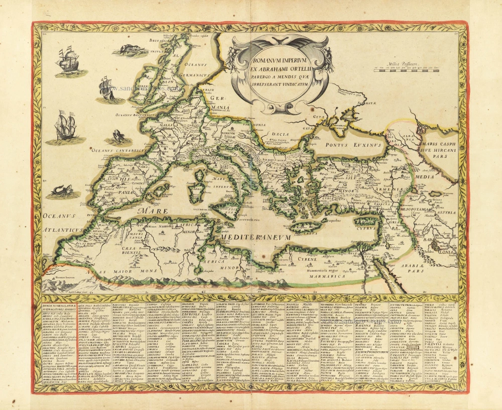
Romanum Imperium ex Abrahami Ortelii parergo a mendis quae irrepserant vindicatum. c. 1630-1650
Roman Empire by Henri Le Roy, after A. Ortelius.
[Item number: 30853]