
Rare and important chart
Java by Gerard Van Keulen. 1728
This exceptional and richly decorated chart of the Java Archipelago covers Java and the surrounding islands, from the extremities of Sumatra to Bali, featuring ten decorated compass roses, rhumb lines, and a decorative armorial dedication cartouche.
The House of Van Keulen
For more than two centuries, the chart makers firm of Van Keulen was established in the house with the name of “De Gekroonde Lootsman” (The Crowned Pilot). In 1678, the founder of the firm, Johannes I Van Keulen (1634-1689), registered with the Amsterdam booksellers’ guild. He had enlisted the aid of the well-known Mathematical Practitioner Claas Janz Vooght in the preparation of his nautical publications. In 1680 he published the first edition of the Zee-Atlas with 40 charts, all issued for the first time. In the short period of four years, they produced the five volumes of the Nieuwe Groote Ligtende Zee-Fakkel (1681-85). His acquisition of the stock of the bookseller Hendrik Doncker was an essential factor in the development of the firm.
In 1678 a son, Gerard Van Keulen (1678-1726), was born out of Johannes’s first marriage. This son was endowed with talent. He was a skilful engraver and proficient in mathematics and navigational science. Gerard was responsible for establishing the scientific basis of the firm of Van Keulen. In 1714 he was appointed to the office of hydrographer to the Dutch East India Company. The Van Keulens remained chart makers to the East India Company until the Company’s liquidation.
With the introductions to the Zee-Fakkel and Zee-Atlas, Gerard van Keulen gave a new impetus to the firm. Unfortunately, he did not live long, dying when he was 49. The business was carried on by his widow Ludwina Konst. Shortly before Gerard’s death, his son Johannes II had entered the bookseller’s guild, and in 1726 he assumed the management of the firm, though his mother retained her financial interests in the business.
Johannes II Van Keulen (1704-1755) is known in particular for his publication in 1753 of a sixth volume of the Zee-Fakkel, the volume containing the charts of the route to the East Indies.
Johannes II had two sons; they joined the firm as partners in 1757. A considerable number of books appeared in the period 1778-1801. New issues of the Zee-Fakkel again saw the light. The firm flourished under different names until 1885.
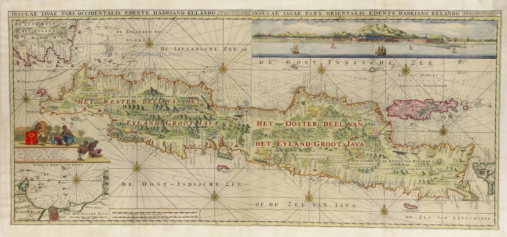
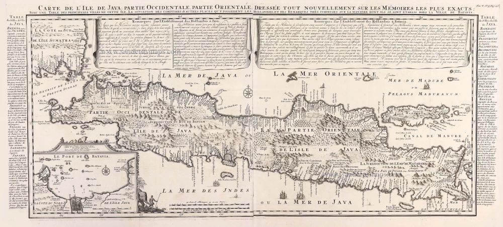
Insulae Iavae Pars Occidentalis edente Hadriano Relando. - Insulae Iavae Pars Orientalis edente Hadriano Relando.
Item Number: 32293 Authenticity Guarantee
Category: Antique maps > Asia > Southeast Asia
Java (West & East) by Gerard Van Keulen.
Title: Insulae Iavae Pars Occidentalis edente Hadriano Relando. - Insulae Iavae Pars Orientalis edente Hadriano Relando.
t Amsterdam by Gerard van Keulen aan de Nieuwe brug met Privilegie.
J. Keyser fecit.
Cartographer: Hadrian Reland.
Engraver: Jacob Keizer.
Date of the first edition: 1728.
Date of this map: 1728.
Copper engraving, printed on paper.
Image size: 510 x 1150mm (20 x 45¼ inches).
Sheet size: 565 x 1200mm (22¼ x 47¼ inches).
Verso: Blank.
Condition: Hand-coloured, margins and folds professionally reinforced at the back, good copy.
Condition Rating: A.
From: De Nieuwe Groote Ligtende Zee-Fakkel, 't Vijfde Deel. ... Amsterdam, Gerard & Ioannes van Keulen, 1728. (Koeman, Keu 124E)
Inset upper left corner: De Have of Reede van Batavia, 15 x 22,5 cm.
Inset upper right corner: Afteekening van de stad en t Kasteel van Batavia vertoonende aldus als men voor t Kasteel ter Reede Legt. 9 x 57 cm.
First and only edition of this scarce map. According to Koeman, this map appeared only in the fifth part of the Zee-Fakkel, 1728.
This is one of the twelve new charts that appeared in the 1728 edition of the Fifth part of the Zee-Fakkel, first published in 1683.
This exceptional and richly decorated chart of the Java Archipelago covers Java and the surrounding islands, from the extremities of Sumatra to Bali, featuring ten decorated compass roses, rhumb lines, and a decorative armorial dedication cartouche.
The House of Van Keulen
For more than two centuries, the chart makers firm of Van Keulen was established in the house with the name of “De Gekroonde Lootsman” (The Crowned Pilot). In 1678, the founder of the firm, Johannes I Van Keulen (1634-1689), registered with the Amsterdam booksellers’ guild. He had enlisted the aid of the well-known Mathematical Practitioner Claas Janz Vooght in the preparation of his nautical publications. In 1680 he published the first edition of the Zee-Atlas with 40 charts, all issued for the first time. In the short period of four years, they produced the five volumes of the Nieuwe Groote Ligtende Zee-Fakkel (1681-85). His acquisition of the stock of the bookseller Hendrik Doncker was an essential factor in the development of the firm.
In 1678 a son, Gerard Van Keulen (1678-1726), was born out of Johannes’s first marriage. This son was endowed with talent. He was a skilful engraver and proficient in mathematics and navigational science. Gerard was responsible for establishing the scientific basis of the firm of Van Keulen. In 1714 he was appointed to the office of hydrographer to the Dutch East India Company. The Van Keulens remained chart makers to the East India Company until the Company’s liquidation.
With the introductions to the Zee-Fakkel and Zee-Atlas, Gerard van Keulen gave a new impetus to the firm. Unfortunately, he did not live long, dying when he was 49. The business was carried on by his widow Ludwina Konst. Shortly before Gerard’s death, his son Johannes II had entered the bookseller’s guild, and in 1726 he assumed the management of the firm, though his mother retained her financial interests in the business.
Johannes II Van Keulen (1704-1755) is known in particular for his publication in 1753 of a sixth volume of the Zee-Fakkel, the volume containing the charts of the route to the East Indies.
Johannes II had two sons; they joined the firm as partners in 1757. A considerable number of books appeared in the period 1778-1801. New issues of the Zee-Fakkel again saw the light. The firm flourished under different names until 1885.
Related items
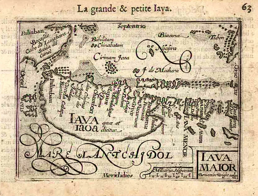
Iava Maior. 1618
Java, by Bertius P.
[Item number: 18307]
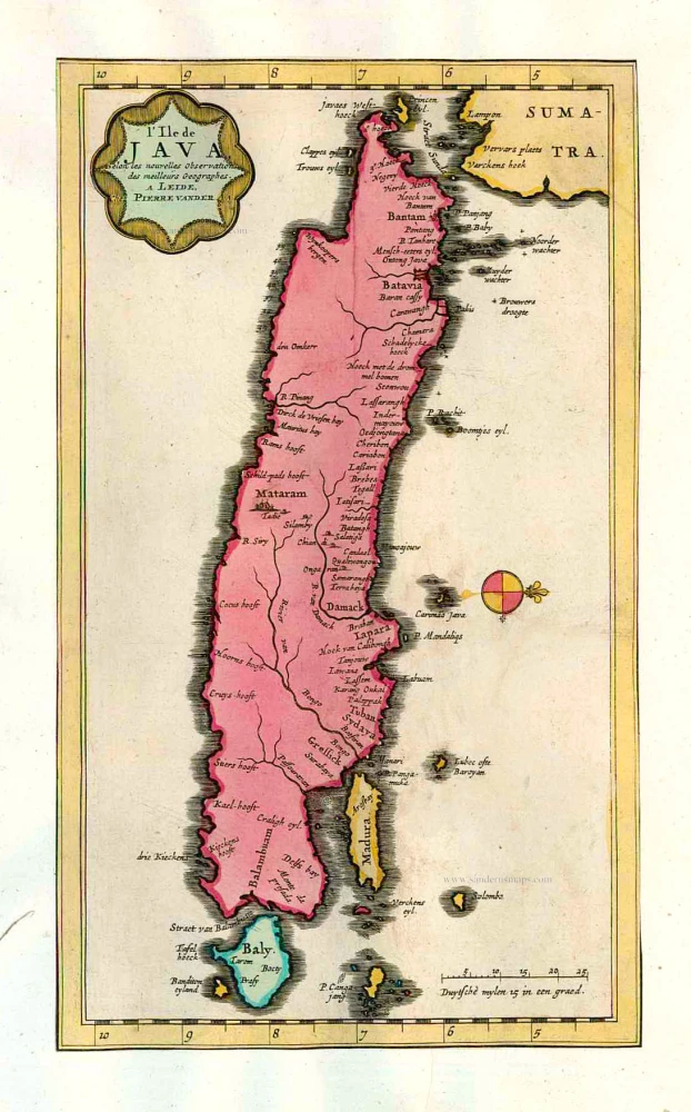
L'Ile de Java. 1713
Java, by Pieter van der Aa.
[Item number: 26127]
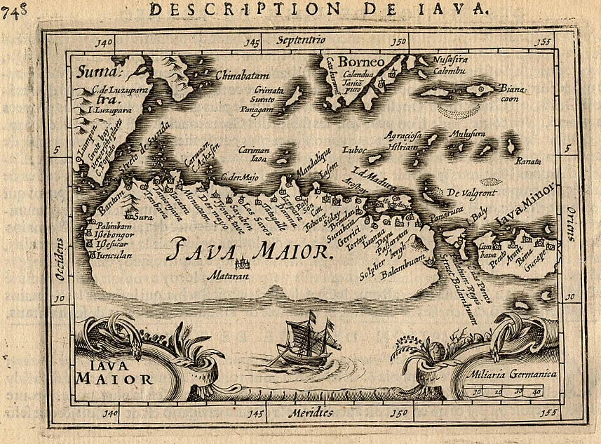
Iava Maior. c. 1600
Java by Barent Langenes & Cornelis Claesz
[Item number: 26935]

Big and important map.
Nieuwe en zeer naaukeurige kaart van t Eyland Java Major of Groot Java. 1724-26
Java, by François Valentyn (Valentijn).
[Item number: 27054]
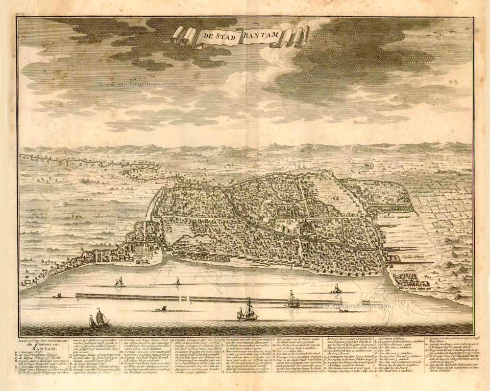
De Stad Bantam. 1724
Bantam (Java), by François Valentyn (Valentijn).
[Item number: 27939]
Carte de L'Ile de Java: Partie Occidentale, Partie Orientale, Dressée tout nouvellement sur les mémoires les plus exacts. 1719
Java, by Z. Châtelain.
[Item number: 29377]
Rare and important chart
Insulae Iavae Pars Occidentalis edente Hadriano Relando. - Insulae Iavae Pars Orientalis edente Hadriano Relando. 1728
Java by Gerard Van Keulen.
[Item number: 32293]

't Koninkryk Sunda met dat van Iava, by d'Inwoonderen voor een eiland gehouden, en door den Hr. I.B. de Lavanha als twee Eylanden Beschreven. 1707
Indonesia - Java and the Sunda Strait, by Pieter Van der Aa.
[Item number: 32360]

Het Eiland Java zoo als het sederd de tyden der Portugysen by de Ed. Oost-Indize maatschappye bekend geworden en bevaren is. 1707
Indonesia - Java and the Sunda Strait, by Pieter Van der Aa.
[Item number: 32361]