
Old antique map of Southeast Asia, by Abraham Ortelius 1572

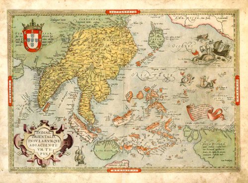

"This map represents a synthesis of the best readily available information on Southeast Asia and the East Indian Islands from Italian, Portuguese and Spanish sources. The map extends from Portuguese India in the west, through China, Japan, Southeast Asia and the East Indies (Indonesian archipelago), including New Guinea, to the Northwest coast of America. Sumatra and Java are shown heavily distorted in shape together with the principal spice islands, but the emergent shape of Borneo and the Philippines is apparent as well as the general configuration of the East Indian archipelago. Java is shown as an island but with a greatly inflated shape and no topographical information along the south coast, separated from Beach, a presumed promontory on the southern or 'fifth' continent. Borneo is mapped in the place of the fictitious 'Java Minor' that frequently appeared at that latitude on the 'modern' Ptolemaic maps of the region, although only the part of Borneo north of the equator is shown to the west of a barely recognizable Celebes (Sulawesi), where no hint is given of the very distinctive peninsula geography of the island. On the other hand, the clove-producing islands of Ternate, Tidore and their neighbours to the south, Machian and Bacam, are correctly located to the west of the easily identifiable island of Gilolo (Halmahera) with its four distinctive peninsulas. Buru island is located correctly to the west of the main Ambon island, now called Seram, and although the 'Bird's Head' part of New Guinea (Irian Jaya) is shown as three islands, the outline of the coasts, particularly the north coast, strongly suggests that Ortelius based his information on actual charts of the coasts. Gebe island, where the French obtained the first clove and nutmeg seedlings they smuggled out in the eighteenth century and which currently contains one of Indonesia's largest nickel mines, is correctly located on the equator between Gilolo and New Guinea. The map 'Indiae Orientalis Insularumque Adiacentium Typus' by Ortelius is a 'milestone' map in the cartography of Southeast Asia and the East Indian Islands. It represents the synthesis of cartographic knowledge of the region for the first seventy years of the sixteenth century and, most importantly, brought that knowledge to a very wide audience through the numerous editions of the Theatrum. The map must be considered one of the gems of any private collection of maps of the region and, somewhat surprisingly, is still available for collectors at a reasonable price." (Parry, p.76-78)
Abraham Ortelius (1527-1598)
The maker of the 'first atlas', the Theatrum Orbis Terrarum (1570), was born on 4 April 1527 into an old Antwerp family. He learned Latin and studied Greek and mathematics.
Abraham and his sisters, Anne and Elizabeth, took up map colouring. Ortelius was admitted to the Guild of St. Luke as an "illuminator of maps." In addition to colouring maps, Ortelius was a dealer in antiques, coins, maps, and books, and the book and map trade gradually became his primary occupation.
Business went well because his means allowed him to amass an extensive collection of medals, coins, and antiques, as well as a library of many volumes. In addition, he travelled extensively, visited Italy and France, made contacts with scholars and editors everywhere, and maintained extensive correspondence with them.
In 1564, he published his first map, a large and ambitious world wall map. The inspiration for this map may well have been Gastaldi's large world map. In 1565, he published a map of Egypt and a map of the Holy Land; a large map of Asia followed.
In 1568, the production of individual maps for his atlas Theatrum Orbis Terrarum was already in full swing. He completed the atlas in 1569, and in May 1570, it was available for sale. It was one of the most expensive books ever published.
This first edition contained seventy maps on fifty-three sheets. Franciscus Hogenberg engraved the maps.
Later editions included Additamenta (additions), resulting in Ortelius' historical atlas, the Parergon, which is mainly bound together with the atlas. The Parergon can be considered a truly original work by Ortelius, who drew the maps based on his research.
The importance of the Theatrum Orbis Terrarum for geographical knowledge in the last quarter of the sixteenth century is difficult to overemphasise. Nothing was like it until Mercator's atlas appeared twenty-five years later. Demand for the Theatrum was remarkable. Some 24 editions appeared during Ortelius's lifetime, and another 10 after he died in 1598. Editions were published in Dutch, German, French, Spanish, English, and Italian. The number of map sheets grew from 53 in 1570 to 167 in the last edition in 1612.
In 1577, engraver Philip Galle and poet-translator Pieter Heyns published the first pocket-sized edition of the Theatrum, the Epitome. The work was trendy. Over thirty editions of this Epitome were published in different languages.
Ortelius is also remembered for an early idea resembling continental drift: he suggested that the Americas, Europe, and Africa may once have been joined together before separating over time. His work helped shape the development of modern geography and mapmaking.
Indiae Orientalis Insularumque Adiacientium Typus.
Item Number: 16795 Authenticity Guarantee
Category: Antique maps > Asia > Southeast Asia
Old, antique map of Southeast Asia by A. Ortelius.
Date of the first edition: 1570
Date of this map: 1572
Copper engraving
Size: 35 x 50cm (13.7 x 19.5 inches)
Verso text: German
Condition: Contemporary old-coloured, some thumb-soiling at lower margin.
Condition Rating: A
References: Van der Krogt 3, 8400:31; Van den Broecke, 166; Karrow, 1/68; Durant-Curtis, #11; Clancy, p.71 Map 5.16.
From: Theatrum oder Schawplatz des Erdbodems. Antwerpen, Gielis Coppens van Diest, 1572. (Van der Krogt, 3, 201)
"This map represents a synthesis of the best readily available information on Southeast Asia and the East Indian Islands from Italian, Portuguese and Spanish sources. The map extends from Portuguese India in the west, through China, Japan, Southeast Asia and the East Indies (Indonesian archipelago), including New Guinea, to the Northwest coast of America. Sumatra and Java are shown heavily distorted in shape together with the principal spice islands, but the emergent shape of Borneo and the Philippines is apparent as well as the general configuration of the East Indian archipelago. Java is shown as an island but with a greatly inflated shape and no topographical information along the south coast, separated from Beach, a presumed promontory on the southern or 'fifth' continent. Borneo is mapped in the place of the fictitious 'Java Minor' that frequently appeared at that latitude on the 'modern' Ptolemaic maps of the region, although only the part of Borneo north of the equator is shown to the west of a barely recognizable Celebes (Sulawesi), where no hint is given of the very distinctive peninsula geography of the island. On the other hand, the clove-producing islands of Ternate, Tidore and their neighbours to the south, Machian and Bacam, are correctly located to the west of the easily identifiable island of Gilolo (Halmahera) with its four distinctive peninsulas. Buru island is located correctly to the west of the main Ambon island, now called Seram, and although the 'Bird's Head' part of New Guinea (Irian Jaya) is shown as three islands, the outline of the coasts, particularly the north coast, strongly suggests that Ortelius based his information on actual charts of the coasts. Gebe island, where the French obtained the first clove and nutmeg seedlings they smuggled out in the eighteenth century and which currently contains one of Indonesia's largest nickel mines, is correctly located on the equator between Gilolo and New Guinea. The map 'Indiae Orientalis Insularumque Adiacentium Typus' by Ortelius is a 'milestone' map in the cartography of Southeast Asia and the East Indian Islands. It represents the synthesis of cartographic knowledge of the region for the first seventy years of the sixteenth century and, most importantly, brought that knowledge to a very wide audience through the numerous editions of the Theatrum. The map must be considered one of the gems of any private collection of maps of the region and, somewhat surprisingly, is still available for collectors at a reasonable price." (Parry, p.76-78)
Abraham Ortelius (1527-1598)
The maker of the 'first atlas', the Theatrum Orbis Terrarum (1570), was born on 4 April 1527 into an old Antwerp family. He learned Latin and studied Greek and mathematics.
Abraham and his sisters, Anne and Elizabeth, took up map colouring. Ortelius was admitted to the Guild of St. Luke as an "illuminator of maps." In addition to colouring maps, Ortelius was a dealer in antiques, coins, maps, and books, and the book and map trade gradually became his primary occupation.
Business went well because his means allowed him to amass an extensive collection of medals, coins, and antiques, as well as a library of many volumes. In addition, he travelled extensively, visited Italy and France, made contacts with scholars and editors everywhere, and maintained extensive correspondence with them.
In 1564, he published his first map, a large and ambitious world wall map. The inspiration for this map may well have been Gastaldi's large world map. In 1565, he published a map of Egypt and a map of the Holy Land; a large map of Asia followed.
In 1568, the production of individual maps for his atlas Theatrum Orbis Terrarum was already in full swing. He completed the atlas in 1569, and in May 1570, it was available for sale. It was one of the most expensive books ever published.
This first edition contained seventy maps on fifty-three sheets. Franciscus Hogenberg engraved the maps.
Later editions included Additamenta (additions), resulting in Ortelius' historical atlas, the Parergon, which is mainly bound together with the atlas. The Parergon can be considered a truly original work by Ortelius, who drew the maps based on his research.
The importance of the Theatrum Orbis Terrarum for geographical knowledge in the last quarter of the sixteenth century is difficult to overemphasise. Nothing was like it until Mercator's atlas appeared twenty-five years later. Demand for the Theatrum was remarkable. Some 24 editions appeared during Ortelius's lifetime, and another 10 after he died in 1598. Editions were published in Dutch, German, French, Spanish, English, and Italian. The number of map sheets grew from 53 in 1570 to 167 in the last edition in 1612.
In 1577, engraver Philip Galle and poet-translator Pieter Heyns published the first pocket-sized edition of the Theatrum, the Epitome. The work was trendy. Over thirty editions of this Epitome were published in different languages.
Ortelius is also remembered for an early idea resembling continental drift: he suggested that the Americas, Europe, and Africa may once have been joined together before separating over time. His work helped shape the development of modern geography and mapmaking.
Related items

Archipel des Indes Orientales qui Comprend les Isles de la Sonde, Moluques et Philippines. c. 1757
Southeast Asia, par Robert de Vaugondy.
[Item number: 4751]

The most accurate and one of the most elegant 17th c. maps of the East Indies
Indiae Orientalis Nova Descriptio. 1644-58
Southeast Asia by Janssonius, Johannes
[Item number: 10013]

Accuratissima totius Asiae Tabula. c. 1691-96
Asia, by F. De Wit.
[Item number: 10960]

Exactissima Asiae Delineatio in praecipuas regiones Caeterasq Partes divisa. 1696-1713
Asia by Th. Danckerts.
[Item number: 11298]

Asia qua Nulla Beatior Ora; Tractus in Eoos Vergens Mundique Teporem. c. 1730.
Asia, by G.& L. Valk.
[Item number: 24538]

Le Royaume de Siam avec les Royaumes qui luy sont Tributaires, et les Isles de Sumatra, Andemaon, etc. et les Isles Voisine. c. 1700
Southeast Asia, by J. Ottens.
[Item number: 25716]

An extremely decorative sea chart (Norwhich)
Nieuwe Pascaert van Oost Indien Verthoonende hen van C. De Bona Esperanca tot aen het Landt van Eso. 1683
Indian Ocean - Southeast Asia - Australia by Johannes Van Keulen
[Item number: 33150]
new