
The Moluccas by Vincenzo Coronelli. 1696


Vincenzo Coronelli (1650-1718)
Vincenzo Coronelli was born in Venice on 16 August 1650 and primarily brought up in Ravenna. He returned to Venice in 1665 and joined the convent of the Minor Conventuals. Five years later, he was sent to Rome to study, and by 1673, he was already a doctor of theology.
Having achieved fame by constructing two globes for the Duke of Parma, he was invited to Paris for three years in 1681 and made two enormous examples for Louis XIV. On his return to Venice, he assiduously collected cartographic material and founded the Academy of the Argonauts. In 1685, he was appointed Cosmographer to the Republic of Venice and authorised to publish a large atlas. He became a geography lecturer at the University of Venice and brought out an Atlante Veneto the following year.
In 1696, he visited Germany, Holland and southern England. During intervals in compiling his vast encyclopaedia, he continued with cartographic projects up to 1709. He died in his native Venice on 9 December 1718.
Coronelli became famous for his globes. In addition, he was a renowned encyclopaedist, mapmaker and geographer. Most of his maps and other material are gathered in his Atlante Veneto (13 vols, 1690-1705). The first volume, subtitled Descrizione generale istorica geografica, was his masterpiece, planned as an extension of Blaeu’s atlas.
Other volumes of the atlas which contain maps are Isolario, two parts (1696-8), with detailed maps and plans, mostly of islands; Corso geografico, two parts based on the edition 1694-7; Libro de’ globi (1697); and Lo Specchio del Mare, a reprint of Levanto's Lo Specchio del Mare Mediterraneo of 1664.
The other vital aspects of his mapping are those arising from the Venetian conquest and his travels. His most extensive military compilation was the Teatro della Guerra, in more than 30 volumes.
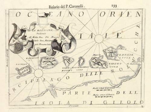
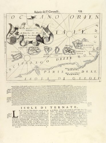
Le Molucchi.
Item Number: 28944 Authenticity Guarantee
Category: Antique maps > Asia > Southeast Asia
Old, antique map of The Moluccas by Vincenzo Coronelli.
Title: Le Molucchi.
Dedicate Al Molto Reu: Pré Maestro Carlo Tosi, Min Congia Provinciale.
Oriented to the west.
Date of the first edition: 1696.
Date of this map: 1696.
Copper engraving, printed on paper.
Map size: 225 x 310mm (8.86 x 12.2 inches).
Sheet size: 480 x 350mm (18.9 x 13.78 inches).
Verso: Italian text.
Condition: Excellent.
Condition Rating: A+
From: Isolario Descrittione Geografico-Historica, Sacro-Profano, Antico-Moderna, Politica, Naturale e Poetica ... di Tutti l'Isole ... Tomo II dell'Atlante Veneto ... del P.Maestro Vincenzo Coronelli ... A'Spese dell'Autore MDCLXXXXVI. (Shirley (Brit.Lib), T.CORO-13a)
Vincenzo Coronelli (1650-1718)
Vincenzo Coronelli was born in Venice on 16 August 1650 and primarily brought up in Ravenna. He returned to Venice in 1665 and joined the convent of the Minor Conventuals. Five years later, he was sent to Rome to study, and by 1673, he was already a doctor of theology.
Having achieved fame by constructing two globes for the Duke of Parma, he was invited to Paris for three years in 1681 and made two enormous examples for Louis XIV. On his return to Venice, he assiduously collected cartographic material and founded the Academy of the Argonauts. In 1685, he was appointed Cosmographer to the Republic of Venice and authorised to publish a large atlas. He became a geography lecturer at the University of Venice and brought out an Atlante Veneto the following year.
In 1696, he visited Germany, Holland and southern England. During intervals in compiling his vast encyclopaedia, he continued with cartographic projects up to 1709. He died in his native Venice on 9 December 1718.
Coronelli became famous for his globes. In addition, he was a renowned encyclopaedist, mapmaker and geographer. Most of his maps and other material are gathered in his Atlante Veneto (13 vols, 1690-1705). The first volume, subtitled Descrizione generale istorica geografica, was his masterpiece, planned as an extension of Blaeu’s atlas.
Other volumes of the atlas which contain maps are Isolario, two parts (1696-8), with detailed maps and plans, mostly of islands; Corso geografico, two parts based on the edition 1694-7; Libro de’ globi (1697); and Lo Specchio del Mare, a reprint of Levanto's Lo Specchio del Mare Mediterraneo of 1664.
The other vital aspects of his mapping are those arising from the Venetian conquest and his travels. His most extensive military compilation was the Teatro della Guerra, in more than 30 volumes.
Related items

Caerte vande Landen vande Papouas ofte Nova Guinea nae de beseijlinge en ondecking van Iacob le Maire gedaen in den Iare 1616. / Tabula exhibens Papouarum seu Nova Guineae Regones ... / Cartes des Terres de Papouas ou de Guinee Neuve ... 1622
Chart of the route of Schouten and Le Maire north of New Guinea, and the Moluccas, by A. de Herrera, published by M. Colijn.
[Item number: 4165]

De Landvoogdy der Moluccos, met de aangrenzende Eylanden. 1724
The Moluccas by François Valentyn (Valentijn).
[Item number: 17559]

De Landvoogdy van Amboina met de elf onderhoorige Eylanden 1724-26
Ambon (Moluccas), by François Valentyn (Valentijn).
[Item number: 17566]

De Landvoogdy van Amboina met de elf onderhoorige Eylanden 1724-26
Moluccas by François Valentyn (Valentijn)
[Item number: 17787]

Amboina. 1724-26
Ambon Island (Moluccas), by François Valentyn.
[Item number: 17791]

[No title] 1724-26
Moluccas - Buru and Ambelou, by Valentyn.
[Item number: 20926]

[No title] 1724-26
Moluccas - Buru & Ambelou, by Valentyn.
[Item number: 20928]

Spice islands
Insularum Moluccarum Nova Descriptio. 1646
Moluccas by Joannes Janssonius.
[Item number: 23718]

Les Îles Moluques. 1713
The Moluccas - Ternate and adjacent islands, by Pieter Van der Aa.
[Item number: 26124]

Moluccae Insulae. c. 1600
Moluccas by Barent Langenes & Cornelis Claesz
[Item number: 26996]

The Spice Islands
Moluccae Insulae Celeberimae. 1640
Moluccas by Willem Blaeu
[Item number: 31047]

Moluccae insulae. 1618
Moluccas, by Petrus Bertius
[Item number: 32174]

Scarce
De Moluccos, of Speceri-dragende Eilanden Tussen Gigolo en Celebes gelegen. 1707
Moluccas, by Pieter Van der Aa.
[Item number: 32346]
De Moluccos en andere Speceri-eilanden in d'Oost-Indien. 1707
Spice Islands, by Pieter Van der Aa.
[Item number: 32401]