
Rare.
Cyprus by Nicolas Sanson, published by Pierre Mariette. ca. 1658-1663

This rare map appeared when Sanson started collaborating with Pierre Mariette. Nicolas Sanson himself did not make a map of Cyprus. The map is based on Janssonius' map of 1637. Aphrodite has been eliminated and in her place is depicted a cartouche surmounted by a winged Eros.
Nicolas Sanson (1600-1667) - Guillaume Sanson (1633-1703)
Originally from Abbeville, Nicolas I Sanson showed a keen interest in historical geography. Still very young, he published a map of ancient Gaul and two treatises, Britannia and Portus Itius on Abbeville and Boulogne's origins. His meeting with Melchior Tavernier was decisive: it prompted him to give up his duties as a military engineer in Picardy and devote himself to engraved cartography.
At the same time, Sanson had drawn up the outline of modern France. He got the help of Tavernier who encouraged him to compete with the Dutch map publishers. Tavernier contacted other French cartographers whose works he published.
From 1643, N. Sanson obtained a privilege to publish a work personally, the Princes souverains de l'Italie. Then, in 1644 and 1645, he had his famous geographical tables printed, which significantly contributed to his fame. He also published a series of atlases in quarto of the four continents.
In 1648, N. Sanson associated himself with Mariette for the publishing of atlases. From then on, certain maps bore his name, and others Mariette's. N. Sanson and Mariette worked together for more than 20 years. After the death of N. Sanson, Mariette acquired the entire fund. Since Mariette only wanted to publish complete atlases, individual maps were no longer sold, and some army generals complained to the king.
The disagreement between the Sanson family and Pierre II Mariette culminated in 1671 when Guillaume Sanson took the case to court. From then on, there was no longer any question of collaboration: Guillaume Sanson started working for another publisher, Alexis-Hubert Jaillot.
The Sanson family faced financial difficulties, and in 1692, their cousin, Pierre Moullart-Sanson, bought the entire geographic fund from his uncles and aunt. Moullart-Sanson restarted the publishing of Sanson's world atlas, and in 1704 he acquired a privilege for publishing all the works of Nicolas and Guillaume Sanson, which continued to be published until 1730.
Pierre Mariette (1602-1658)
Bookseller, printseller, printer, and publisher, located in the Rue Saint-Jacques in Paris. On February 12, 1644, Pierre Mariette acquired most of Melchior Tavernier's fund. In 1646, he had a series of maps by Blaeu copied and asked Abraham Peyrounin to engrave them. In the meantime, he published the works of Nicolas Sanson. In 1650, he published the atlas Théâtre Géographique de France. A second edition followed in 1653. He later contributed to Sanson's atlas, the Cartes générales de toutes les parties du monde. Many maps of Mariette's Théatre appeared in later editions of Sanson's Cartes générales.
Cyprus Insula.
Item Number: 30045 Authenticity Guarantee
Category: Antique maps > Asia > Turkey - Cyprus
Old, antique map of Turkey by Nicolas Sanson, published by Pierre Mariette.
Title: Cyprus Insula.
Lutetiae Parisiorum apud petrum Mariette, via Iacobea sub Insigni Spei.
I. Somer Sculp.
Engraver: Jean Somer.
Date: ca. 1658-1663.
Copper engraving, printed on paper.
Image size: 375 x 485mm (14.76 x 19.09 inches).
Sheet size: 490 x 640mm (19.29 x 25.2 inches).
Verso: Blank.
Condition: Original coloured in outline, excellent.
Condition Rating: A+.
Separate publication.
This rare map appeared when Sanson started collaborating with Pierre Mariette. Nicolas Sanson himself did not make a map of Cyprus. The map is based on Janssonius' map of 1637. Aphrodite has been eliminated and in her place is depicted a cartouche surmounted by a winged Eros.
Nicolas Sanson (1600-1667) - Guillaume Sanson (1633-1703)
Originally from Abbeville, Nicolas I Sanson showed a keen interest in historical geography. Still very young, he published a map of ancient Gaul and two treatises, Britannia and Portus Itius on Abbeville and Boulogne's origins. His meeting with Melchior Tavernier was decisive: it prompted him to give up his duties as a military engineer in Picardy and devote himself to engraved cartography.
At the same time, Sanson had drawn up the outline of modern France. He got the help of Tavernier who encouraged him to compete with the Dutch map publishers. Tavernier contacted other French cartographers whose works he published.
From 1643, N. Sanson obtained a privilege to publish a work personally, the Princes souverains de l'Italie. Then, in 1644 and 1645, he had his famous geographical tables printed, which significantly contributed to his fame. He also published a series of atlases in quarto of the four continents.
In 1648, N. Sanson associated himself with Mariette for the publishing of atlases. From then on, certain maps bore his name, and others Mariette's. N. Sanson and Mariette worked together for more than 20 years. After the death of N. Sanson, Mariette acquired the entire fund. Since Mariette only wanted to publish complete atlases, individual maps were no longer sold, and some army generals complained to the king.
The disagreement between the Sanson family and Pierre II Mariette culminated in 1671 when Guillaume Sanson took the case to court. From then on, there was no longer any question of collaboration: Guillaume Sanson started working for another publisher, Alexis-Hubert Jaillot.
The Sanson family faced financial difficulties, and in 1692, their cousin, Pierre Moullart-Sanson, bought the entire geographic fund from his uncles and aunt. Moullart-Sanson restarted the publishing of Sanson's world atlas, and in 1704 he acquired a privilege for publishing all the works of Nicolas and Guillaume Sanson, which continued to be published until 1730.
Pierre Mariette (1602-1658)
Bookseller, printseller, printer, and publisher, located in the Rue Saint-Jacques in Paris. On February 12, 1644, Pierre Mariette acquired most of Melchior Tavernier's fund. In 1646, he had a series of maps by Blaeu copied and asked Abraham Peyrounin to engrave them. In the meantime, he published the works of Nicolas Sanson. In 1650, he published the atlas Théâtre Géographique de France. A second edition followed in 1653. He later contributed to Sanson's atlas, the Cartes générales de toutes les parties du monde. Many maps of Mariette's Théatre appeared in later editions of Sanson's Cartes générales.
Related items

Parergon map
Insular. aliquot Aegaei Maris Antiqua Descrip. 1601
Cyprus & other Greek Islands by Abraham Ortelius.
[Item number: 12452]

Cyprus Insula - Candia, olim Creta. 1572
Cyprus - Crete, by A. Ortelius.
[Item number: 16585]
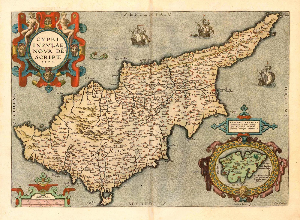
Cypri Insulae Nova Descript. 1573 1592
Cyprus, by Ortelius A.
[Item number: 22955]

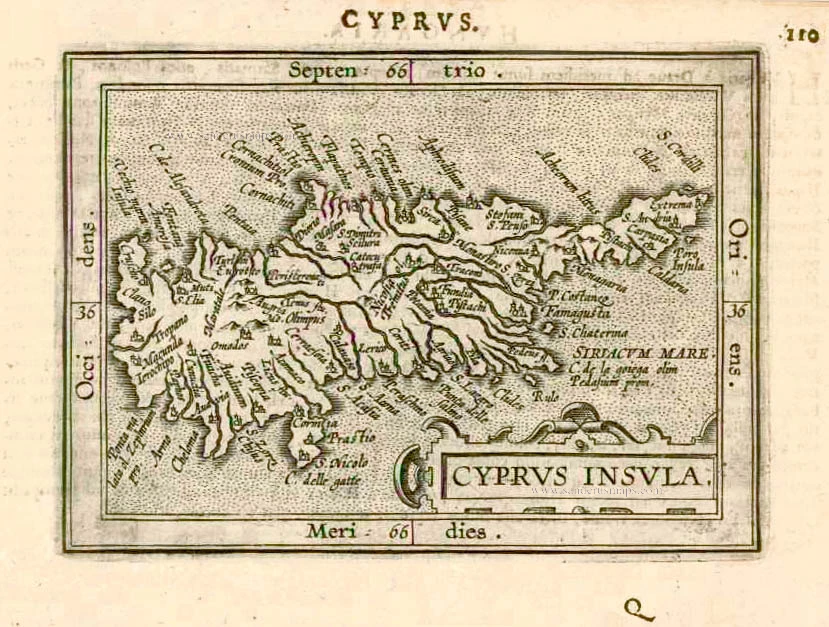
Cyprus Insula. 1552
Cyprus, by S. Münster.
[Item number: 25723]

Cyprus Ins: 1641
Cyprus, by Henricus Hondius.
[Item number: 26436]

Scarce
Cyprus Insula. - De L'Isle de Chipre. 1575
Cyprus, by François Belleforest.
[Item number: 27300]
Cyprus Insula. 1609
Cyprus by Abraham Ortelius.
[Item number: 27509]

Very rare.
Cipro insula nobiliss. ... c. 1575
Cyprus by Giovanni Francesco Camocio
[Item number: 27577]
Rare!
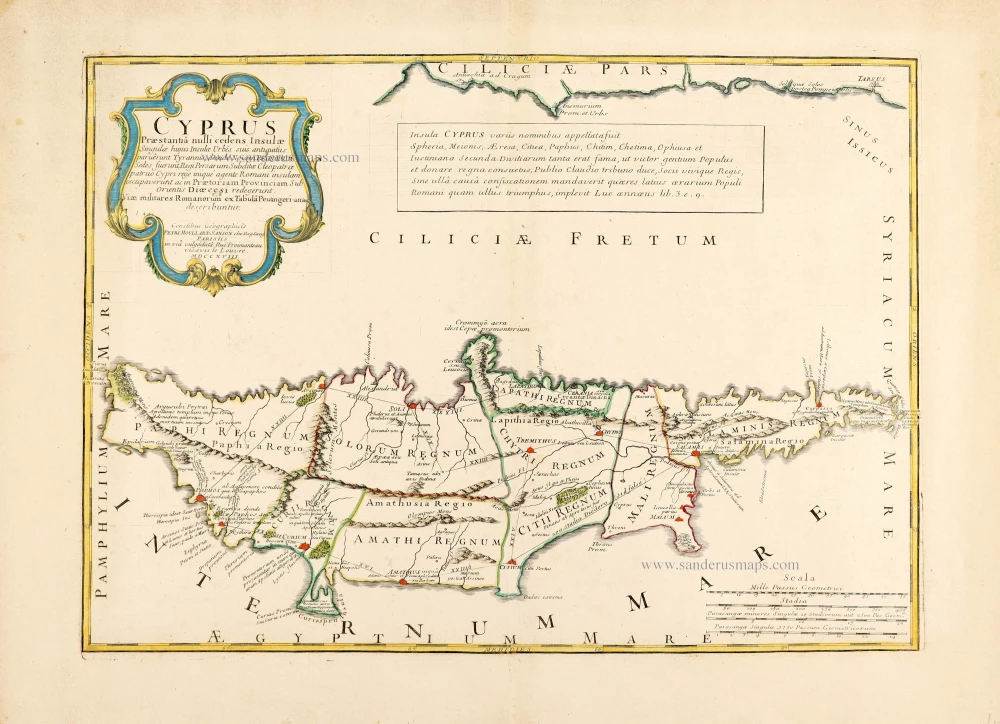
Cyprus Praestantia nulli cedens Insulae. 1718
Cyprus by Pierre Moullart-Sanson.
[Item number: 28632]

Insular. aliquot Aegaei Maris Antiqua Descrip. 1601
Cyprus & other Greek Islands, by Abraham Ortelius.
[Item number: 28639]

Acamantis Insula hoggidi Cipro, 1696
Cyprus by Vincenzo Coronelli.
[Item number: 28655]
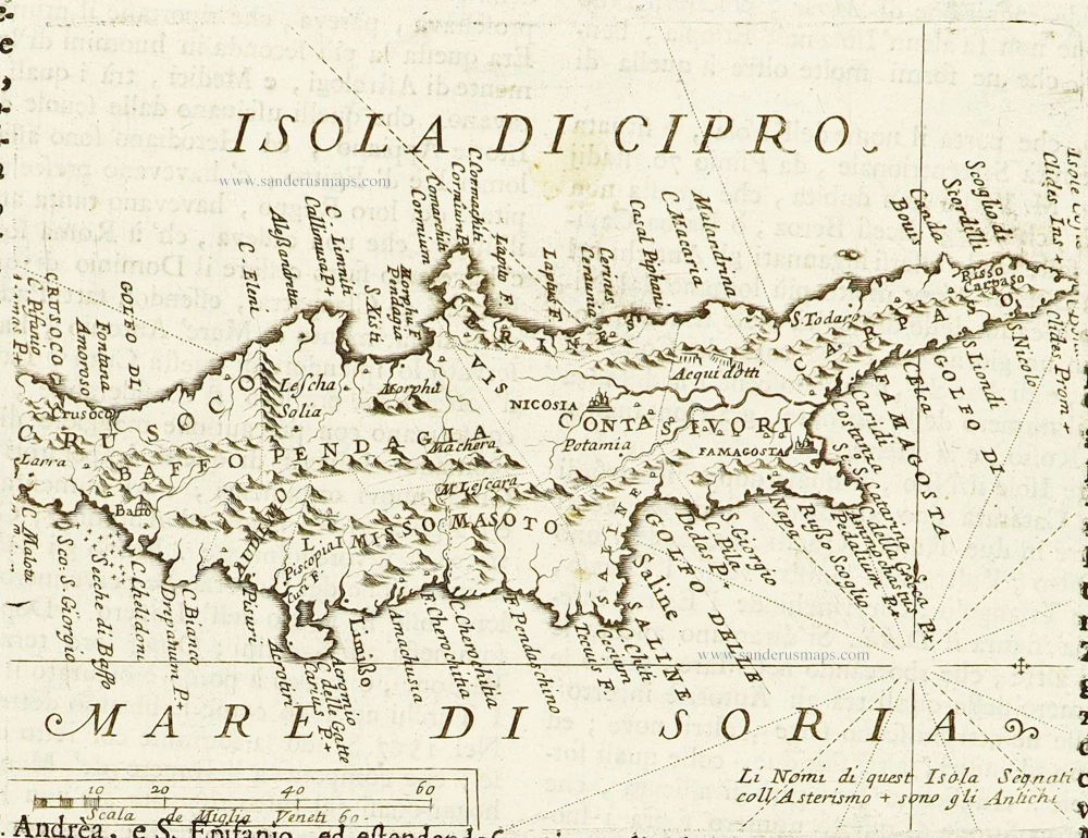
Isola di Cipro. 1696
Cyprus by Vincenzo Coronelli.
[Item number: 28667]

Cypri Insulae Nova Descript. 1573 1584
Cyprus by Abraham Ortelius.
[Item number: 29484]

Cypri Insulae Nova Descript. 1573 1575
Cyprus by Abraham Ortelius.
[Item number: 30103]

Cyprus Insula. 1640
Cyprus, by W. & J. Blaeu.
[Item number: 32828]