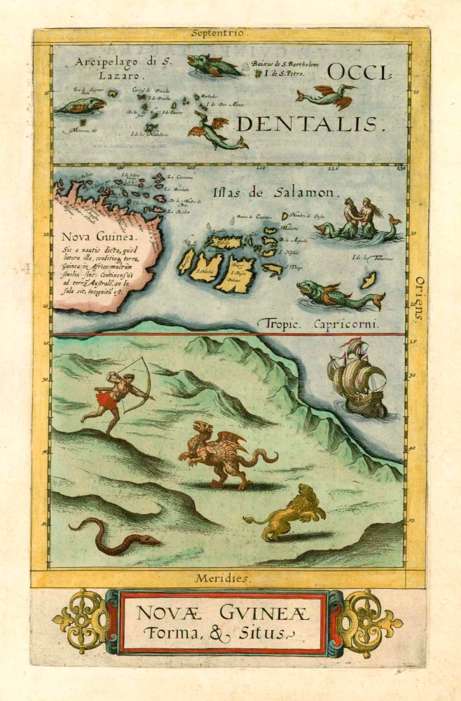
Old antique map of Australia with New Guinea and the Solomon Ilands by G. de Jode 1593
The map is beautifully adorned with mythical sea creatures and ships.
Being issued in only one edition the map is very rare. There is only one known state of it.
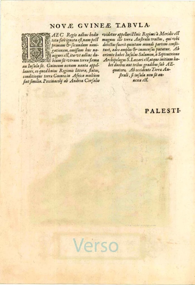
A long Latin note on New Guinea states that it is not certain whether it is an island or part of a southern continent.
Comments in the atlas about this map: "This region is even today almost unknown, because after the first and second voyages all have avoid from sailing thither so that it is doubtful even until today whether it is a continent or an island. The sailors called this region New Guinea because its coasts, state and conditions are similar in many respects to the African Guinea. Andreas Cosalius seems to call it Peccinacolij. After this region the huge Australian land follows which - as soon as it is once known - will represent a fifth continent, so vast and immense is it deemed. In the east the Solomon Islands join up, in the north the S. Lazarus Archipelago; it takes its beginning at two or three degrees south of the equator. In the west it is, if not an island, connected up with the Australian continent."
Gerard and Cornelis de Jode
Gerard de Jode (Judaeus) (1508(?)-1591), a native of Nijmegen, began his career as a printer and engraver in Antwerp about 1550. He lived near the Bourse on the Catelijne Veste, or on "de Catte". He was in regular contact with Christoffel Plantin, to whom he sold many prints and maps. De Jode's business, which must have been a major one among Antwerp's many booksellers and printers, was represented at the Frankfurt fair, where de Jode bought maps that he later copied or re-sold. Most of the maps sold by De Jode have prototypes of Italian or German origin. Apart from his many separately published maps, Gerard de Jode is known for his atlas, Speculum Orbis Terrarum, published in 1578. Part of the engraving was done by himself, and part by brothers Jan and Lucas van Doetecum.
Gerard de Jode and Abraham Ortelius, who partly lived as map sellers, were competitors and only sometimes on good terms.
After the death of Gerard de Jode in 1591, the business was carried on by his widow, Pascale van Gelder and his son, Cornelis (1568-1600). More a publisher than an engraver, the latter reissued the Speculum in 1593, adding new maps and revising others.
Despite all its deficiencies, the Speculum must have had a good reputation. It is mentioned alongside Mercator's Atlas and Ortelius's Theatrum in Petrus Montanus's preface to the Germania Inferior of Pieter van den Keere.
Novae Guineae Forma & Situs.
Item Number: 25197 Authenticity Guarantee
Category: Antique maps > Australia
Old, antique map of New Guinea and the Solomon Islands - Australia by de Jode
Date of the first edition: 1593
Date of this map: 1593
Copper engraving
Size: 34.5 x 21.5cm (13.5 x 8.4 inches)
Verso text: Latin
Condition: Superb bright old colouring, wide margins, excellent.
Condition Rating: A+
References: Van der Krogt 3, 9132:32; Tooley (Australia), p.55, 385; Schilder (Australia), p.268, 13.
From: Speculum Orbis Terrae. Antwerpen, G. De Jode, 1593. (Van der Krogt 3, 2:02)
The map is beautifully adorned with mythical sea creatures and ships.
Being issued in only one edition the map is very rare. There is only one known state of it.
A long Latin note on New Guinea states that it is not certain whether it is an island or part of a southern continent.
Comments in the atlas about this map: "This region is even today almost unknown, because after the first and second voyages all have avoid from sailing thither so that it is doubtful even until today whether it is a continent or an island. The sailors called this region New Guinea because its coasts, state and conditions are similar in many respects to the African Guinea. Andreas Cosalius seems to call it Peccinacolij. After this region the huge Australian land follows which - as soon as it is once known - will represent a fifth continent, so vast and immense is it deemed. In the east the Solomon Islands join up, in the north the S. Lazarus Archipelago; it takes its beginning at two or three degrees south of the equator. In the west it is, if not an island, connected up with the Australian continent."
Gerard and Cornelis de Jode
Gerard de Jode (Judaeus) (1508(?)-1591), a native of Nijmegen, began his career as a printer and engraver in Antwerp about 1550. He lived near the Bourse on the Catelijne Veste, or on "de Catte". He was in regular contact with Christoffel Plantin, to whom he sold many prints and maps. De Jode's business, which must have been a major one among Antwerp's many booksellers and printers, was represented at the Frankfurt fair, where de Jode bought maps that he later copied or re-sold. Most of the maps sold by De Jode have prototypes of Italian or German origin. Apart from his many separately published maps, Gerard de Jode is known for his atlas, Speculum Orbis Terrarum, published in 1578. Part of the engraving was done by himself, and part by brothers Jan and Lucas van Doetecum.
Gerard de Jode and Abraham Ortelius, who partly lived as map sellers, were competitors and only sometimes on good terms.
After the death of Gerard de Jode in 1591, the business was carried on by his widow, Pascale van Gelder and his son, Cornelis (1568-1600). More a publisher than an engraver, the latter reissued the Speculum in 1593, adding new maps and revising others.
Despite all its deficiencies, the Speculum must have had a good reputation. It is mentioned alongside Mercator's Atlas and Ortelius's Theatrum in Petrus Montanus's preface to the Germania Inferior of Pieter van den Keere.

