
Old, antique map of Southeast Asia by A. Ortelius 1612
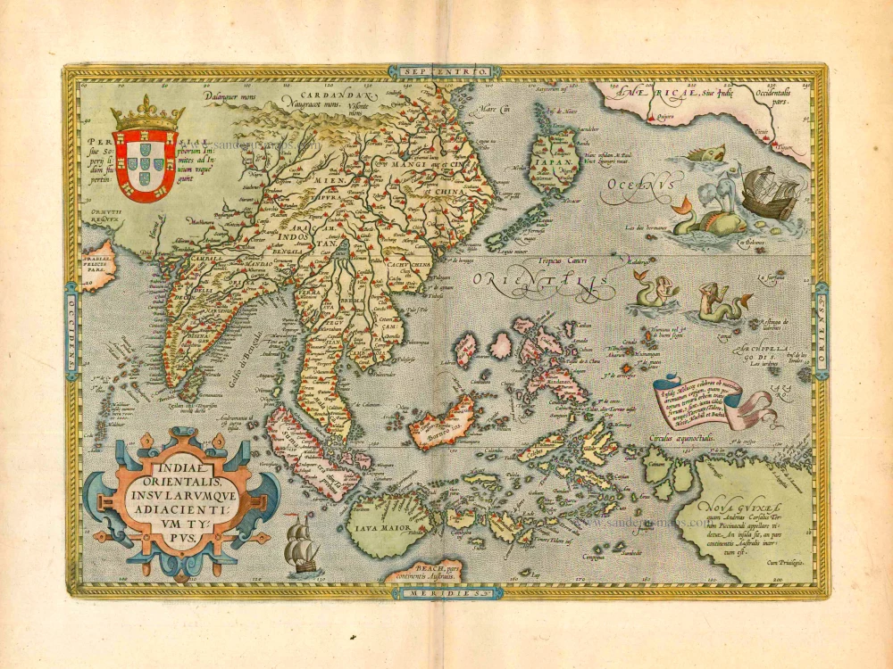


Adiacientium Typus.
Item Number: 5152 Authenticity Guarantee
Category: Antique maps > Australia
Old, antique map of Southeast Asia by A. Ortelius
Date of the first edition: 1570
Date of this map: 1612
Copper engraving
Size: 35 x 50cm (13.7 x 19.5 inches)
Verso text: Latin
Condition: Contemporary old coloured, mint.
Condition Rating: A+
References: Van der Krogt 3, 8400:31; Van den Broecke, 166
From: Theatrum Orbis Terrarum Abrahami Ortelii Antverp. Antwerpen, Plantin Press (J. & B. Moretus), 1612. (Van der Krogt 3, 1:055)
"This map represents a synthesis of the best readily available information on Southeast Asia and the East Indian Islands from Italian, Portugese and Spanish sources. The map extends from Portugese India in the west, through China, Japan, Southeast Asia and the East Indies (Indonesian archipelago), including New Guinea, to the Northwest coast of America. Sumatra and Java are shown heavily distorted in shape together with the principal spice islands, but the emergent shape of Borneo and the Philippines is apparent as well as the general configuration of the East Indian archipelago. Java is shown as an island but with a greatly inflated shape and no topographical information along the south coast, separated from Beach, a presumed promonotory on the southern or 'fifth' continent. Borneo is mapped in the place of the ficticious 'Java Minor' that frequently appeared at that latitude on the 'modern' Ptolemaic maps of the region, although only the part of Borneo north of the equator is shown to the west of a barely recognizable Celebes (Sulawesi), where no hint is given of the very distinctive peninsula geography of the island. On the other hand, the clove-producing islands of Ternate, Tidore and their neighbours to the south, Machian and Bacam, are correctly located to the west of the easily identifiable island of Gilolo (Halmahera) with its four distinctive peninsulas. Buru island is located correctly to the west of the main Ambon island, now called Seram, and although the 'Bird's Head' part of New Guinea (Irian Jaya) is shown as three islands, the outline of the coasts, particularly the north coast, strongly suggests that Ortelius based his information on actual charts of the coasts. Gebe island, where the French obtained the first clove and nutmeg seedlings they smuggled out in the eighteenth century and which currently contains one of Indonesia's largest nickel mines, is correctly located on the equador between Gilolo and New Guinea. The map 'Indiae Orientalis Insularumque Adiacentium Typus' by Ortelius is a 'milestone' map in the cartograpy of Southeast Asia and the East Indian Islands. It represents the synthesis of cartographic knowledge of the region for the first seventy years of the sixteenth century and, most importantly, brought that knowledge to a very wide audience through the numerous editions of the Theatrum. The map must be considered one of the gems of any private collection of maps of the region and, somewhat surprisingly, is still available for collectors at a reasonable price." (Parry, p.76-78)