
Old antique World map by Philip Eckebrecht, commissioned by Johan Kepler. 1658+
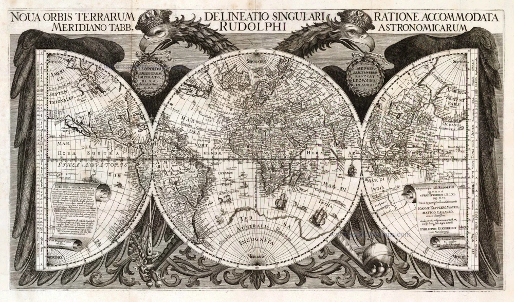
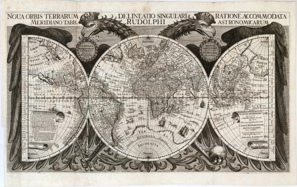


Nova Orbis Terrarum Delineatio Singulari Ratione Accommodata Meridiano Tabb. Rudolphi Astronomicarum.
Item Number: 2385 Authenticity Guarantee
Category: Antique maps > Australia
Old, antique world map by Philip Eckebrecht, commissioned by Johan Kepler.
Conceived by Ph. Eckebrecht c. 1627-30, published c. 1658.
Date on map: 1630.
Engraver: J.P. Walch.
Copper engraving
Size (not including margins): 38.5 x 68.5cm (15 x 26.7 inches)
Verso: Blank
Condition: Excellent.
Condition Rating: A+
References: Shirley (World), 335; Clancy, p.76 Map 6.4.
From: Kepler J. Tabulae Rudolphinae. Ulm, J. Saur, 1627.
The Tabulae Rudolphinae consist of a star catalogue and planetary tables published by Johannes Kepler in 1627, using some observational data collected by Tycho Brahe (1546–1601). The tables are named as "Rudolphine" in memory of Rudolf II, Holy Roman Emperor. It was the first scientific publication to use the newly published system of logarithms.
The map is one of the most visually dramatic world maps, dominated by the German Imperial double-headed eagle holding all the world in its wings, an allegory of imperial protection under which the map was created. The special feature of this world map is the nature of the division of the earth's surface into three partial figures, constructed so that the prime meridian would pass through Uraniborg, Tycho Brahe's observatory on the island of Hven, the leading European centre of astronomical research during the first years of the seventeenth century.
A panel of text within the map describes the origin of the map - commissioned by Johann Kepler for his book Tabulae Rudolphinae, conceived and drawn by Philip Eckebrecht, and engraved by J.P. Walsh in 1630. However, all copies must have been issued considerably later, certainly not before 1658 when the Emperor Leopold to whom the map is dedicated came to the throne. This caused some doubts about whether the geography is of 1630 or circa 1658. The map shows the Dutch discoveries in Australia, combining the discoveries of Hartog, in 1616, and Houtman, in 1619, on the west coast, and those of Carstenz. and Colsten along the northern coast, in 1623. If the map was designed c. 1630 then it was one of the earliest maps to show the Dutch discoveries in Australia.
In 2014, Peter Meurer published an article about the discovery of a proof state of the Eckebrecht map, bound in a 1630 issue of the Kepler book in the University Library in Kiel (Germany). (Cartographica Helvetica, Vol.49 (2014), p.27-38).
As suspected from Kepler's letters, there was an unfinished proof state in 1630. The proof state has the two hemispheres, but the eagles and other outer decorations are only sketched. There is no dedication to Emperor Leopold I. This proof state has many differences in North America: The Great Lakes and New Netherland are not yet there, California is not yet an island. The map has the West Australian coastline, making it a cornerstone map for Australia.
The coast of West Australia is a one-on-one copy from the 1622-1624 Hondius world map (first map to show any of the Dutch discoveries in Australia). The discoveries of the Duyfken and of the Arnhem and Pera are not yet on this 1630 proof state.
This means that Kepler had no "firsts" for Australia, but he used the most recent maps and the latest information available for Australia. His world map is among the first printed maps that show the discoveries of Australia.
According to Meurer, Kepler must have started working on the manuscript map no later than 1626. Because of personal adverse conditions, the map was not finished when the Tabulae Rudolphinae was published in 1627. Kepler handed over his concept and material to his confidant Philip Eckebrecht. By the end of 1630, the engraving of the map had been finished in Nuremberg. Because of the deaths of Kepler (1630) and the engraver Johann Philipp Walch (1631). the printing was not used. It seems that the coronation of Leopold I in 1658 was the reason this map was updated and subsequently published in this form for the first time.
Shirley: "Only very rarely is Eckebrecht's map found on the open market".