
Rare and important map!
Celestial chart and astronomical calculator by Claes Jansz. Vooght, published by J. Van Keulen. 1709
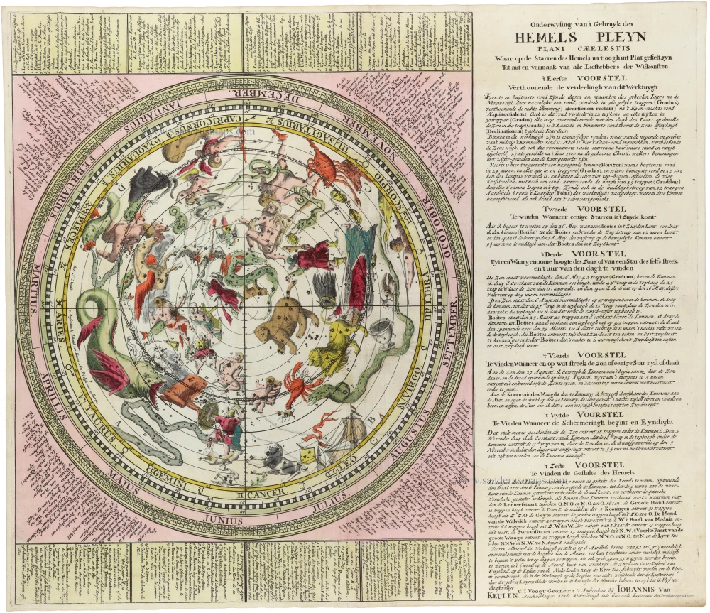


Rare celestial chart and astronomical calculator by C.J. Vooght.
Using a volvelle (a rotating paper ring) mounted on an eccentric axle, celestial calculations could be performed for the Dutch latitude of 52 degrees.
Fifty-three constellations are numbered by quarter (15, 9, 14, 15), with a Dutch legend in each corner and French and English translations in strips of panels at the top and bottom. The instructional text, describing six "voorstellen" (suggestions; the first explains the various scales, etc., and the others provide examples of using the chart), is located to the right of the chart and printed on a single plate along with the text.
back
Cartographer: C.J. Vooght.
Designer: Jan Jansz. Stampioen.
Date of the first edition: 1709.
Date of this map: 1709.
Copper engraving, printed on paper. Without the volvelle.
Image size: 525 x 410mm (20¾ x 16¼ inches).
Sheet size: 535 x 625mm (21 x 24½ inches).
Verso: Blank.
Condition: Original coloured, excellent.
Condition Rating: A+.
From: De Groote Nieuwe Vermeerderde Zee-Atlas, ofte Water-Waereld. Amsterdam, Ioannes van Keulen, 1709. (Koeman IV, p. 297, Keu28)
References: Koeman - IV p. 297 Keu28 (6) & p. 370 [272]; In de Gekroonde Lootsman - p. 84 #4; de Vries, Schilder, ... (Van Keulen) - p. 207, #240; Warner - p. 260, 1a
Onderwysing van't Gebruyk des Hemels Pleyn Waar op de starren des hemels na 't oogh in 't plat gestelt zyn[
€7000
($8330 / £6020)
add to cart
Buy now
questions?
PRINT
Item Number: 32701 new Authenticity Guarantee
Category: Antique maps > Celestial Maps
Celestial chart and astronomical calculator by Claes Jansz. Vooght, published by J. Van Keulen.
Title: Onderwysing van't Gebruyk des Hemels Pleyn Waar op de starren des hemels na 't oogh in 't plat gestelt zyn[
Tot nut en vermaak van alle liefhebbers der wiskonsten.
C.I. Voogt Geometra 't Amsterdam by Iohannis Van Keulen. Boekverkooper aande Nieuw-brugh inde Gekroonde Lootsman Met Previlegio voor 15 Iaaren.
Cartographer: C.J. Vooght.
Designer: Jan Jansz. Stampioen.
Date of the first edition: 1709.
Date of this map: 1709.
Copper engraving, printed on paper. Without the volvelle.
Image size: 525 x 410mm (20¾ x 16¼ inches).
Sheet size: 535 x 625mm (21 x 24½ inches).
Verso: Blank.
Condition: Original coloured, excellent.
Condition Rating: A+.
From: De Groote Nieuwe Vermeerderde Zee-Atlas, ofte Water-Waereld. Amsterdam, Ioannes van Keulen, 1709. (Koeman IV, p. 297, Keu28)
Rare celestial chart and astronomical calculator by C.J. Vooght.
Using a volvelle (a rotating paper ring) mounted on an eccentric axle, celestial calculations could be performed for the Dutch latitude of 52 degrees.
Fifty-three constellations are numbered by quarter (15, 9, 14, 15), with a Dutch legend in each corner and French and English translations in strips of panels at the top and bottom. The instructional text, describing six "voorstellen" (suggestions; the first explains the various scales, etc., and the others provide examples of using the chart), is located to the right of the chart and printed on a single plate along with the text.