
First edition, heightened in gold.
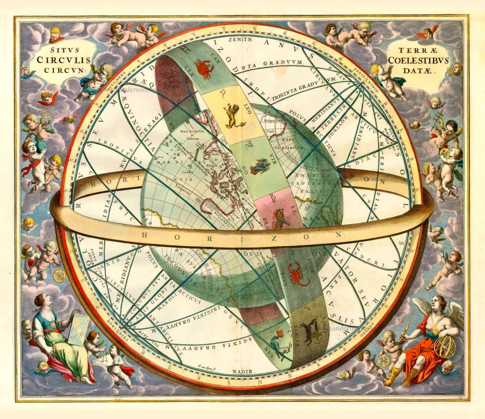
The globe of the earth surrounded by zodiacal bands, with tropical and equatorial circles, by Andreas Cellarius. 1660
Andreas Cellarius (Heidelberg, c. 1596 - Hoorn, 1665)
Andreas Cellarius enrolled at Heidelberg University in 1613. Then, after several years as a schoolmaster in The Hague, he became the rector of the Latin School at Hoorn around 1637.
His connection with the Janssonius publishing firm dates from around 1645. This year, Jodocus Janssonius, Johannes's son, published Cellarius's Architectura Militaris, work on fortifications. In 1652 the Amsterdam publisher Gillis Jansz. Valckenier published Cellarius's Regni Poloniae … with 21 maps.
In 1660, Joannes Janssonius added a celestial atlas to his Atlas Major, the beautiful Harmonia Macrocosmica by Andreas Cellarius. In 1661 the atlas was republished as a separate publication. The plates of the Harmonia Macrocosmica were reprinted (without the Latin commentary) in 1708 by the Amsterdam publishers Valk and Schenk.
The Harmonia Macrocosmica is the most beautiful celestial atlas ever published and is one of the notable masterworks from the Golden Age of Dutch cartography. The first part of the atlas contains engravings depicting the world systems of Claudius Ptolemy, Nicolaus Copernicus, and Tycho Brahe. At the end are star maps of the classical and further constellations.
The Janssonius Family
Joannes Janssonius (Arnhem, 1588-1664), son of the Arnhem publisher Jan Janssen, married Elisabeth Hondius, daughter of Jodocus Hondius, in Amsterdam in 1612. After his marriage, he settled down in this town as a bookseller and publisher of cartographic material. In 1618, he established himself in Amsterdam next door to Blaeu’s bookshop. He entered into serious competition with Willem Jansz. Blaeu when copying Blaeu’s Licht der Zeevaert after the expiration of the privilege in 1620. His activities concerned the publication of atlases, books, single maps, and an extensive book trade with branches in Frankfurt, Danzig, Stockholm, Copenhagen, Berlin, Koningsbergen, Geneva, and Lyon. In 1631, he began publishing atlases together with Henricus Hondius.
In the early 1640s, Henricus Hondius left the atlas publishing business to Janssonius. Competition with Joan Blaeu, Willem’s son and successor, in atlas production, prompted Janssonius to enlarge his Atlas Novus finally into a work of six volumes, into which a sea atlas and an atlas of the Old World were inserted. Other atlases published by Janssonius are Mercator’s Atlas Minor, Hornius’s historical atlas (1652), the townbooks in eight volumes (1657), Cellarius’s Atlas Coelestis and several sea atlases and pilot guides.
After the death of Joannes Janssonius, the shop and publishing firm were continued by the heirs under the direction of Johannes van Waesbergen (c. 1616-1681), son-in-law of Joannes Janssonius. Van Waesbergen added Janssonius's name to his own.
In 1676, Joannes Janssonius’s heirs sold by auction “all the remaining Atlases in Latin, French, High and Low German, as well as the Stedeboecken in Latin, in 8 volumes, bound and unbound, maps, plates belonging to the Atlas and Stedeboecken.” The copperplates from Janssonius’s atlases were afterwards sold to Schenk and Valck.
Situs Terrae Circulis Coelestibus Circundatae.
Item Number: 27432 Authenticity Guarantee
Category: Antique maps > Celestial Maps
Antique chart, showing the globe of the earth surrounded by zodiacal bands, with tropical and equatorial circles, by Andreas Cellarius.
Engraver: Jan van Loon
Date of the first edition: 1660
Date of this map: 1660
Copper engraving, printed on paper.
Size (not including margins): 43 x 51cm (16.8 x 19.9 inches)
Verso: Blank
Condition: Original coloured, heightened in gold, excellent.
Condition Rating: A+
References: Van der Krogt 1, HM11:1 - State 1.
From: A Cellarius, Harmonia Macrocosmica sea Atlas Coelestis. J. Janssonius, 1660. (Van der Krogt 1, 801A)
Andreas Cellarius (Heidelberg, c. 1596 - Hoorn, 1665)
Andreas Cellarius enrolled at Heidelberg University in 1613. Then, after several years as a schoolmaster in The Hague, he became the rector of the Latin School at Hoorn around 1637.
His connection with the Janssonius publishing firm dates from around 1645. This year, Jodocus Janssonius, Johannes's son, published Cellarius's Architectura Militaris, work on fortifications. In 1652 the Amsterdam publisher Gillis Jansz. Valckenier published Cellarius's Regni Poloniae … with 21 maps.
In 1660, Joannes Janssonius added a celestial atlas to his Atlas Major, the beautiful Harmonia Macrocosmica by Andreas Cellarius. In 1661 the atlas was republished as a separate publication. The plates of the Harmonia Macrocosmica were reprinted (without the Latin commentary) in 1708 by the Amsterdam publishers Valk and Schenk.
The Harmonia Macrocosmica is the most beautiful celestial atlas ever published and is one of the notable masterworks from the Golden Age of Dutch cartography. The first part of the atlas contains engravings depicting the world systems of Claudius Ptolemy, Nicolaus Copernicus, and Tycho Brahe. At the end are star maps of the classical and further constellations.
The Janssonius Family
Joannes Janssonius (Arnhem, 1588-1664), son of the Arnhem publisher Jan Janssen, married Elisabeth Hondius, daughter of Jodocus Hondius, in Amsterdam in 1612. After his marriage, he settled down in this town as a bookseller and publisher of cartographic material. In 1618, he established himself in Amsterdam next door to Blaeu’s bookshop. He entered into serious competition with Willem Jansz. Blaeu when copying Blaeu’s Licht der Zeevaert after the expiration of the privilege in 1620. His activities concerned the publication of atlases, books, single maps, and an extensive book trade with branches in Frankfurt, Danzig, Stockholm, Copenhagen, Berlin, Koningsbergen, Geneva, and Lyon. In 1631, he began publishing atlases together with Henricus Hondius.
In the early 1640s, Henricus Hondius left the atlas publishing business to Janssonius. Competition with Joan Blaeu, Willem’s son and successor, in atlas production, prompted Janssonius to enlarge his Atlas Novus finally into a work of six volumes, into which a sea atlas and an atlas of the Old World were inserted. Other atlases published by Janssonius are Mercator’s Atlas Minor, Hornius’s historical atlas (1652), the townbooks in eight volumes (1657), Cellarius’s Atlas Coelestis and several sea atlases and pilot guides.
After the death of Joannes Janssonius, the shop and publishing firm were continued by the heirs under the direction of Johannes van Waesbergen (c. 1616-1681), son-in-law of Joannes Janssonius. Van Waesbergen added Janssonius's name to his own.
In 1676, Joannes Janssonius’s heirs sold by auction “all the remaining Atlases in Latin, French, High and Low German, as well as the Stedeboecken in Latin, in 8 volumes, bound and unbound, maps, plates belonging to the Atlas and Stedeboecken.” The copperplates from Janssonius’s atlases were afterwards sold to Schenk and Valck.
Related items
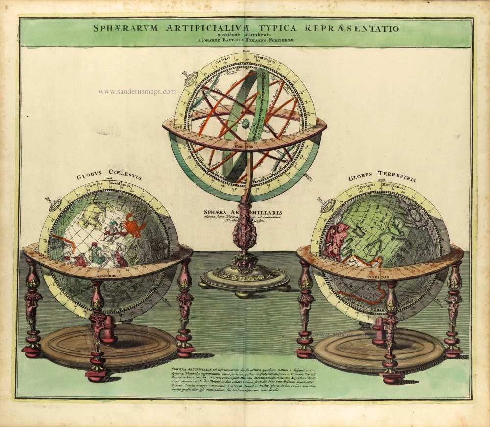
Sphaerarum Artificialium Typica Repraesentatio Novissime Adumbrata. 1730-37
Armillary sphere, terrestrial & celestial globes by Johann Baptist Homann.
[Item number: 28361]
Superb old colouring, heightened with gold.
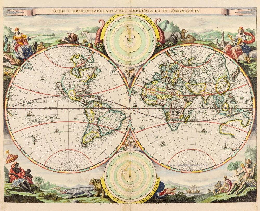
Orbis Terrarum Tabula Recens Emendata Et In Lucem Edita 1714
World - Double Hemisphere, by Daniel Stoopendaal
[Item number: 30635]
First edition, heightened in gold.
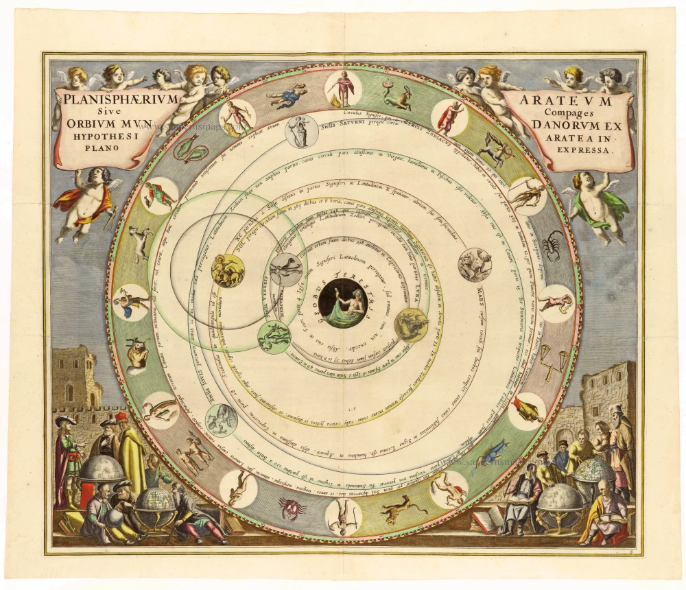
Planishaerium Arateum Sive Compages Orbium Mundanorum ex Hypothesi Aratea in Plano Expressa. 1660
Geocentric celestial chart based on the observations of Greek didactic poet Aratus (c. 315/310 - 240 BC), by Andreas Cellarius.
[Item number: 30788]
First edition, heightened in gold.
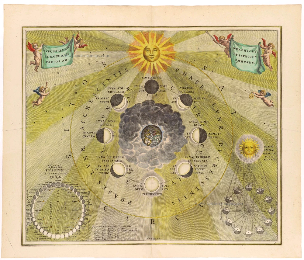
Typus Selenographicus Lunæ Phases et Aspectus Varios Adumbrans. 1660
Diagram of the moon, by Andreas Cellarius.
[Item number: 30789]