
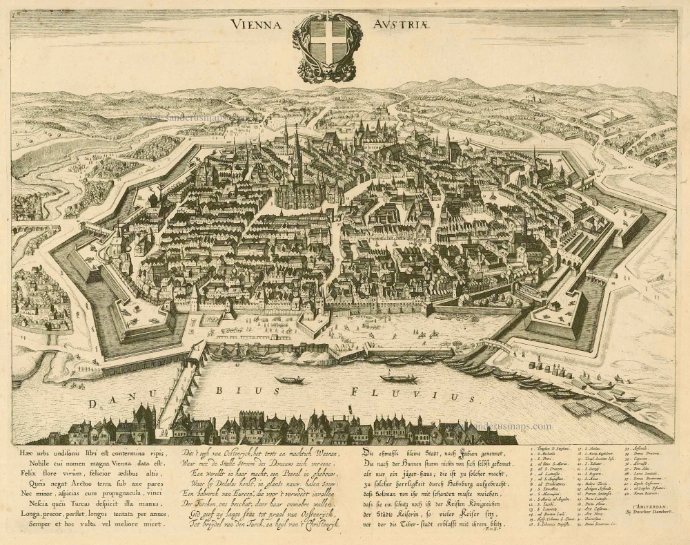
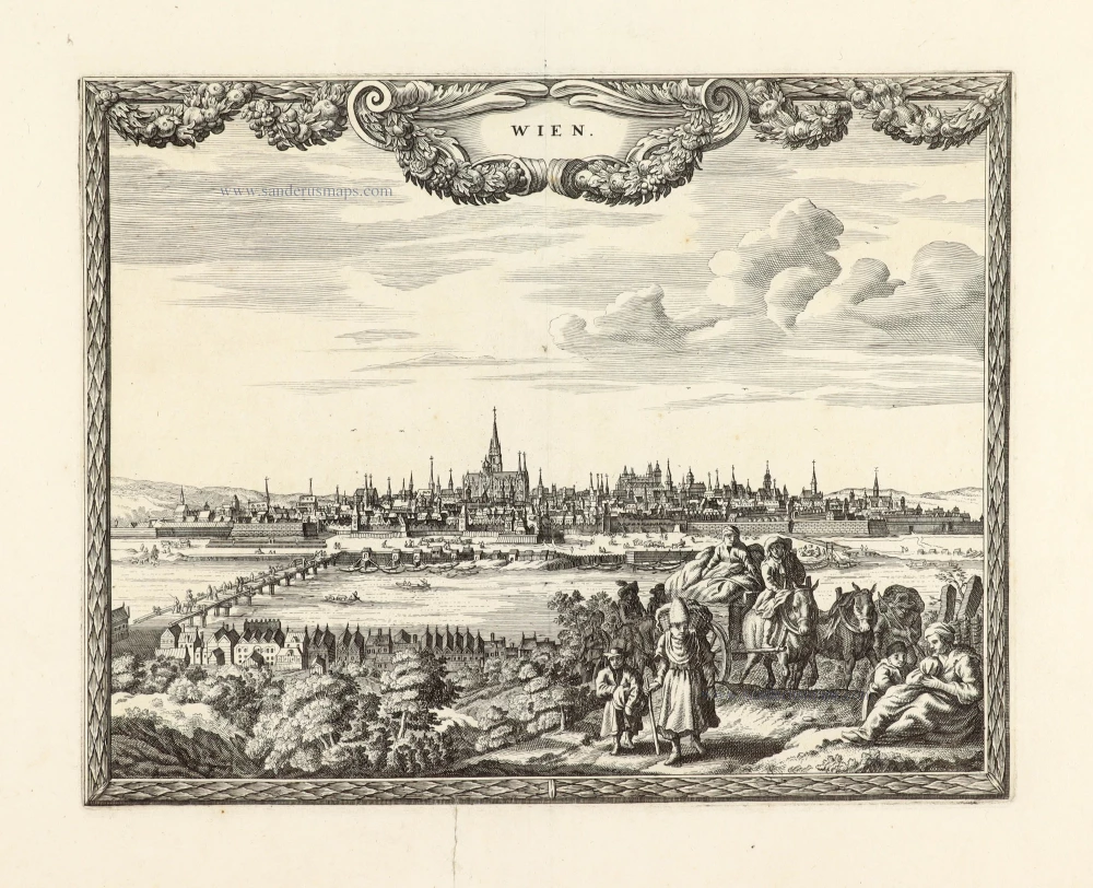
Wien, by Georg Braun and Frans Hogenberg. 1572

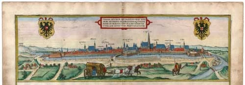

TRANSLATION OF CARTOUCHE TEXT: Vienna, Austria's capital, a city known and famed worldwide, is the only bulwark in the east unconquered by the ferocious Turks.
COMMENTARY BY BRAUN: "Vienna is an important city with impregnable walls that are so secure that Vienna can be called the protector of Christianity against the blood-thirsty Turks. Vienna's suburbs are large and magnificent. The churches constructed to the glory of God and the saints are very finely decorated and appear almost transparent, even though they are made of hard-hewn stone; the noblest amongst them is St Stephen's. Vienna also has a very praiseworthy university, implanted here from Rome and Paris around 1337 by Emperor Frederick II."
Vienna is shown in a profile view from the west, with Kahlenberg Hill on the far left. In the second half of the 12th century, Vienna developed into the residence of the Duchy of Austria and a city wall was built around it at the beginning of the 13th century. In 1221 Vienna was granted a municipal charter, the university was founded in 1365, and the city became an episcopal see in 1469. In the 15th century, trade declined, but the city's position as the residence of the Holy Roman Empire was able to compensate for the commercial losses. After the Siege of Vienna by the Ottoman army in 1529, the city's fortifications were rebuilt. The new fortifications, highly praised by Braun, resisted another Turkish siege before the Battle of Vienna in 1683. (Taschen)
Braun G. & Hogenberg F. and the Civitates Orbis Terrarum.
The Civitates Orbis Terrarum, also known as the 'Braun & Hogenberg', is a six-volume town atlas and the most excellent book of town views and plans ever published: 363 engravings, sometimes beautifully coloured. It was one of the best-selling works in the last quarter of the 16th century. Georg Braun, a skilled writer, wrote the text accompanying the plans and views on the verso. Many plates were engraved after the original drawings of a professional artist, Joris Hoefnagel (1542-1600). The first volume was published in Latin in 1572 and the sixth in 1617. Frans Hogenberg, a talented engraver, created the tables for volumes I through IV, and Simon van den Neuwel made those for volumes V and VI. Other contributors were cartographers Daniel Freese and Heinrich Rantzau, who provided valuable geographical information. Works by Jacob van Deventer, Sebastian Münster, and Johannes Stumpf were also used as references. Translations appeared in German and French, making the atlas accessible to a broader audience.
Since its original publication of volume 1 in 1572, the Civitates Orbis Terrarum has left an indelible mark on the history of cartography. Seven more editions followed the first volume in 1575, 1577, 1582, 1588, 1593, 1599, and 1612. Vol.2, initially released in 1575, saw subsequent editions in 1597 and 1612. The subsequent volumes, each a treasure trove of historical insights, graced the world in 1581, 1588, 1593, 1599, and 1606. The German translation of the first volume, a testament to its widespread appeal, debuted in 1574, followed by the French edition in 1575.
Several printers were involved: Theodor Graminaeus, Heinrich von Aich, Gottfried von Kempen, Johannis Sinniger, Bertram Buchholtz, and Peter von Brachel, all of whom worked in Cologne.
Georg Braun (1541-1622)
Georg Braun, the author of the text accompanying the plans and views in the Civitates Orbis Terrarum, was born in Cologne in 1541. After his studies in Cologne, he entered the Jesuit Order as a novice, indicating his commitment to learning and intellectual pursuits. In 1561, he obtained his bachelor's degree; in 1562, he received his Magister Artium, further demonstrating his academic achievements. Although he left the Jesuit Order, he continued his studies in theology, gaining a licentiate in theology. His theological background likely influenced the content and tone of the text in the Civitates Orbis Terrarum, adding a unique perspective to the work.
Frans Hogenberg (1535-1590)
Frans Hogenberg was a Flemish and German painter, engraver, and mapmaker. He was born in Mechelen as the son of Nicolaas Hogenberg.
By the end of the 1560s, Frans Hogenberg was employed upon Abraham Ortelius's Theatrum Orbis Terrarum, published in 1570; he is named an engraver of numerous maps. In 1568, he was banned from Antwerp by the Duke of Alva and travelled to London, where he stayed a few years before emigrating to Cologne. He immediately embarked on his two most important works, the Civitates, published in 1572 and the Geschichtsblätter, which appeared in several series from 1569 until about 1587.
Thanks to large-scale projects like the Geschichtsblätter and the Civitates, Hogenberg's social circumstances improved with each passing year. He died as a wealthy man in Cologne in 1590.
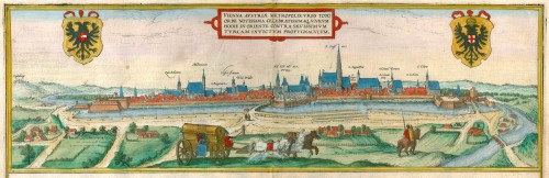
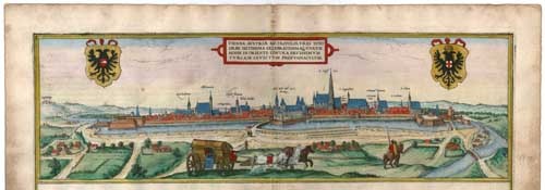
Vienna Austriae Metropolis, Urbs Toto Orbe Notissima Celebratissimaq, Unicum Hodie in Oriente contra Saevissimum Turcam Invictum Propugnacvium
Item Number: 21881 Authenticity Guarantee
Category: Antique maps > Europe > Austria
Old, antique bird’s-eye view plan of Wien, by Georg Braun and Frans Hogenberg.
Title: Vienna Austriae Metropolis, Urbs Toto Orbe Notissima Celebratissimaq, Unicum Hodie in Oriente contra Saevissimum Turcam Invictum Propugnacvium.
Date of the first edition: 1572.
Date of this map: 1572.
Copper engraving, printed on paper.
Size (not including margins): 150 x 470mm (5.91 x 18.5 inches).
Verso: Latin text.
Condition: Original coloured, excellent.
Condition Rating: A+.
From: Civitates Orbis Terrarum, Liber Primus. Cologne, Theodor Graminaeus, 1572.. (Van der Krogt 4, 41:0)
TRANSLATION OF CARTOUCHE TEXT: Vienna, Austria's capital, a city known and famed worldwide, is the only bulwark in the east unconquered by the ferocious Turks.
COMMENTARY BY BRAUN: "Vienna is an important city with impregnable walls that are so secure that Vienna can be called the protector of Christianity against the blood-thirsty Turks. Vienna's suburbs are large and magnificent. The churches constructed to the glory of God and the saints are very finely decorated and appear almost transparent, even though they are made of hard-hewn stone; the noblest amongst them is St Stephen's. Vienna also has a very praiseworthy university, implanted here from Rome and Paris around 1337 by Emperor Frederick II."
Vienna is shown in a profile view from the west, with Kahlenberg Hill on the far left. In the second half of the 12th century, Vienna developed into the residence of the Duchy of Austria and a city wall was built around it at the beginning of the 13th century. In 1221 Vienna was granted a municipal charter, the university was founded in 1365, and the city became an episcopal see in 1469. In the 15th century, trade declined, but the city's position as the residence of the Holy Roman Empire was able to compensate for the commercial losses. After the Siege of Vienna by the Ottoman army in 1529, the city's fortifications were rebuilt. The new fortifications, highly praised by Braun, resisted another Turkish siege before the Battle of Vienna in 1683. (Taschen)
Braun G. & Hogenberg F. and the Civitates Orbis Terrarum.
The Civitates Orbis Terrarum, also known as the 'Braun & Hogenberg', is a six-volume town atlas and the most excellent book of town views and plans ever published: 363 engravings, sometimes beautifully coloured. It was one of the best-selling works in the last quarter of the 16th century. Georg Braun, a skilled writer, wrote the text accompanying the plans and views on the verso. Many plates were engraved after the original drawings of a professional artist, Joris Hoefnagel (1542-1600). The first volume was published in Latin in 1572 and the sixth in 1617. Frans Hogenberg, a talented engraver, created the tables for volumes I through IV, and Simon van den Neuwel made those for volumes V and VI. Other contributors were cartographers Daniel Freese and Heinrich Rantzau, who provided valuable geographical information. Works by Jacob van Deventer, Sebastian Münster, and Johannes Stumpf were also used as references. Translations appeared in German and French, making the atlas accessible to a broader audience.
Since its original publication of volume 1 in 1572, the Civitates Orbis Terrarum has left an indelible mark on the history of cartography. Seven more editions followed the first volume in 1575, 1577, 1582, 1588, 1593, 1599, and 1612. Vol.2, initially released in 1575, saw subsequent editions in 1597 and 1612. The subsequent volumes, each a treasure trove of historical insights, graced the world in 1581, 1588, 1593, 1599, and 1606. The German translation of the first volume, a testament to its widespread appeal, debuted in 1574, followed by the French edition in 1575.
Several printers were involved: Theodor Graminaeus, Heinrich von Aich, Gottfried von Kempen, Johannis Sinniger, Bertram Buchholtz, and Peter von Brachel, all of whom worked in Cologne.
Georg Braun (1541-1622)
Georg Braun, the author of the text accompanying the plans and views in the Civitates Orbis Terrarum, was born in Cologne in 1541. After his studies in Cologne, he entered the Jesuit Order as a novice, indicating his commitment to learning and intellectual pursuits. In 1561, he obtained his bachelor's degree; in 1562, he received his Magister Artium, further demonstrating his academic achievements. Although he left the Jesuit Order, he continued his studies in theology, gaining a licentiate in theology. His theological background likely influenced the content and tone of the text in the Civitates Orbis Terrarum, adding a unique perspective to the work.
Frans Hogenberg (1535-1590)
Frans Hogenberg was a Flemish and German painter, engraver, and mapmaker. He was born in Mechelen as the son of Nicolaas Hogenberg.
By the end of the 1560s, Frans Hogenberg was employed upon Abraham Ortelius's Theatrum Orbis Terrarum, published in 1570; he is named an engraver of numerous maps. In 1568, he was banned from Antwerp by the Duke of Alva and travelled to London, where he stayed a few years before emigrating to Cologne. He immediately embarked on his two most important works, the Civitates, published in 1572 and the Geschichtsblätter, which appeared in several series from 1569 until about 1587.
Thanks to large-scale projects like the Geschichtsblätter and the Civitates, Hogenberg's social circumstances improved with each passing year. He died as a wealthy man in Cologne in 1590.
Related items
Vienna Austria. c. 1660
Wien, by D. Danckerts.
[Item number: 7049]
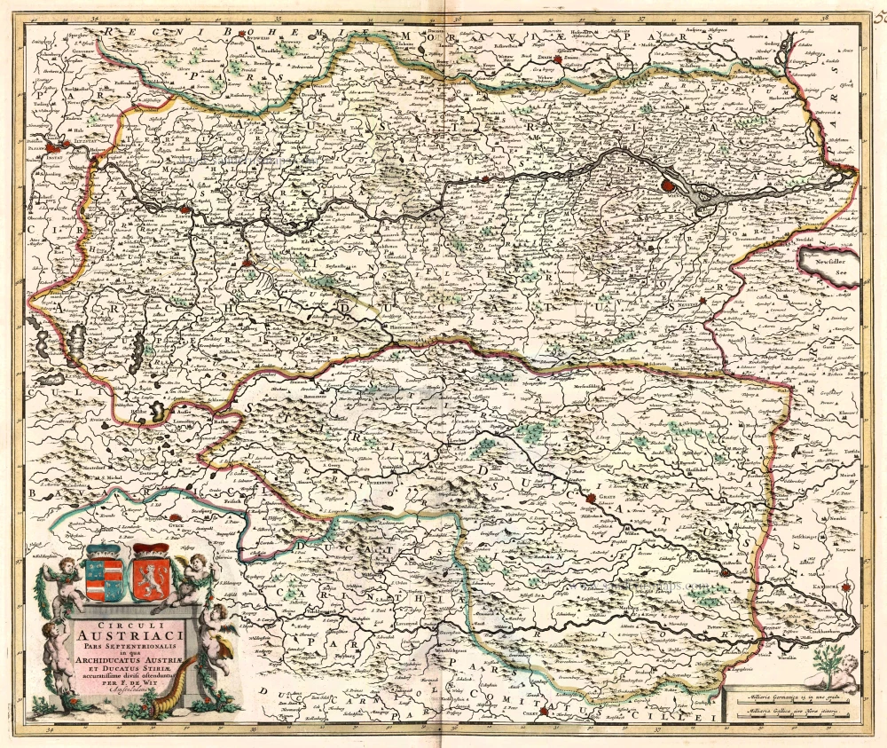
Circuli Austriaci pars Septentrionalis in qua Archiducatus Austriae et Ducatus Stiriae ... c. 1680
Northern Austria, by F. De Wit.
[Item number: 10567]
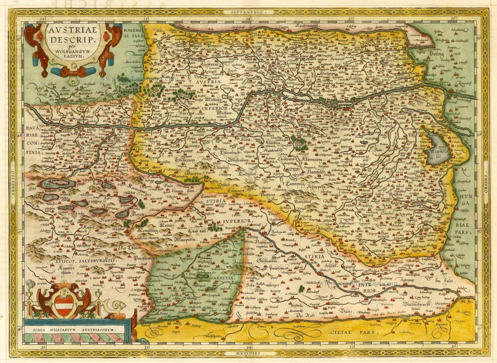
Austriae Descrip. per Wolfgangum Lazium. 1598
Austria, by A. Ortelius.
[Item number: 21893]
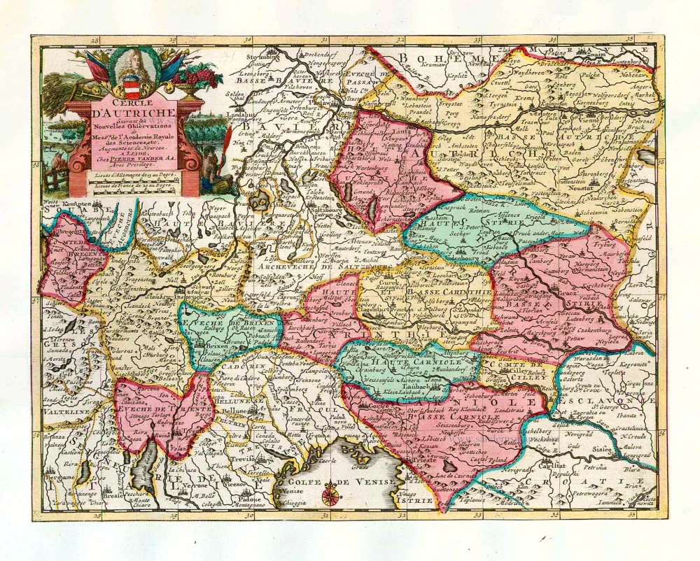
Cercle d'Autriche. 1713
Austria, by Pieter van der Aa.
[Item number: 26180]
Unrecorded variant of Schut's view of Wien, by Carel Allard
Wien. 1673
View of Wien by Carel Allard.
[Item number: 30563]