
Eisenstadtt - Mannersdorf by Braun & Hogenberg 1617-18
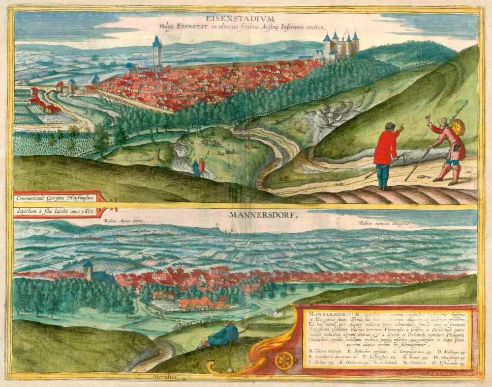
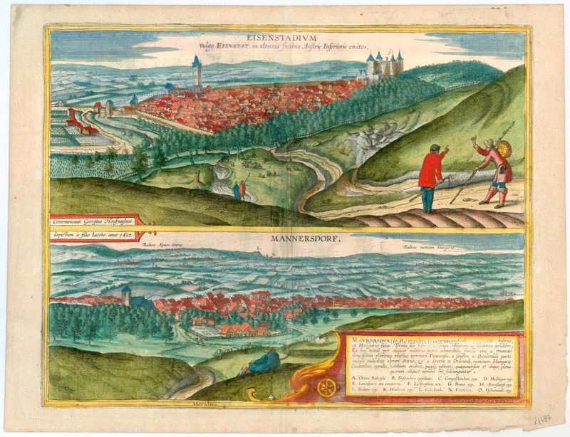


EISENSTADT
CAPTION: Eisenstadium, in German called Eisenstadt, a town on the eastern border of Austria.
CARTOUCHE: Procured by Georg Hoefnagel, drawn by his son Jakob in the year 1617.
COMMENTARY BY BRAUN (on verso): "It seems as if this city is named after the iron. It lies in Lower Austria between the River Leitha, which separates Hungary and Austria from each other, and the Neusiedler Lake, near the Hungarian border, on fertile land, which produces sufficient corn and wine, and pasture for cattle."
This is a view from the north, from the Leitha Mountains. The densely crowded town houses are watched over by the 14th-century four-tower castle of Kanizai, today's Esterhazy palace, built on a hill, and the late Gothic cathedral church of St Martin with its Renaissance tower. Fields, gardens and cattle indicate that the town was flourishing at the time. The wall constructed in 1371, following the granting of city wall rights, encloses an almost rectangular area. The two plainly dressed men in the foreground are carrying a hoe and a spear as symbols of the duties of soldier-farmers. Documented for the first time in 1118 as a castrum ferreum, the town passed into the possession of the Kanizsai family in the mid-14th century.
MANNERSDORF AT THE FOOT OF MOUNT LEITHA
CARTOUCHE: Mannersdorf, a town on the border between Lower Austria and Hungary, famous for its hot springs or thermal baths. Below this hill an admirable plain stretches for miles, full of vines and grain, a part of the territory of Vienna, enclosed in the west on the left by the foothills of the Styrian Alps, and in the east on the right by the Hungarian mountains. It is covered with cities, towns, noble castles and countless villages, some of which are named below.
COMMENTARY BY BRAUN (on verso): "The town lies in a plain and is especially famous because of its thermal baths. To the south is a mountain from which one can see the whole plain. This plain, which is almost unique in Austria for its fertility, was sadly devastated by the Turks after the siege of Vienna in 1529 and many people were carried off into slavery. In 1578 the Turks advanced as far as Mödling and captured the town by force and ravaged it with extreme tyranny and cruelty, but they soon lost it again."
This is a view towards the north over the Vienna Basin and includes the Styrian Alps in the west and the Hungarian Alps in the east. Some towns and castles, such as Baden (A), Mödling (D) or Vienna (N), are roughly sketched in. The prosperity and peace of the region, underlined by the almost idyllic depiction of a shepherd in the foreground, contrasts markedly with the devastation of the Turkish Wars alluded to above. The Romanesque-Gothic parish church of St Martin stands out clearly on the left, in the middle the bathhouse and chapel, founded in 1517, can be identified. Mentioned for the first time in 1233, the town belonged to the Hungarian fiefdom up to end of the 15th century. After being devastated during the retreat of the Ottomans in 1529, the town was resettled by Croatian soldier-farmers. Because of the limestone quarries in the south, Mannersdorf has been important for the stonemason industry since the Middle Ages, and today is a centre of the cement industry.
Braun G. & Hogenberg F. and the Civitates Orbis Terrarum.
The Civitates Orbis Terrarum, or the "Braun & Hogenberg", is a six-volume town atlas and the most excellent book of town views and plans ever published: 363 engravings, sometimes beautifully coloured. It was one of the best-selling works in the last quarter of the 16th century. Georg Braun wrote the text accompanying the plans and views on the verso. Many plates were engraved after the original drawings of a professional artist, a professional artist, Joris Hoefnagel (1542-1600). The first volume was published in Latin in 1572, and the sixth in 1617. Frans Hogenberg created the tables for volumes I through IV, and Simon van den Neuwel made those for volumes V and VI. Other contributors were cartographers Daniel Freese and Heinrich Rantzau. Works by Jacob van Deventer, Sebastian Münster, and Johannes Stumpf were also used. Translations appeared in German and French.
Following the original publication of Volume 1 of the Civitates in 1572, seven further editions of 1575, 1577, 1582, 1588, 1593, 1599 and 1612 can be identified. Vol.2, first issued in 1575, was followed by further editions in 1597 and 1612. The subsequent volumes appeared in 1581, 1588, 1593, 1599 and 1606. The German translation of the first volume appeared from 1574 on, and the French edition from 1575 on.
Several printers were involved: Theodor Graminaeus, Heinrich von Aich, Gottfried von Kempen, Johannis Sinniger, Bertram Buchholtz and Peter von Brachel, who all worked in Cologne.
Georg Braun (1541-1622)
Georg Braun was born in Cologne in 1541. After his studies in Cologne, he entered the Jesuit Order as a novice. 1561, he obtained his bachelor's degree, and in 1562, he received his Magister Artium. Although he left the Jesuit Order, he studied theology, gaining a licentiate in theology.
Frans Hogenberg (1535-1590)
Frans Hogenberg was a Flemish and German painter, engraver, and mapmaker. He was born in Mechelen as the son of Nicolaas Hogenberg.
By the end of the 1560s, Frans Hogenberg was employed upon Abraham Ortelius's Theatrum Orbis Terrarum, published in 1570; he is named an engraver of numerous maps. In 1568, he was banned from Antwerp by the Duke of Alva and travelled to London, where he stayed a few years before emigrating to Cologne. He immediately embarked on his two most important works, the Civitates, published in 1572 and the Geschichtsblätter, which appeared in several series from 1569 until about 1587.
Thanks to large-scale projects like the Geschichtsblätter and the Civitates, Hogenberg's social circumstances improved with each passing year. He died as a wealthy man in Cologne in 1590.
Eisenstadium vulgo Eisnstat, in ultimis finibus Austria Inferioris civitas.[on sheet with:] Mannersdorf.
Item Number: 23427 Authenticity Guarantee
Category: Antique maps > Europe > Austria
Antique map with two bird's-eye views by Braun and Hogenberg: Eisenstadtt and Mannersdorf.
EISENSTADT
CAPTION: Eisenstadium, in German called Eisenstadt, a town on the eastern border of Austria.
CARTOUCHE: Procured by Georg Hoefnagel, drawn by his son Jakob in the year 1617.
COMMENTARY BY BRAUN (on verso): "It seems as if this city is named after the iron. It lies in Lower Austria between the River Leitha, which separates Hungary and Austria from each other, and the Neusiedler Lake, near the Hungarian border, on fertile land, which produces sufficient corn and wine, and pasture for cattle."
This is a view from the north, from the Leitha Mountains. The densely crowded town houses are watched over by the 14th-century four-tower castle of Kanizai, today's Esterhazy palace, built on a hill, and the late Gothic cathedral church of St Martin with its Renaissance tower. Fields, gardens and cattle indicate that the town was flourishing at the time. The wall constructed in 1371, following the granting of city wall rights, encloses an almost rectangular area. The two plainly dressed men in the foreground are carrying a hoe and a spear as symbols of the duties of soldier-farmers. Documented for the first time in 1118 as a castrum ferreum, the town passed into the possession of the Kanizsai family in the mid-14th century.
MANNERSDORF AT THE FOOT OF MOUNT LEITHA
CARTOUCHE: Mannersdorf, a town on the border between Lower Austria and Hungary, famous for its hot springs or thermal baths. Below this hill an admirable plain stretches for miles, full of vines and grain, a part of the territory of Vienna, enclosed in the west on the left by the foothills of the Styrian Alps, and in the east on the right by the Hungarian mountains. It is covered with cities, towns, noble castles and countless villages, some of which are named below.
COMMENTARY BY BRAUN (on verso): "The town lies in a plain and is especially famous because of its thermal baths. To the south is a mountain from which one can see the whole plain. This plain, which is almost unique in Austria for its fertility, was sadly devastated by the Turks after the siege of Vienna in 1529 and many people were carried off into slavery. In 1578 the Turks advanced as far as Mödling and captured the town by force and ravaged it with extreme tyranny and cruelty, but they soon lost it again."
This is a view towards the north over the Vienna Basin and includes the Styrian Alps in the west and the Hungarian Alps in the east. Some towns and castles, such as Baden (A), Mödling (D) or Vienna (N), are roughly sketched in. The prosperity and peace of the region, underlined by the almost idyllic depiction of a shepherd in the foreground, contrasts markedly with the devastation of the Turkish Wars alluded to above. The Romanesque-Gothic parish church of St Martin stands out clearly on the left, in the middle the bathhouse and chapel, founded in 1517, can be identified. Mentioned for the first time in 1233, the town belonged to the Hungarian fiefdom up to end of the 15th century. After being devastated during the retreat of the Ottomans in 1529, the town was resettled by Croatian soldier-farmers. Because of the limestone quarries in the south, Mannersdorf has been important for the stonemason industry since the Middle Ages, and today is a centre of the cement industry.
Date of the first edition: 1617
Date of this map: 1618
Copper engraving
Size: 37.5 x 47.5cm (14.5 x 18.5 inches)
Verso text: Latin
Condition: Some creasing along centrefold, superb old colour.
Condition Rating: B+
References: Van der Krogt 4, #1207; Taschen, Braun and Hogenberg, p.461; Fauser, #3536 & #8410
From: Theatri praecipuarum Totius Mundi Urbium Liber Sextus Anno MDCXVIII. (Van der Krogt 4, 41:1.6)
EISENSTADT
CAPTION: Eisenstadium, in German called Eisenstadt, a town on the eastern border of Austria.
CARTOUCHE: Procured by Georg Hoefnagel, drawn by his son Jakob in the year 1617.
COMMENTARY BY BRAUN (on verso): "It seems as if this city is named after the iron. It lies in Lower Austria between the River Leitha, which separates Hungary and Austria from each other, and the Neusiedler Lake, near the Hungarian border, on fertile land, which produces sufficient corn and wine, and pasture for cattle."
This is a view from the north, from the Leitha Mountains. The densely crowded town houses are watched over by the 14th-century four-tower castle of Kanizai, today's Esterhazy palace, built on a hill, and the late Gothic cathedral church of St Martin with its Renaissance tower. Fields, gardens and cattle indicate that the town was flourishing at the time. The wall constructed in 1371, following the granting of city wall rights, encloses an almost rectangular area. The two plainly dressed men in the foreground are carrying a hoe and a spear as symbols of the duties of soldier-farmers. Documented for the first time in 1118 as a castrum ferreum, the town passed into the possession of the Kanizsai family in the mid-14th century.
MANNERSDORF AT THE FOOT OF MOUNT LEITHA
CARTOUCHE: Mannersdorf, a town on the border between Lower Austria and Hungary, famous for its hot springs or thermal baths. Below this hill an admirable plain stretches for miles, full of vines and grain, a part of the territory of Vienna, enclosed in the west on the left by the foothills of the Styrian Alps, and in the east on the right by the Hungarian mountains. It is covered with cities, towns, noble castles and countless villages, some of which are named below.
COMMENTARY BY BRAUN (on verso): "The town lies in a plain and is especially famous because of its thermal baths. To the south is a mountain from which one can see the whole plain. This plain, which is almost unique in Austria for its fertility, was sadly devastated by the Turks after the siege of Vienna in 1529 and many people were carried off into slavery. In 1578 the Turks advanced as far as Mödling and captured the town by force and ravaged it with extreme tyranny and cruelty, but they soon lost it again."
This is a view towards the north over the Vienna Basin and includes the Styrian Alps in the west and the Hungarian Alps in the east. Some towns and castles, such as Baden (A), Mödling (D) or Vienna (N), are roughly sketched in. The prosperity and peace of the region, underlined by the almost idyllic depiction of a shepherd in the foreground, contrasts markedly with the devastation of the Turkish Wars alluded to above. The Romanesque-Gothic parish church of St Martin stands out clearly on the left, in the middle the bathhouse and chapel, founded in 1517, can be identified. Mentioned for the first time in 1233, the town belonged to the Hungarian fiefdom up to end of the 15th century. After being devastated during the retreat of the Ottomans in 1529, the town was resettled by Croatian soldier-farmers. Because of the limestone quarries in the south, Mannersdorf has been important for the stonemason industry since the Middle Ages, and today is a centre of the cement industry.
Braun G. & Hogenberg F. and the Civitates Orbis Terrarum.
The Civitates Orbis Terrarum, or the "Braun & Hogenberg", is a six-volume town atlas and the most excellent book of town views and plans ever published: 363 engravings, sometimes beautifully coloured. It was one of the best-selling works in the last quarter of the 16th century. Georg Braun wrote the text accompanying the plans and views on the verso. Many plates were engraved after the original drawings of a professional artist, a professional artist, Joris Hoefnagel (1542-1600). The first volume was published in Latin in 1572, and the sixth in 1617. Frans Hogenberg created the tables for volumes I through IV, and Simon van den Neuwel made those for volumes V and VI. Other contributors were cartographers Daniel Freese and Heinrich Rantzau. Works by Jacob van Deventer, Sebastian Münster, and Johannes Stumpf were also used. Translations appeared in German and French.
Following the original publication of Volume 1 of the Civitates in 1572, seven further editions of 1575, 1577, 1582, 1588, 1593, 1599 and 1612 can be identified. Vol.2, first issued in 1575, was followed by further editions in 1597 and 1612. The subsequent volumes appeared in 1581, 1588, 1593, 1599 and 1606. The German translation of the first volume appeared from 1574 on, and the French edition from 1575 on.
Several printers were involved: Theodor Graminaeus, Heinrich von Aich, Gottfried von Kempen, Johannis Sinniger, Bertram Buchholtz and Peter von Brachel, who all worked in Cologne.
Georg Braun (1541-1622)
Georg Braun was born in Cologne in 1541. After his studies in Cologne, he entered the Jesuit Order as a novice. 1561, he obtained his bachelor's degree, and in 1562, he received his Magister Artium. Although he left the Jesuit Order, he studied theology, gaining a licentiate in theology.
Frans Hogenberg (1535-1590)
Frans Hogenberg was a Flemish and German painter, engraver, and mapmaker. He was born in Mechelen as the son of Nicolaas Hogenberg.
By the end of the 1560s, Frans Hogenberg was employed upon Abraham Ortelius's Theatrum Orbis Terrarum, published in 1570; he is named an engraver of numerous maps. In 1568, he was banned from Antwerp by the Duke of Alva and travelled to London, where he stayed a few years before emigrating to Cologne. He immediately embarked on his two most important works, the Civitates, published in 1572 and the Geschichtsblätter, which appeared in several series from 1569 until about 1587.
Thanks to large-scale projects like the Geschichtsblätter and the Civitates, Hogenberg's social circumstances improved with each passing year. He died as a wealthy man in Cologne in 1590.
Related items
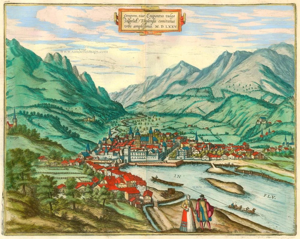
Oenipons, sive Enipontius vulgo Insspruck, Tirolensis Comitatus Urbs Amplissima MDLXXV 1575-1612
Innsbruck, by Braun and Hogenberg.
[Item number: 22402]

Gmunden 1596
Gmunden, by Georg Braun and Frans Hogenberg.
[Item number: 24185]
Prospectus amoeniss. vallis Oeniponticae una cum antro in altissima et praeruptissima rupe Imp. Maximiliani primi. [on sheet with:] Schlosberg. die Clause in Alpibus Tirolensibus. [and:] Monument. occursus Imp. Caroli V. et Ferdinandi fratis. 1596
The Innvalley; "Schlosberg" and a view of a monument for the emperor Carolus V, by Georg Braun and Frans Hogenberg.
[Item number: 24191]