
Salzburg by Georg Braun & Frans Hogenberg 1581

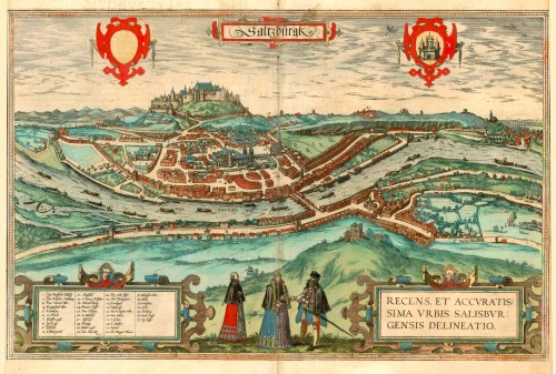

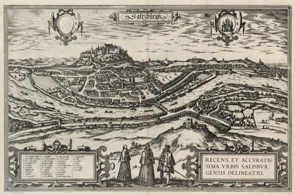
CARTOUCHE RIGHT: A new and faithful view of the city of Salzburg.
COMMENTARY BY BRAUN: "Salzburg is an exceedingly impressive city in Bavaria, encircled by substantial ring walls, towers and bastions, and very well appointed with public and private houses. Salzburg was formerly a royal seat and, during this time, furnished its churches very splendidly with marble and thus distinguished itself far above other cities. When Julius Caesar wished to defeat the Germans, he had a fortified castle built on top of the mountain to serve as a base for his soldiers, from which he wished to assist his allies. Hence, this castle was named Castrum Juvaviense, in German Helfenburg."
This second engraving of Salzburg in the Civitates returns to the exact origin of the first one. The impression of spaciousness does not correspond to the actual appearance of the city wedged between the Mönchsberg and the Kapuzinerberg. Braun refers to the legendary history of Salzburg, according to which Julius Caesar founded it. Salzburg was first mentioned in records in AD 755 as a trading settlement; in 996, it was granted the right to hold a market and mint its coins, and in 1287, it received its municipal charter. From the 16th century onwards, Salzburg played an essential role as a city of trade and as the residence of the prince-archbishops. The magnificent cathedral (15) seen here at the centre of the city dates from the time of Bishop Conrad III. Following a devastating fire in 1598, Archbishop Wolf Dietrich of Raitenau had 55 townhouses demolished to make space for a new cathedral and a grander street plan. The new cathedral in the Baroque style continues to leave its stamp on the face of Salzburg even today.
The engraving is made after a drawing by an unknown artist in 1553, which was used both for the woodcut in Münster's Cosmographia and the map of Austria in Ortelius's Theatrum Orbis Terrarum. (Taschen)
Braun G. & Hogenberg F. and the Civitates Orbis Terrarum.
The Civitates Orbis Terrarum, also known as the 'Braun & Hogenberg', is a six-volume town atlas and the most excellent book of town views and plans ever published: 363 engravings, sometimes beautifully coloured. It was one of the best-selling works in the last quarter of the 16th century. Georg Braun, a skilled writer, wrote the text accompanying the plans and views on the verso. Many plates were engraved after the original drawings of a professional artist, Joris Hoefnagel (1542-1600). The first volume was published in Latin in 1572 and the sixth in 1617. Frans Hogenberg, a talented engraver, created the tables for volumes I through IV, and Simon van den Neuwel made those for volumes V and VI. Other contributors were cartographers Daniel Freese and Heinrich Rantzau, who provided valuable geographical information. Works by Jacob van Deventer, Sebastian Münster, and Johannes Stumpf were also used as references. Translations appeared in German and French, making the atlas accessible to a wider audience.
Since its original publication of volume 1 in 1572, the Civitates Orbis Terrarum has left an indelible mark on the history of cartography. The first volume was followed by seven more editions in 1575, 1577, 1582, 1588, 1593, 1599, and 1612. Vol.2, initially released in 1575, saw subsequent editions in 1597 and 1612. The subsequent volumes, each a treasure trove of historical insights, graced the world in 1581, 1588, 1593, 1599, and 1606. The German translation of the first volume, a testament to its widespread appeal, debuted in 1574, followed by the French edition in 1575.
Several printers were involved: Theodor Graminaeus, Heinrich von Aich, Gottfried von Kempen, Johannis Sinniger, Bertram Buchholtz, and Peter von Brachel, all of whom worked in Cologne.
Georg Braun (1541-1622)
Georg Braun, the author of the text accompanying the plans and views in the Civitates Orbis Terrarum, was born in Cologne in 1541. After his studies in Cologne, he entered the Jesuit Order as a novice, indicating his commitment to learning and intellectual pursuits. In 1561, he obtained his bachelor's degree; in 1562, he received his Magister Artium, further demonstrating his academic achievements. Although he left the Jesuit Order, he continued his studies in theology, gaining a licentiate in theology. His theological background likely influenced the content and tone of the text in the Civitates Orbis Terrarum, adding a unique perspective to the work.
Frans Hogenberg (1535-1590)
Frans Hogenberg was a Flemish and German painter, engraver, and mapmaker. He was born in Mechelen as the son of Nicolaas Hogenberg.
By the end of the 1560s, Frans Hogenberg was employed upon Abraham Ortelius's Theatrum Orbis Terrarum, published in 1570; he is named an engraver of numerous maps. In 1568, he was banned from Antwerp by the Duke of Alva and travelled to London, where he stayed a few years before emigrating to Cologne. He immediately embarked on his two most important works, the Civitates, published in 1572 and the Geschichtsblätter, which appeared in several series from 1569 until about 1587.
Thanks to large-scale projects like the Geschichtsblätter and the Civitates, Hogenberg's social circumstances improved with each passing year. He died as a wealthy man in Cologne in 1590.
Saltzburgk, Recens et Accuratissima Urbis Salisburgensis Delineation.
Item Number: 25410 Authenticity Guarantee
Category: Antique maps > Europe > Austria
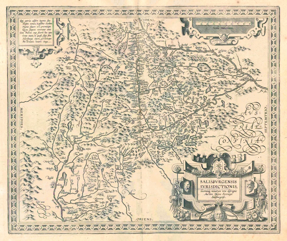
Salzburg by Georg Braun & Frans Hogenberg.
Title: Saltzburgk, Recens et Accuratissima Urbis Salisburgensis Delineation.
Date of the first edition: 1581.
Date of this map: 1581.
Copper engraving, printed on paper.
Image size: 330 x 505mm (12.99 x 19.88 inches).
Sheet size: 280 x 510mm (11.02 x 20.08 inches).
Verso: Latin text.
Condition: Original coloured, side margins trimmed to neatline.
Condition Rating: A.
From: Civitates Orbis Terrarum. . Liber tertius. Cologne, Gottfried von Kempen, 1581. (Van der Krogt 4, 41:1.3)
CARTOUCHE RIGHT: A new and faithful view of the city of Salzburg.
COMMENTARY BY BRAUN: "Salzburg is an exceedingly impressive city in Bavaria, encircled by substantial ring walls, towers and bastions, and very well appointed with public and private houses. Salzburg was formerly a royal seat and, during this time, furnished its churches very splendidly with marble and thus distinguished itself far above other cities. When Julius Caesar wished to defeat the Germans, he had a fortified castle built on top of the mountain to serve as a base for his soldiers, from which he wished to assist his allies. Hence, this castle was named Castrum Juvaviense, in German Helfenburg."
This second engraving of Salzburg in the Civitates returns to the exact origin of the first one. The impression of spaciousness does not correspond to the actual appearance of the city wedged between the Mönchsberg and the Kapuzinerberg. Braun refers to the legendary history of Salzburg, according to which Julius Caesar founded it. Salzburg was first mentioned in records in AD 755 as a trading settlement; in 996, it was granted the right to hold a market and mint its coins, and in 1287, it received its municipal charter. From the 16th century onwards, Salzburg played an essential role as a city of trade and as the residence of the prince-archbishops. The magnificent cathedral (15) seen here at the centre of the city dates from the time of Bishop Conrad III. Following a devastating fire in 1598, Archbishop Wolf Dietrich of Raitenau had 55 townhouses demolished to make space for a new cathedral and a grander street plan. The new cathedral in the Baroque style continues to leave its stamp on the face of Salzburg even today.
The engraving is made after a drawing by an unknown artist in 1553, which was used both for the woodcut in Münster's Cosmographia and the map of Austria in Ortelius's Theatrum Orbis Terrarum. (Taschen)
Braun G. & Hogenberg F. and the Civitates Orbis Terrarum.
The Civitates Orbis Terrarum, also known as the 'Braun & Hogenberg', is a six-volume town atlas and the most excellent book of town views and plans ever published: 363 engravings, sometimes beautifully coloured. It was one of the best-selling works in the last quarter of the 16th century. Georg Braun, a skilled writer, wrote the text accompanying the plans and views on the verso. Many plates were engraved after the original drawings of a professional artist, Joris Hoefnagel (1542-1600). The first volume was published in Latin in 1572 and the sixth in 1617. Frans Hogenberg, a talented engraver, created the tables for volumes I through IV, and Simon van den Neuwel made those for volumes V and VI. Other contributors were cartographers Daniel Freese and Heinrich Rantzau, who provided valuable geographical information. Works by Jacob van Deventer, Sebastian Münster, and Johannes Stumpf were also used as references. Translations appeared in German and French, making the atlas accessible to a wider audience.
Since its original publication of volume 1 in 1572, the Civitates Orbis Terrarum has left an indelible mark on the history of cartography. The first volume was followed by seven more editions in 1575, 1577, 1582, 1588, 1593, 1599, and 1612. Vol.2, initially released in 1575, saw subsequent editions in 1597 and 1612. The subsequent volumes, each a treasure trove of historical insights, graced the world in 1581, 1588, 1593, 1599, and 1606. The German translation of the first volume, a testament to its widespread appeal, debuted in 1574, followed by the French edition in 1575.
Several printers were involved: Theodor Graminaeus, Heinrich von Aich, Gottfried von Kempen, Johannis Sinniger, Bertram Buchholtz, and Peter von Brachel, all of whom worked in Cologne.
Georg Braun (1541-1622)
Georg Braun, the author of the text accompanying the plans and views in the Civitates Orbis Terrarum, was born in Cologne in 1541. After his studies in Cologne, he entered the Jesuit Order as a novice, indicating his commitment to learning and intellectual pursuits. In 1561, he obtained his bachelor's degree; in 1562, he received his Magister Artium, further demonstrating his academic achievements. Although he left the Jesuit Order, he continued his studies in theology, gaining a licentiate in theology. His theological background likely influenced the content and tone of the text in the Civitates Orbis Terrarum, adding a unique perspective to the work.
Frans Hogenberg (1535-1590)
Frans Hogenberg was a Flemish and German painter, engraver, and mapmaker. He was born in Mechelen as the son of Nicolaas Hogenberg.
By the end of the 1560s, Frans Hogenberg was employed upon Abraham Ortelius's Theatrum Orbis Terrarum, published in 1570; he is named an engraver of numerous maps. In 1568, he was banned from Antwerp by the Duke of Alva and travelled to London, where he stayed a few years before emigrating to Cologne. He immediately embarked on his two most important works, the Civitates, published in 1572 and the Geschichtsblätter, which appeared in several series from 1569 until about 1587.
Thanks to large-scale projects like the Geschichtsblätter and the Civitates, Hogenberg's social circumstances improved with each passing year. He died as a wealthy man in Cologne in 1590.
Related items
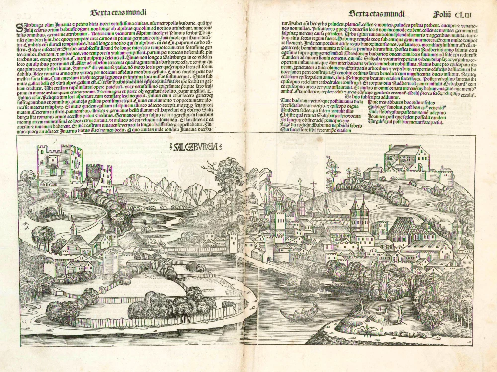
Salczburga 1493
Salzburg, by Hartmann Schedel.
[Item number: 5307]
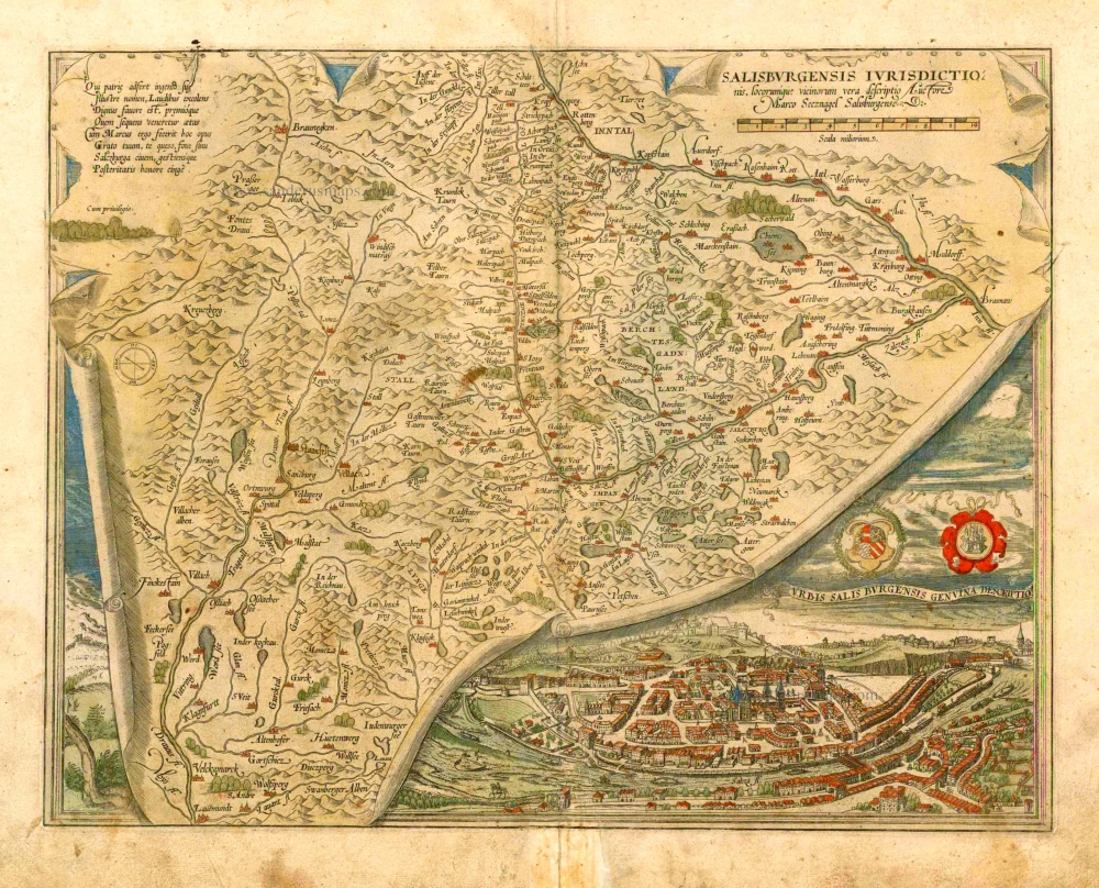
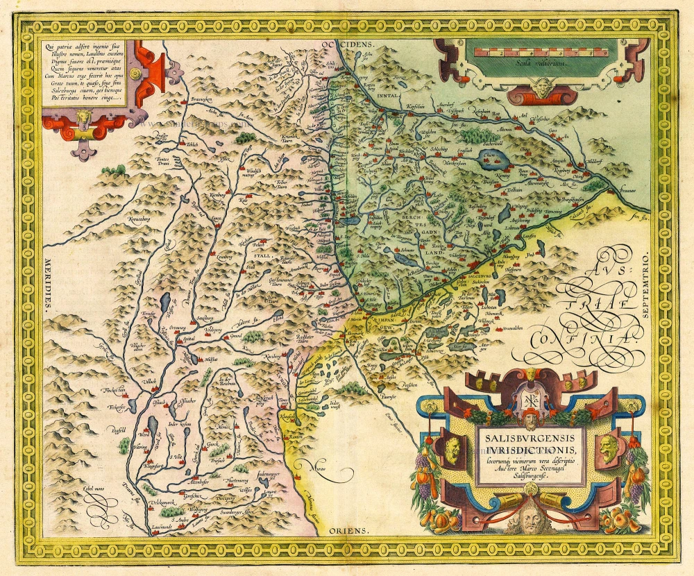
Salisburgensis Iurisdictionis, locorumque vicinorum vera descriptio. 1572
Austria, by Abraham Ortelius.
[Item number: 16002]
Salisburgensis Iurisdictionis, locorumq vicinorum vera descriptio. Auctore Marco Secznagel Salisburgense. 1612
Salzburg, by Ortelius A.
[Item number: 18677]
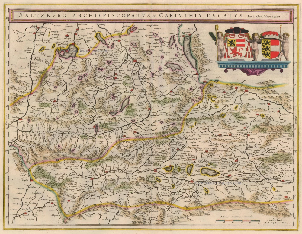
Salzburg Archiepiscopatus, et Carinthia Ducatus 1635
Old, antique map of Salzburg by Blaeu W. & J.
[Item number: 20389]
Saltzburgk, Recens et Accuratissima Urbis Salisburgensis Delineation. 1588
Salzburg, by Georg Braun and Frans Hogenberg.
[Item number: 21508]
Salisburgensis Iurisdictionis, locorumq vicinorum vera descriptio. Auctore Marco Secznagel Salisburgense 1612
Salzburg, by A. Ortelius.
[Item number: 23004]
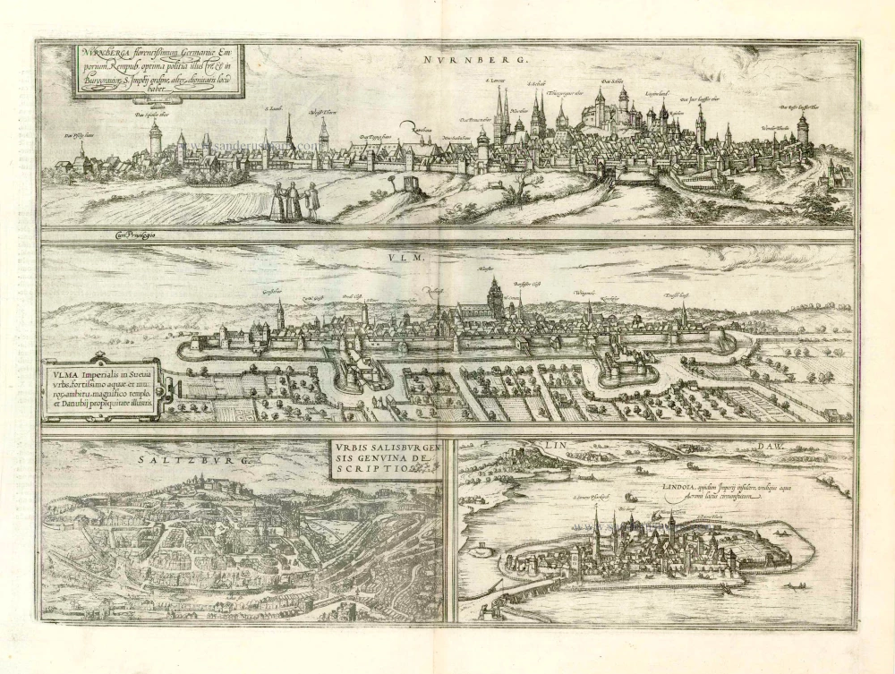
Nurnberga Florentissimum Germaniae Emporium, ... [on sheet with] Ulma Imperialis in Suevia [and] Saltzburg Urbis Salisburgensis Genvina Descriptio [and] Lindaw - Lindoia, Oppidum Imperij insulare, ... 1599
Nürnberg, Ulm, Salzburg, and Lindau, by Georg Braun and Frans Hogenberg.
[Item number: 23926]
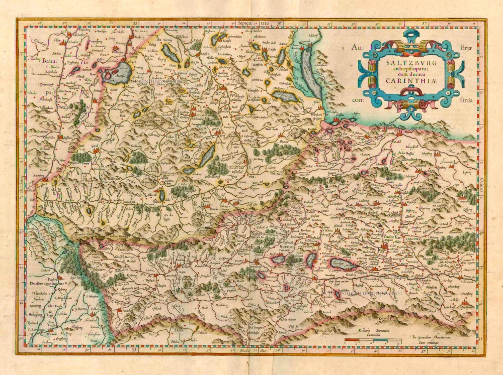
Saltzburg Archiepiscopatus cum Ducatu Carinthiae 1623
Salzburg - Kärnten, by G. Mercator.
[Item number: 24946]
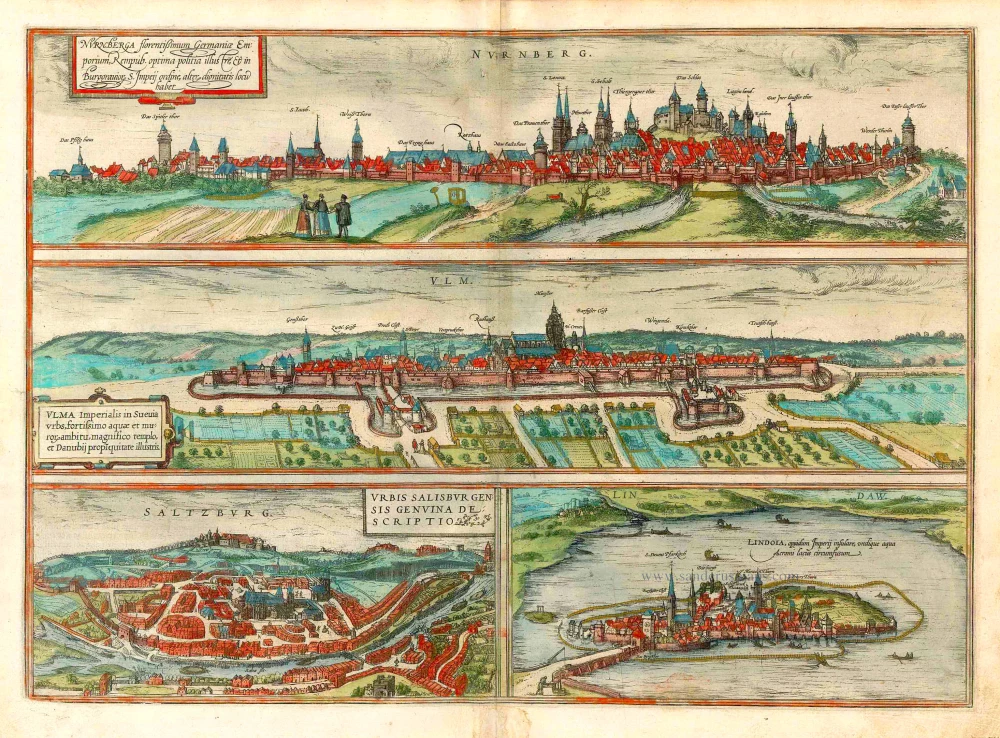
Nurnberga Florentissimum Germaniae Emporium, ... [on sheet with] Ulma Imperialis in Suevia [and] Saltzburg Urbis Salisburgensis Genvina Descriptio [and] Lindaw - Lindoia, Oppidum Imperij insulare, ... 1582
Nürnberg, Ulm, Salzburg, and Lindau by Georg Braun & Frans Hogenberg.
[Item number: 25485]