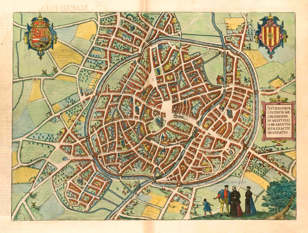
Lier, by Georg Braun and Frans Hogenberg. 1612
The item displayed on this page has been sold. However, we have a similar map in stock:
Lier, by Georg Braun and Frans Hogenberg. 1588
Lier - Lira, elegans et amoenum Brabantiae Opp:...
[Item number: 32427]
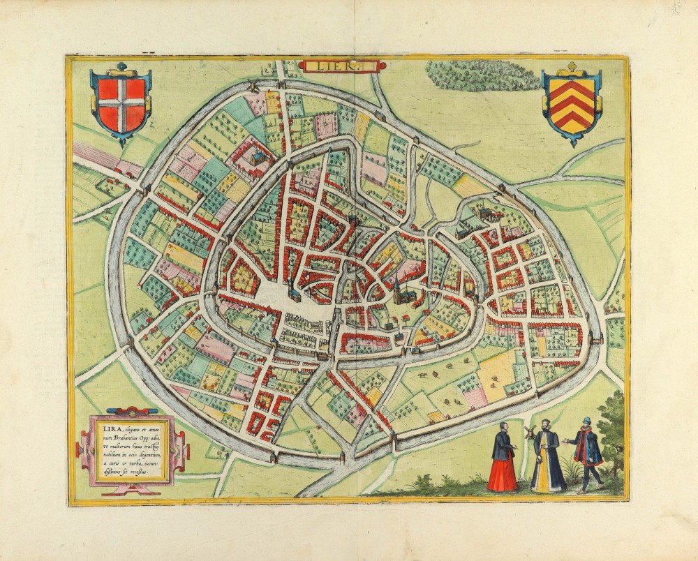
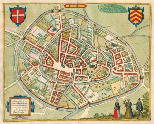
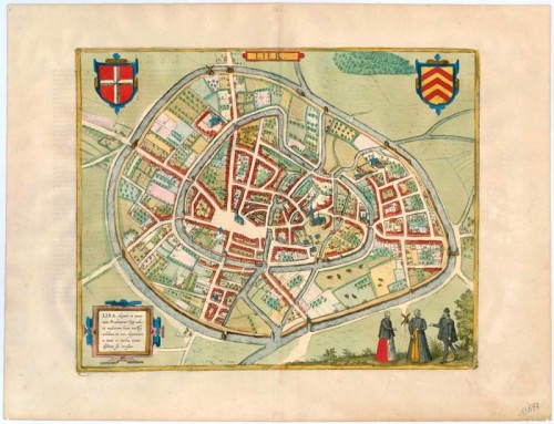
TRANSLATION OF CARTOUCHE TEXT: Lier, a Brabantian town so elegant and delightful that for many of the nobles in this region who can live a life of ease it is the most pleasant retreat from worries and commotion. COMMENTARY BY BRAUN (on verso): "Lier, an exceedingly handsome town located in the gentle countryside of Brabant, and belonging to the diocese of Antwerp, is well fortified by its natural position and by man-made buildings, and especially in these times of domestic unrest it has been reinforced with new bulwarks, bastions and moats, partly by the Spanish and partly by the others who have occupied it, in such a manner that it is deservedly known as one of the strongest cities in Brabant. [...] In our time it earns great wealth with wool and other crafts." This is a bird's-eye view from the south of the town, which has two moats. The inner moat encloses the medieval town. Standing out among the smaller buildings is the church of St Gummarus, a masterpiece of late Gothic Flemish architecture, and the town hall on the Grote Markt, with its Gothic belfry dating from 1369. This town is said to have begun as a hermit's cell that was established here by a Frankish knight, later known as St Gummarus, who is still the patron saint of the town today. In 1212 the town was granted a municipal charter and a wall was built around it shortly afterwards. Lier was expanded in 1287 and 1389. It owed its prosperity in large part to the livestock trade, especially with sheep, but also to the cloth industry. (Taschen)
Braun G. & Hogenberg F. and the Civitates Orbis Terrarum.
The Civitates Orbis Terrarum, also known as the 'Braun & Hogenberg', is a six-volume town atlas and the most excellent book of town views and plans ever published: 363 engravings, sometimes beautifully coloured. It was one of the best-selling works in the last quarter of the 16th century. Georg Braun, a skilled writer, wrote the text accompanying the plans and views on the verso. Many plates were engraved after the original drawings of a professional artist, Joris Hoefnagel (1542-1600). The first volume was published in Latin in 1572 and the sixth in 1617. Frans Hogenberg, a talented engraver, created the tables for volumes I through IV, and Simon van den Neuwel made those for volumes V and VI. Other contributors were cartographers Daniel Freese and Heinrich Rantzau, who provided valuable geographical information. Works by Jacob van Deventer, Sebastian Münster, and Johannes Stumpf were also used as references. Translations appeared in German and French, making the atlas accessible to a broader audience.
Since its original publication of volume 1 in 1572, the Civitates Orbis Terrarum has left an indelible mark on the history of cartography. Seven more editions followed the first volume in 1575, 1577, 1582, 1588, 1593, 1599, and 1612. Vol.2, initially released in 1575, saw subsequent editions in 1597 and 1612. The subsequent volumes, each a treasure trove of historical insights, graced the world in 1581, 1588, 1593, 1599, and 1606. The German translation of the first volume, a testament to its widespread appeal, debuted in 1574, followed by the French edition in 1575.
Several printers were involved: Theodor Graminaeus, Heinrich von Aich, Gottfried von Kempen, Johannis Sinniger, Bertram Buchholtz, and Peter von Brachel, all of whom worked in Cologne.
Georg Braun (1541-1622)
Georg Braun, the author of the text accompanying the plans and views in the Civitates Orbis Terrarum, was born in Cologne in 1541. After his studies in Cologne, he entered the Jesuit Order as a novice, indicating his commitment to learning and intellectual pursuits. In 1561, he obtained his bachelor's degree; in 1562, he received his Magister Artium, further demonstrating his academic achievements. Although he left the Jesuit Order, he continued his studies in theology, gaining a licentiate in theology. His theological background likely influenced the content and tone of the text in the Civitates Orbis Terrarum, adding a unique perspective to the work.
Frans Hogenberg (1535-1590)
Frans Hogenberg was a Flemish and German painter, engraver, and mapmaker. He was born in Mechelen as the son of Nicolaas Hogenberg.
By the end of the 1560s, Frans Hogenberg was employed upon Abraham Ortelius's Theatrum Orbis Terrarum, published in 1570; he is named an engraver of numerous maps. In 1568, he was banned from Antwerp by the Duke of Alva and travelled to London, where he stayed a few years before emigrating to Cologne. He immediately embarked on his two most important works, the Civitates, published in 1572 and the Geschichtsblätter, which appeared in several series from 1569 until about 1587.
Thanks to large-scale projects like the Geschichtsblätter and the Civitates, Hogenberg's social circumstances improved with each passing year. He died as a wealthy man in Cologne in 1590.
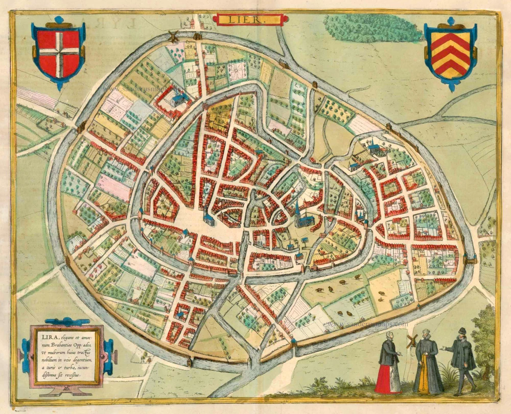
Lier - Lira, elegans et amoenum Brabantiae Opp: adeo, Ut multorum huius tractus nobilium in ocio degentium, a curise turba, iundissimus sit recessus.
Item Number: 13597 Authenticity Guarantee
Category: Antique maps > Europe > Belgium - Cities
Antique map - bird's-eye view plan of Lier by Braun and Hogenberg.
TRANSLATION OF CARTOUCHE TEXT: Lier, a Brabantian town so elegant and delightful that for many of the nobles in this region who can live a life of ease it is the most pleasant retreat from worries and commotion.
COMMENTARY BY BRAUN (on verso): "Lier, an exceedingly handsome town located in the gentle countryside of Brabant, and belonging to the diocese of Antwerp, is well fortified by its natural position and by man-made buildings, and especially in these times of domestic unrest it has been reinforced with new bulwarks, bastions and moats, partly by the Spanish and partly by the others who have occupied it, in such a manner that it is deservedly known as one of the strongest cities in Brabant. [...] In our time it earns great wealth with wool and other crafts."
This is a bird's-eye view from the south of the town, which has two moats. The inner moat encloses the medieval town. Standing out among the smaller buildings is the church of St Gummarus, a masterpiece of late Gothic Flemish architecture, and the town hall on the Grote Markt, with its Gothic belfry dating from 1369. This town is said to have begun as a hermit's cell that was established here by a Frankish knight, later known as St Gummarus, who is still the patron saint of the town today. In 1212 the town was granted a municipal charter and a wall was built around it shortly afterwards. Lier was expanded in 1287 and 1389. It owed its prosperity in large part to the livestock trade, especially with sheep, but also to the cloth industry. (Taschen)
Date of the first edition: 1588
Date of this map: 1612
Copper engraving
Size: 32 x 40cm (12.4 x 15.5 inches)
Verso text: Latin
Condition: Old coloured, excellent.
Condition Rating: A+
References: Van der Krogt 4, 2340; Taschen, Braun and Hogenberg, p.283.
From: Liber Quartus Urbium Praecipuarum Totius Mundi. Cologne,Petrus von Brachel, 1612. (Van der Krogt 4, 41:1.4(1612))
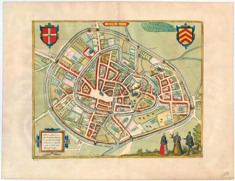
TRANSLATION OF CARTOUCHE TEXT: Lier, a Brabantian town so elegant and delightful that for many of the nobles in this region who can live a life of ease it is the most pleasant retreat from worries and commotion. COMMENTARY BY BRAUN (on verso): "Lier, an exceedingly handsome town located in the gentle countryside of Brabant, and belonging to the diocese of Antwerp, is well fortified by its natural position and by man-made buildings, and especially in these times of domestic unrest it has been reinforced with new bulwarks, bastions and moats, partly by the Spanish and partly by the others who have occupied it, in such a manner that it is deservedly known as one of the strongest cities in Brabant. [...] In our time it earns great wealth with wool and other crafts." This is a bird's-eye view from the south of the town, which has two moats. The inner moat encloses the medieval town. Standing out among the smaller buildings is the church of St Gummarus, a masterpiece of late Gothic Flemish architecture, and the town hall on the Grote Markt, with its Gothic belfry dating from 1369. This town is said to have begun as a hermit's cell that was established here by a Frankish knight, later known as St Gummarus, who is still the patron saint of the town today. In 1212 the town was granted a municipal charter and a wall was built around it shortly afterwards. Lier was expanded in 1287 and 1389. It owed its prosperity in large part to the livestock trade, especially with sheep, but also to the cloth industry. (Taschen)
Braun G. & Hogenberg F. and the Civitates Orbis Terrarum.
The Civitates Orbis Terrarum, also known as the 'Braun & Hogenberg', is a six-volume town atlas and the most excellent book of town views and plans ever published: 363 engravings, sometimes beautifully coloured. It was one of the best-selling works in the last quarter of the 16th century. Georg Braun, a skilled writer, wrote the text accompanying the plans and views on the verso. Many plates were engraved after the original drawings of a professional artist, Joris Hoefnagel (1542-1600). The first volume was published in Latin in 1572 and the sixth in 1617. Frans Hogenberg, a talented engraver, created the tables for volumes I through IV, and Simon van den Neuwel made those for volumes V and VI. Other contributors were cartographers Daniel Freese and Heinrich Rantzau, who provided valuable geographical information. Works by Jacob van Deventer, Sebastian Münster, and Johannes Stumpf were also used as references. Translations appeared in German and French, making the atlas accessible to a broader audience.
Since its original publication of volume 1 in 1572, the Civitates Orbis Terrarum has left an indelible mark on the history of cartography. Seven more editions followed the first volume in 1575, 1577, 1582, 1588, 1593, 1599, and 1612. Vol.2, initially released in 1575, saw subsequent editions in 1597 and 1612. The subsequent volumes, each a treasure trove of historical insights, graced the world in 1581, 1588, 1593, 1599, and 1606. The German translation of the first volume, a testament to its widespread appeal, debuted in 1574, followed by the French edition in 1575.
Several printers were involved: Theodor Graminaeus, Heinrich von Aich, Gottfried von Kempen, Johannis Sinniger, Bertram Buchholtz, and Peter von Brachel, all of whom worked in Cologne.
Georg Braun (1541-1622)
Georg Braun, the author of the text accompanying the plans and views in the Civitates Orbis Terrarum, was born in Cologne in 1541. After his studies in Cologne, he entered the Jesuit Order as a novice, indicating his commitment to learning and intellectual pursuits. In 1561, he obtained his bachelor's degree; in 1562, he received his Magister Artium, further demonstrating his academic achievements. Although he left the Jesuit Order, he continued his studies in theology, gaining a licentiate in theology. His theological background likely influenced the content and tone of the text in the Civitates Orbis Terrarum, adding a unique perspective to the work.
Frans Hogenberg (1535-1590)
Frans Hogenberg was a Flemish and German painter, engraver, and mapmaker. He was born in Mechelen as the son of Nicolaas Hogenberg.
By the end of the 1560s, Frans Hogenberg was employed upon Abraham Ortelius's Theatrum Orbis Terrarum, published in 1570; he is named an engraver of numerous maps. In 1568, he was banned from Antwerp by the Duke of Alva and travelled to London, where he stayed a few years before emigrating to Cologne. He immediately embarked on his two most important works, the Civitates, published in 1572 and the Geschichtsblätter, which appeared in several series from 1569 until about 1587.
Thanks to large-scale projects like the Geschichtsblätter and the Civitates, Hogenberg's social circumstances improved with each passing year. He died as a wealthy man in Cologne in 1590.