
Tienen by Georg Braun & Frans Hogenberg. 1623


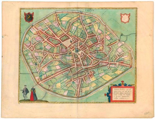

TRANSLATION OF CARTOUCHE TEXT: Tienen, Brabantine town on the Geta, from whence comes much cheese, which is named after it. There is also a church of St Germain and a college of canons here.
COMMENTARY BY BRAUN: "That Tienen was once a large and important trade town is not only related in all the chronicles but is evident, too, from the buildings that can still be viewed today: the city was namely enlarged and encircled with new walls four times. Before its decline, as a result of which 's-Hertogenbosch experienced an economic upswing, it was the fourth-largest city in Brabant, but in the course of fierce wars between the Brabantines, the French and the Eburones, it was captured and destroyed more than once, so that some parts of the town are uninhabited."
The plan view from the southwest shows the formerly more populous Belgian town lying within extensive walls encompassing farmlands and fields. The large church of Sint-Germanus is on the open ground on the old cattle market in the city's centre. Behind it to the left is the Grote Markt, part of which lies on drained marshland, whence the name of the Gothic church on the square's east side: Onze-Lieve-Vrouw-ten-Poel. Tienen was probably founded around AD 800 by the Holstein branch of the Thienen-Adlerflycht dynasty on a site already inhabited in Celtic times. In the late Middle Ages, the town lived from cloth weaving, caught up in wars in the 16th century. However, it rapidly declined, and 1635 was almost destroyed. (Taschen)
Tienen - Tiena, Brabantiae Opp: ad amnem Geta, ...
Item Number: 23305 Authenticity Guarantee
Category: Antique maps > Europe > Belgium - Cities
Old, antique bird’s-eye view plan of Tienen by Georg Braun & Frans Hogenberg.
Title: Tienen - Tiena, Brabantiae Opp: ad amnem Geta, ...
Cartographer: Jacob van Deventer.
Date of the first edition: 1581.
Date of this map: 1623.
Copper engraving, printed on paper.
Image size: 340 x 420mm (13.39 x 16.54 inches).
Sheet size: 410 x 540mm (16.14 x 21.26 inches).
Verso: Latin text.
Condition: Superb old colour, excellent.
Condition Rating: A+.
From: Civitates Orbis Terrarum. - Urbium Praeciuarum Totius Mundi Liber Terius. Cologne, Petrus von Brachel, 1623. (Van der Krogt 4, 41:1.3)
TRANSLATION OF CARTOUCHE TEXT: Tienen, Brabantine town on the Geta, from whence comes much cheese, which is named after it. There is also a church of St Germain and a college of canons here.
COMMENTARY BY BRAUN: "That Tienen was once a large and important trade town is not only related in all the chronicles but is evident, too, from the buildings that can still be viewed today: the city was namely enlarged and encircled with new walls four times. Before its decline, as a result of which 's-Hertogenbosch experienced an economic upswing, it was the fourth-largest city in Brabant, but in the course of fierce wars between the Brabantines, the French and the Eburones, it was captured and destroyed more than once, so that some parts of the town are uninhabited."
The plan view from the southwest shows the formerly more populous Belgian town lying within extensive walls encompassing farmlands and fields. The large church of Sint-Germanus is on the open ground on the old cattle market in the city's centre. Behind it to the left is the Grote Markt, part of which lies on drained marshland, whence the name of the Gothic church on the square's east side: Onze-Lieve-Vrouw-ten-Poel. Tienen was probably founded around AD 800 by the Holstein branch of the Thienen-Adlerflycht dynasty on a site already inhabited in Celtic times. In the late Middle Ages, the town lived from cloth weaving, caught up in wars in the 16th century. However, it rapidly declined, and 1635 was almost destroyed. (Taschen)
Related items

Tienen. 1616
Tienen by Ludovico Guicciardini.
[Item number: 16740]
Tienen - Tiena, Brabantiae Opp: ad amnem Geta, ... 1581-88
Tienen, by Georg Braun and Frans Hogenberg.
[Item number: 22196]

Tienen. 1656
Tienen, by Visscher N. - Schut P.H.
[Item number: 25373]

Thienen. 1652
Tienen by Joan Blaeu.
[Item number: 29543]

Tienen. 1612
Tienen by Ludovico Guicciardini.
[Item number: 32855]