
Tienen, by Georg Braun and Frans Hogenberg. 1581-88
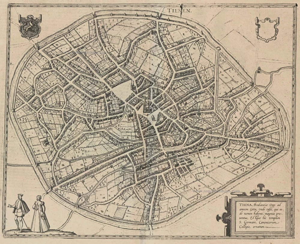
TRANSLATION OF CARTOUCHE TEXT: Tienen, Brabantine town on the Geta, from whence comes much cheese, which is named after it. There is also a church of St Germain and a college of canons here.
COMMENTARY BY BRAUN: "That Tienen was once a large and important trade town is not only related in all the chronicles but is evident, too, from the buildings that can still be viewed today: the city was namely enlarged and encircled with new walls four times. Before its decline, as a result of which 's-Hertogenbosch experienced an economic upswing, it was the fourth-largest city in Brabant, but in the course of fierce wars between the Brabantines, the French and the Eburones, it was captured and destroyed more than once, so that some parts of the town are uninhabited."
The plan view from the southwest shows the formerly more populous Belgian town lying within extensive walls encompassing farmlands and fields. On the open ground on the old cattle market, at the centre of the town, rises the large church of Sint-Germanus. Behind it to the left is the Grote Markt, part of which lies on drained marshland, whence the name of the Gothic church on the square's east side: Onze-Lieve-Vrouw-ten-Poel. Tienen was probably founded around AD 800 by the Holstein branch of the Thienen-Adlerflycht dynasty on a site already inhabited in Celtic times. In the late Middle Ages, the town lived from cloth weaving; caught up in wars in the 16th century, however, it rapidly declined and in 1635 was almost destroyed. (Taschen)
Braun G. & Hogenberg F. and the Civitates Orbis Terrarum.
The Civitates Orbis Terrarum, also known as the 'Braun & Hogenberg', is a six-volume town atlas and the most excellent book of town views and plans ever published: 363 engravings, sometimes beautifully coloured. It was one of the best-selling works in the last quarter of the 16th century. Georg Braun, a skilled writer, wrote the text accompanying the plans and views on the verso. Many plates were engraved after the original drawings of a professional artist, Joris Hoefnagel (1542-1600). The first volume was published in Latin in 1572 and the sixth in 1617. Frans Hogenberg, a talented engraver, created the tables for volumes I through IV, and Simon van den Neuwel made those for volumes V and VI. Other contributors were cartographers Daniel Freese and Heinrich Rantzau, who provided valuable geographical information. Works by Jacob van Deventer, Sebastian Münster, and Johannes Stumpf were also used as references. Translations appeared in German and French, making the atlas accessible to a broader audience.
Since its original publication of volume 1 in 1572, the Civitates Orbis Terrarum has left an indelible mark on the history of cartography. Seven more editions followed the first volume in 1575, 1577, 1582, 1588, 1593, 1599, and 1612. Vol.2, initially released in 1575, saw subsequent editions in 1597 and 1612. The subsequent volumes, each a treasure trove of historical insights, graced the world in 1581, 1588, 1593, 1599, and 1606. The German translation of the first volume, a testament to its widespread appeal, debuted in 1574, followed by the French edition in 1575.
Several printers were involved: Theodor Graminaeus, Heinrich von Aich, Gottfried von Kempen, Johannis Sinniger, Bertram Buchholtz, and Peter von Brachel, all of whom worked in Cologne.
Georg Braun (1541-1622)
Georg Braun, the author of the text accompanying the plans and views in the Civitates Orbis Terrarum, was born in Cologne in 1541. After his studies in Cologne, he entered the Jesuit Order as a novice, indicating his commitment to learning and intellectual pursuits. In 1561, he obtained his bachelor's degree; in 1562, he received his Magister Artium, further demonstrating his academic achievements. Although he left the Jesuit Order, he continued his studies in theology, gaining a licentiate in theology. His theological background likely influenced the content and tone of the text in the Civitates Orbis Terrarum, adding a unique perspective to the work.
Frans Hogenberg (1535-1590)
Frans Hogenberg was a Flemish and German painter, engraver, and mapmaker. He was born in Mechelen as the son of Nicolaas Hogenberg.
By the end of the 1560s, Frans Hogenberg was employed upon Abraham Ortelius's Theatrum Orbis Terrarum, published in 1570; he is named an engraver of numerous maps. In 1568, he was banned from Antwerp by the Duke of Alva and travelled to London, where he stayed a few years before emigrating to Cologne. He immediately embarked on his two most important works, the Civitates, published in 1572 and the Geschichtsblätter, which appeared in several series from 1569 until about 1587.
Thanks to large-scale projects like the Geschichtsblätter and the Civitates, Hogenberg's social circumstances improved with each passing year. He died as a wealthy man in Cologne in 1590.
Tienen - Tiena, Brabantiae Opp: ad amnem Geta, ...
Item Number: 22196 Authenticity Guarantee
Category: Antique maps > Europe > Belgium - Cities
Old, antique bird’s-eye view plan of Tienen, by Georg Braun and Frans Hogenberg.
Title: Tienen - Tiena, Brabantiae Opp: ad amnem Geta, ...
Date: 1581-88.
Copper engraving, printed on paper.
Size (not including margins): 340 x 420mm (13.39 x 16.54 inches).
Verso: Latin text.
Condition: Uncoloured, lower centrefold split reinforced.
Condition Rating: A.
From: Civitates Orbis Terrarum. . Liber tertius. Köln, G. Kempen, 1581-88. (Koeman, B&H3)
TRANSLATION OF CARTOUCHE TEXT: Tienen, Brabantine town on the Geta, from whence comes much cheese, which is named after it. There is also a church of St Germain and a college of canons here.
COMMENTARY BY BRAUN: "That Tienen was once a large and important trade town is not only related in all the chronicles but is evident, too, from the buildings that can still be viewed today: the city was namely enlarged and encircled with new walls four times. Before its decline, as a result of which 's-Hertogenbosch experienced an economic upswing, it was the fourth-largest city in Brabant, but in the course of fierce wars between the Brabantines, the French and the Eburones, it was captured and destroyed more than once, so that some parts of the town are uninhabited."
The plan view from the southwest shows the formerly more populous Belgian town lying within extensive walls encompassing farmlands and fields. On the open ground on the old cattle market, at the centre of the town, rises the large church of Sint-Germanus. Behind it to the left is the Grote Markt, part of which lies on drained marshland, whence the name of the Gothic church on the square's east side: Onze-Lieve-Vrouw-ten-Poel. Tienen was probably founded around AD 800 by the Holstein branch of the Thienen-Adlerflycht dynasty on a site already inhabited in Celtic times. In the late Middle Ages, the town lived from cloth weaving; caught up in wars in the 16th century, however, it rapidly declined and in 1635 was almost destroyed. (Taschen)
Braun G. & Hogenberg F. and the Civitates Orbis Terrarum.
The Civitates Orbis Terrarum, also known as the 'Braun & Hogenberg', is a six-volume town atlas and the most excellent book of town views and plans ever published: 363 engravings, sometimes beautifully coloured. It was one of the best-selling works in the last quarter of the 16th century. Georg Braun, a skilled writer, wrote the text accompanying the plans and views on the verso. Many plates were engraved after the original drawings of a professional artist, Joris Hoefnagel (1542-1600). The first volume was published in Latin in 1572 and the sixth in 1617. Frans Hogenberg, a talented engraver, created the tables for volumes I through IV, and Simon van den Neuwel made those for volumes V and VI. Other contributors were cartographers Daniel Freese and Heinrich Rantzau, who provided valuable geographical information. Works by Jacob van Deventer, Sebastian Münster, and Johannes Stumpf were also used as references. Translations appeared in German and French, making the atlas accessible to a broader audience.
Since its original publication of volume 1 in 1572, the Civitates Orbis Terrarum has left an indelible mark on the history of cartography. Seven more editions followed the first volume in 1575, 1577, 1582, 1588, 1593, 1599, and 1612. Vol.2, initially released in 1575, saw subsequent editions in 1597 and 1612. The subsequent volumes, each a treasure trove of historical insights, graced the world in 1581, 1588, 1593, 1599, and 1606. The German translation of the first volume, a testament to its widespread appeal, debuted in 1574, followed by the French edition in 1575.
Several printers were involved: Theodor Graminaeus, Heinrich von Aich, Gottfried von Kempen, Johannis Sinniger, Bertram Buchholtz, and Peter von Brachel, all of whom worked in Cologne.
Georg Braun (1541-1622)
Georg Braun, the author of the text accompanying the plans and views in the Civitates Orbis Terrarum, was born in Cologne in 1541. After his studies in Cologne, he entered the Jesuit Order as a novice, indicating his commitment to learning and intellectual pursuits. In 1561, he obtained his bachelor's degree; in 1562, he received his Magister Artium, further demonstrating his academic achievements. Although he left the Jesuit Order, he continued his studies in theology, gaining a licentiate in theology. His theological background likely influenced the content and tone of the text in the Civitates Orbis Terrarum, adding a unique perspective to the work.
Frans Hogenberg (1535-1590)
Frans Hogenberg was a Flemish and German painter, engraver, and mapmaker. He was born in Mechelen as the son of Nicolaas Hogenberg.
By the end of the 1560s, Frans Hogenberg was employed upon Abraham Ortelius's Theatrum Orbis Terrarum, published in 1570; he is named an engraver of numerous maps. In 1568, he was banned from Antwerp by the Duke of Alva and travelled to London, where he stayed a few years before emigrating to Cologne. He immediately embarked on his two most important works, the Civitates, published in 1572 and the Geschichtsblätter, which appeared in several series from 1569 until about 1587.
Thanks to large-scale projects like the Geschichtsblätter and the Civitates, Hogenberg's social circumstances improved with each passing year. He died as a wealthy man in Cologne in 1590.
Related items

Tienen. 1616
Tienen by Ludovico Guicciardini.
[Item number: 16740]

Mechelen - Nitidissimae Civitatis Mechlineensis in meditullio Brabantiae sitae, exactis: delineatio 1581-88
Mechelen, by Braun & Hogenberg.
[Item number: 18002]

Tienen - Tiena, Brabantiae Opp: ad amnem Geta, ... 1623
Tienen by Georg Braun & Frans Hogenberg.
[Item number: 23305]

Tienen. 1656
Tienen, by Visscher N. - Schut P.H.
[Item number: 25373]

Thienen. 1652
Tienen by Joan Blaeu.
[Item number: 29543]

Tienen. 1612
Tienen by Ludovico Guicciardini.
[Item number: 32855]