
London by Georg Braun & Frans Hogenberg 1593

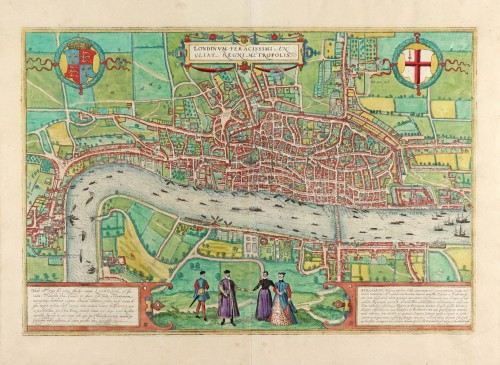
TRANSLATION OF CAPTION: London is an exceptionally fast-growing English royal city.
CARTOUCHE LEFT: London, king of all the cities in England, is situated on the River Thames. Caesar, so it is said, called it Trinobantum. It is famed amongst many peoples for its commerce, adorned with houses and churches, distinguished by fortifications, famed for men of all arts and sciences, and its wealth in all things. Goods from all over the world are brought hither on her Thames, as it is navigable for 60,000 paces at high tide.
CARTOUCHE RIGHT: STILLIARDS or, in German, Hanse, a confederation of many cities and communities, established for safe trading on land and sea, lastly for tranquillity and peace in public affairs and the honourable education of the young. Most of all, they granted privileges and concessions by the rulers of England, France, Denmark, Great Moscow, Flanders and Brabant. It has four markets, called counting houses by some, where the merchants reside and conduct their business. One of these is salient in London for domestic trade, namely the Teutonic Guildhall, or Stilliard.
COMMENTARY BY BRAUN: "Although this city is already huge, it still has beautiful suburbs and a magnificent castle called the Tower. It is embellished to the best possible degree with splendid buildings and churches and possesses 120 parish churches. [...] The fame of all other cities is utterly exceeded by London [...]. It is a powerful city of commerce [...] furnished with abundance and wealth. The Thames brings riches worldwide since even large vessels can sail into the city on the tide. Here, the kings are crowned and installed in office; here, too, the parliament is held by 24 citizens, called aldermen, according to old English custom."
The first volume of the Civitates opens with this magnificent bird's-eye view plan of London seen from a bird's-eye perspective. It reproduces the city as it looked around 1550, as can be seen, e.g., St Paul's cathedral is depicted with a tall spire, which was destroyed in 1561. The royal barge can be seen on the Thames in the centre of the picture. Establishing itself on the river's south bank is the new Southwark district, which would officially become part of London after 1550: visible near the centrefold are the theatres, or more specifically arenas, in which bull and bear fights were staged. Shown on a magnified scale in the foreground are four people in contemporary dress standing on a fictive grassy hillock, as it were, enjoying an idealised view of the city. They embody the English fashion of the first half of the 16th century: the men and women, although they belong to different social classes, continue to wear high, closed ruffs, which changed towards the end of the century. The representation derives from a lost 15-part city plan, of which today only three plates survive. The Hanseatic League probably commissioned the original plan, which is indicated by the emphasis on describing the Hansa trading centre as "Steelyard" (Stilliard), and the praise meted out to the Hansa for its special status in worldwide trade. (Taschen)
Braun G. & Hogenberg F. and the Civitates Orbis Terrarum.
The Civitates Orbis Terrarum, also known as the 'Braun & Hogenberg', is a six-volume town atlas and the most excellent book of town views and plans ever published: 363 engravings, sometimes beautifully coloured. It was one of the best-selling works in the last quarter of the 16th century. Georg Braun, a skilled writer, wrote the text accompanying the plans and views on the verso. Many plates were engraved after the original drawings of a professional artist, Joris Hoefnagel (1542-1600). The first volume was published in Latin in 1572 and the sixth in 1617. Frans Hogenberg, a talented engraver, created the tables for volumes I through IV, and Simon van den Neuwel made those for volumes V and VI. Other contributors were cartographers Daniel Freese and Heinrich Rantzau, who provided valuable geographical information. Works by Jacob van Deventer, Sebastian Münster, and Johannes Stumpf were also used as references. Translations appeared in German and French, making the atlas accessible to a broader audience.
Since its original publication of volume 1 in 1572, the Civitates Orbis Terrarum has left an indelible mark on the history of cartography. Seven more editions followed the first volume in 1575, 1577, 1582, 1588, 1593, 1599, and 1612. Vol.2, initially released in 1575, saw subsequent editions in 1597 and 1612. The subsequent volumes, each a treasure trove of historical insights, graced the world in 1581, 1588, 1593, 1599, and 1606. The German translation of the first volume, a testament to its widespread appeal, debuted in 1574, followed by the French edition in 1575.
Several printers were involved: Theodor Graminaeus, Heinrich von Aich, Gottfried von Kempen, Johannis Sinniger, Bertram Buchholtz, and Peter von Brachel, all of whom worked in Cologne.
Georg Braun (1541-1622)
Georg Braun, the author of the text accompanying the plans and views in the Civitates Orbis Terrarum, was born in Cologne in 1541. After his studies in Cologne, he entered the Jesuit Order as a novice, indicating his commitment to learning and intellectual pursuits. In 1561, he obtained his bachelor's degree; in 1562, he received his Magister Artium, further demonstrating his academic achievements. Although he left the Jesuit Order, he continued his studies in theology, gaining a licentiate in theology. His theological background likely influenced the content and tone of the text in the Civitates Orbis Terrarum, adding a unique perspective to the work.
Frans Hogenberg (1535-1590)
Frans Hogenberg was a Flemish and German painter, engraver, and mapmaker. He was born in Mechelen as the son of Nicolaas Hogenberg.
By the end of the 1560s, Frans Hogenberg was employed upon Abraham Ortelius's Theatrum Orbis Terrarum, published in 1570; he is named an engraver of numerous maps. In 1568, he was banned from Antwerp by the Duke of Alva and travelled to London, where he stayed a few years before emigrating to Cologne. He immediately embarked on his two most important works, the Civitates, published in 1572 and the Geschichtsblätter, which appeared in several series from 1569 until about 1587.
Thanks to large-scale projects like the Geschichtsblätter and the Civitates, Hogenberg's social circumstances improved with each passing year. He died as a wealthy man in Cologne in 1590.
Londinum Feracissimi Angliae Regni Metropolis.
Item Number: 30542 Authenticity Guarantee
Category: Antique maps > Europe > British Isles - Cities
London by Georg Braun & Frans Hogenberg.
Title: Londinum Feracissimi Angliae Regni Metropolis.
Cum Privilegio.
Date of the first edition: 1572.
Date of this map: 1593.
Copper engraving, printed on paper.
Image size: 330 x 485mm (12.99 x 19.09 inches).
Sheet size: 415 x 540mm (16.34 x 21.26 inches).
Verso: French text.
Condition: Original coloured, excellent.
Condition Rating: A+.
From: Braun G. & Hogenberg F. Théatre des Principales Villes de Tout l'Univers. Second Volume. Cologne, Georges Brun, s.d. [1593]. (Van der Krogt 4-1, 41:3.2)
TRANSLATION OF CAPTION: London is an exceptionally fast-growing English royal city.
CARTOUCHE LEFT: London, king of all the cities in England, is situated on the River Thames. Caesar, so it is said, called it Trinobantum. It is famed amongst many peoples for its commerce, adorned with houses and churches, distinguished by fortifications, famed for men of all arts and sciences, and its wealth in all things. Goods from all over the world are brought hither on her Thames, as it is navigable for 60,000 paces at high tide.
CARTOUCHE RIGHT: STILLIARDS or, in German, Hanse, a confederation of many cities and communities, established for safe trading on land and sea, lastly for tranquillity and peace in public affairs and the honourable education of the young. Most of all, they granted privileges and concessions by the rulers of England, France, Denmark, Great Moscow, Flanders and Brabant. It has four markets, called counting houses by some, where the merchants reside and conduct their business. One of these is salient in London for domestic trade, namely the Teutonic Guildhall, or Stilliard.
COMMENTARY BY BRAUN: "Although this city is already huge, it still has beautiful suburbs and a magnificent castle called the Tower. It is embellished to the best possible degree with splendid buildings and churches and possesses 120 parish churches. [...] The fame of all other cities is utterly exceeded by London [...]. It is a powerful city of commerce [...] furnished with abundance and wealth. The Thames brings riches worldwide since even large vessels can sail into the city on the tide. Here, the kings are crowned and installed in office; here, too, the parliament is held by 24 citizens, called aldermen, according to old English custom."
The first volume of the Civitates opens with this magnificent bird's-eye view plan of London seen from a bird's-eye perspective. It reproduces the city as it looked around 1550, as can be seen, e.g., St Paul's cathedral is depicted with a tall spire, which was destroyed in 1561. The royal barge can be seen on the Thames in the centre of the picture. Establishing itself on the river's south bank is the new Southwark district, which would officially become part of London after 1550: visible near the centrefold are the theatres, or more specifically arenas, in which bull and bear fights were staged. Shown on a magnified scale in the foreground are four people in contemporary dress standing on a fictive grassy hillock, as it were, enjoying an idealised view of the city. They embody the English fashion of the first half of the 16th century: the men and women, although they belong to different social classes, continue to wear high, closed ruffs, which changed towards the end of the century. The representation derives from a lost 15-part city plan, of which today only three plates survive. The Hanseatic League probably commissioned the original plan, which is indicated by the emphasis on describing the Hansa trading centre as "Steelyard" (Stilliard), and the praise meted out to the Hansa for its special status in worldwide trade. (Taschen)
Braun G. & Hogenberg F. and the Civitates Orbis Terrarum.
The Civitates Orbis Terrarum, also known as the 'Braun & Hogenberg', is a six-volume town atlas and the most excellent book of town views and plans ever published: 363 engravings, sometimes beautifully coloured. It was one of the best-selling works in the last quarter of the 16th century. Georg Braun, a skilled writer, wrote the text accompanying the plans and views on the verso. Many plates were engraved after the original drawings of a professional artist, Joris Hoefnagel (1542-1600). The first volume was published in Latin in 1572 and the sixth in 1617. Frans Hogenberg, a talented engraver, created the tables for volumes I through IV, and Simon van den Neuwel made those for volumes V and VI. Other contributors were cartographers Daniel Freese and Heinrich Rantzau, who provided valuable geographical information. Works by Jacob van Deventer, Sebastian Münster, and Johannes Stumpf were also used as references. Translations appeared in German and French, making the atlas accessible to a broader audience.
Since its original publication of volume 1 in 1572, the Civitates Orbis Terrarum has left an indelible mark on the history of cartography. Seven more editions followed the first volume in 1575, 1577, 1582, 1588, 1593, 1599, and 1612. Vol.2, initially released in 1575, saw subsequent editions in 1597 and 1612. The subsequent volumes, each a treasure trove of historical insights, graced the world in 1581, 1588, 1593, 1599, and 1606. The German translation of the first volume, a testament to its widespread appeal, debuted in 1574, followed by the French edition in 1575.
Several printers were involved: Theodor Graminaeus, Heinrich von Aich, Gottfried von Kempen, Johannis Sinniger, Bertram Buchholtz, and Peter von Brachel, all of whom worked in Cologne.
Georg Braun (1541-1622)
Georg Braun, the author of the text accompanying the plans and views in the Civitates Orbis Terrarum, was born in Cologne in 1541. After his studies in Cologne, he entered the Jesuit Order as a novice, indicating his commitment to learning and intellectual pursuits. In 1561, he obtained his bachelor's degree; in 1562, he received his Magister Artium, further demonstrating his academic achievements. Although he left the Jesuit Order, he continued his studies in theology, gaining a licentiate in theology. His theological background likely influenced the content and tone of the text in the Civitates Orbis Terrarum, adding a unique perspective to the work.
Frans Hogenberg (1535-1590)
Frans Hogenberg was a Flemish and German painter, engraver, and mapmaker. He was born in Mechelen as the son of Nicolaas Hogenberg.
By the end of the 1560s, Frans Hogenberg was employed upon Abraham Ortelius's Theatrum Orbis Terrarum, published in 1570; he is named an engraver of numerous maps. In 1568, he was banned from Antwerp by the Duke of Alva and travelled to London, where he stayed a few years before emigrating to Cologne. He immediately embarked on his two most important works, the Civitates, published in 1572 and the Geschichtsblätter, which appeared in several series from 1569 until about 1587.
Thanks to large-scale projects like the Geschichtsblätter and the Civitates, Hogenberg's social circumstances improved with each passing year. He died as a wealthy man in Cologne in 1590.
Related items
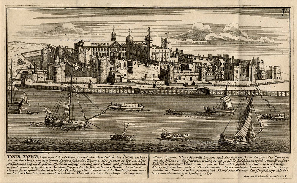
Tour Towr, heist eigentlich ein Thurm, es wird aber absonderlich das Castell zu Londen an der Temse, von dem mitten darinnen stehenden Thurms, also gennet, ... 1720
The Tower in London, by Gabriel Bodenehr.
[Item number: 13435]
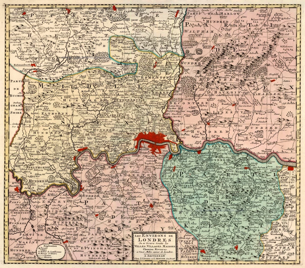
Les Environs de Londres Ou se trouve toutte les Villes, Villages, Maisons, Chemins, Rivières, à Vinct Milles autour de Londres. 1721-41
London, by Covens & Mortier.
[Item number: 23728]
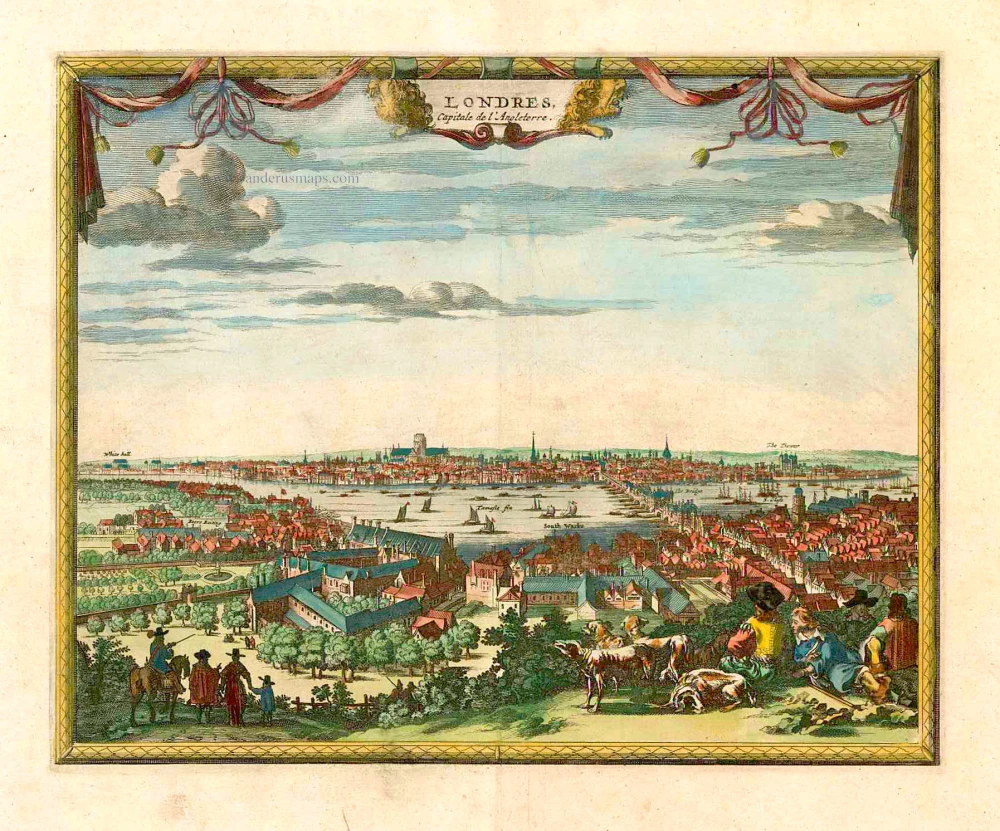
Londres Capitale de l'Angleterre. c. 1715
London, by Pieter van der Aa.
[Item number: 26854]

Londinum, Feracissimi Agliae Regni Metropolis. [French title above map:] La Ville de Londres. 1575
London, by François de Belleforest.
[Item number: 27163]
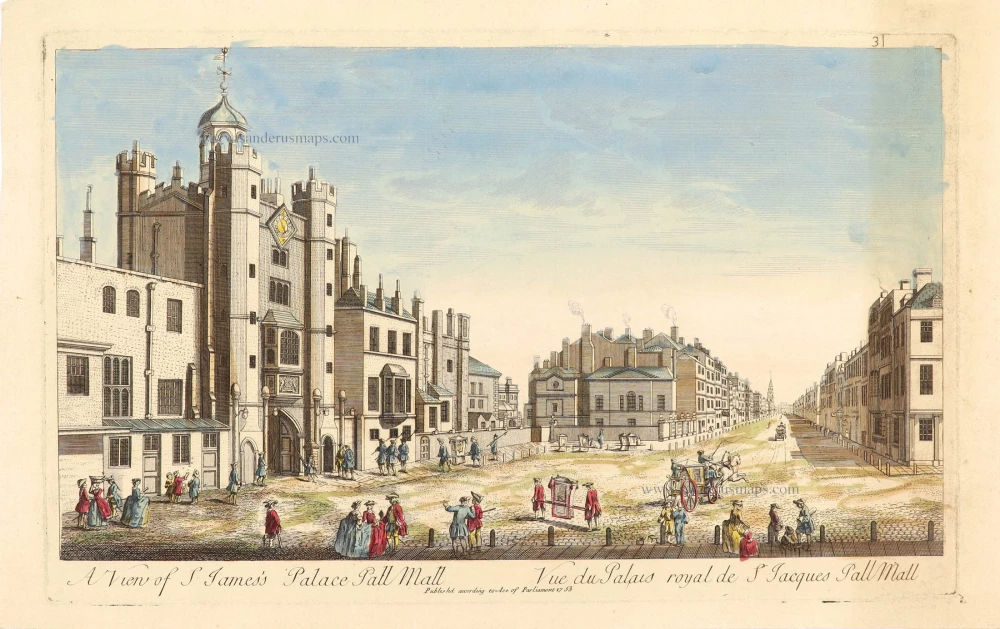
A View of S. James's Palace Pall Mall - Vue de Palais royal de S Jacques Pall Mall. 1753 or later
Anonymous view of S. James's Palace in London.
[Item number: 28986]
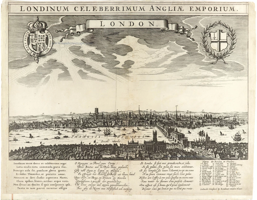
Extremely Rare panoramic view of London
Londinum Celeberrimum Angliae Emporium. - LONDON. c. 1638
Panoramic view of the City of London, by Rombout vanden Hoeye.
[Item number: 30543]